>

HIGHLIGHTS OF THIS INCREDIBLE EVENT THAT’S JUST HAPPENED!
-Epicenter was in Central Virginia (near DC). Felt in Washington, Baltimore, Philadelphia, New York City, Boston, Marthas Vineyard.
-Reports of Washington Memorial in DC TILTING.
-JFK Airport shut down
-Office through Manhattan, NYC evacuated.
-NYC Subway evacuated with fear of aftershocks
-The Pentagon was evacuated when the building began shaking.
-Twitter traffic suggests it’s been felt all over east coast
NEWS FROM THE NETWORKS
Magnitude 5.9 Earthquake Hits Virginia, Sends Shockwaves Throughout East Coast
D.C., N.Y. buildings evacuate as quake felt across East
NBC
Quake hits near Washington, D.C.
CNN
5.9 quake hits Va.; Felt along U.S. east coast
CBS NEWS
SPECIAL COVERAGE OF HURRICANE IRENE 2011
BEAUTIFUL BAHAMAS LOOKING DOWN BARREL OF A GUN WITH HURRICANE IRENE APPROACHING
While I shall be on the road by 10pm Eastern Time tonight (2.30am tomorrow GMT), I shall be updating the latest information via the blog Facebook page. Click LIKE and see my updates on Hurricane Irene
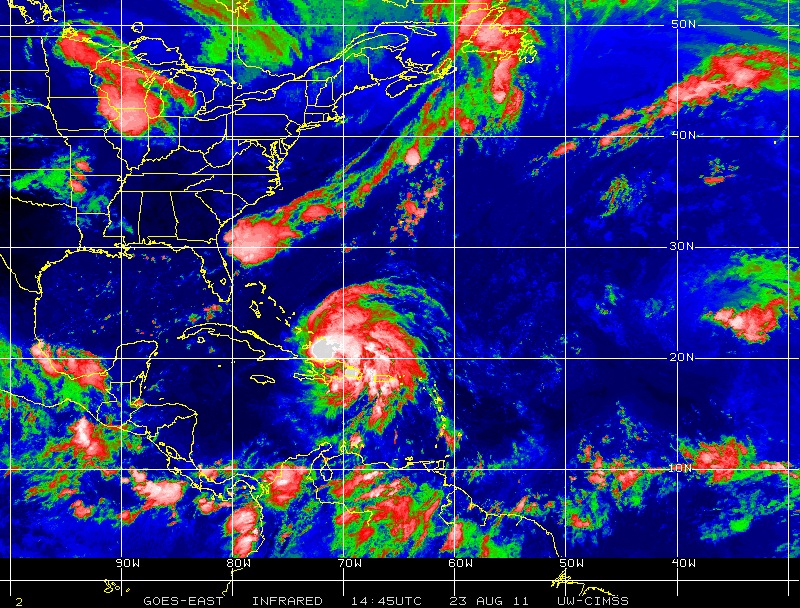
CURRENT STATUS AS OF 5AM ADVISORY
PRESSURE: 978 mb
MAX WINDS: 100 mph
MAX GUSTS: 120 mph
DIRECTION: WNW at 11 mph
Latest From the Networks
Irene intensifies over warm waters as it roars toward Carolinas
CNN
Hurricane Irene could hit U.S. as a monster
CBS NEWSHurricane Irene Marks First Big US Threat in Years
FOX NEWS
TURKS & CAICOS NEXT IN LINE

MY FEAR OF RAPID INTENSIFICATION OVER EXTREMELY WARM AND SHALLOW WATERS SURROUNDING THE BAHAMAS
The average water temperatures which Irene will cross in next few days is 84°, but within that uniform 84 degree waters lies pools or eddies of 91 waters.
The Bahamas are located at an expecially vunerable area of the Tropical Western Atlantic as the loop current becomes the Gulf Stream, here waters are warmest at greater depths and where the Bahamas lie, the sea floor is’nt as far down as surrounding areas and what that means is there is NO cool waters from deep below for the hurricane to churn to the surface and therefore limitation in intensification is less than in other areas which can often on the surface, appear as warm… That means, we may see stronger intensification than many believe and I am fearful that Irene may explode like we saw with Andrew in 1992, Wilma in 2005 and Charley in 2004 DIRECTLY over the Bahamas.
Historically, many storms which have crossed the shallow waters surrounding the Bahamas have exploded in intensity, that is my real concern and it is a year in which water temps are running 1-2 degrees above normal in the area Irene is spinning over and it’s a time where these waters are at their peak for heat content.
This graphic below from the CIMSS Tropical Site in Wisconsin shows the maximum heat content very well.
By Mark Vogan

In Other News
Largest Colorado quake since 1967 shakes homes
DENVER POST
Latest on Southern Plains Heatwave/Drought 2011
Altus has moved into a tie for second for triple-digit temperatures in a calendar year at 86 days.
OKLAHOMA NEWS
Heat watch: Torrid August continues as region’s reservoirs sink to record lows
HOUSTON CHRONICLE
THE EXTREMES OF THE DAY
TODAY’S EXTREMES HERE AT MY HOUSE
HIGH: 61
LOW: 45
Thanks for reading.
-Mark


")


Recent Comments