>Today’s Top Weather Stories
On Weather & Climate Through the Eyes of Mark Vogan
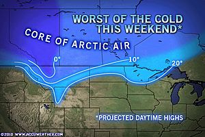
Bitter arctic air hurling into Montana and American West, but it’s going to get worse I’m affraid!
See Today’s Weather across America for details!
Quick-Hitting Snowstorm to Race Across Canada
AccuWeather News
Environment Secretary visits flood-hit Cornwall
BBC News
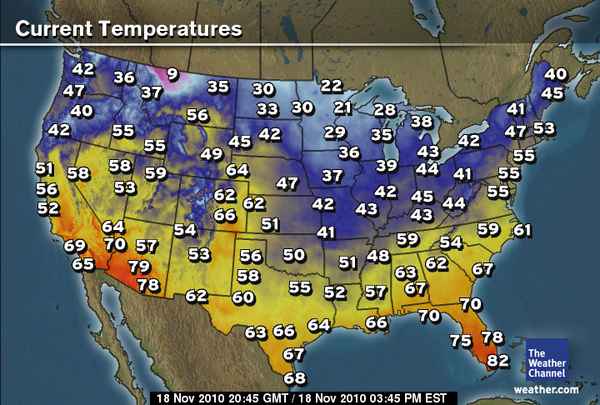
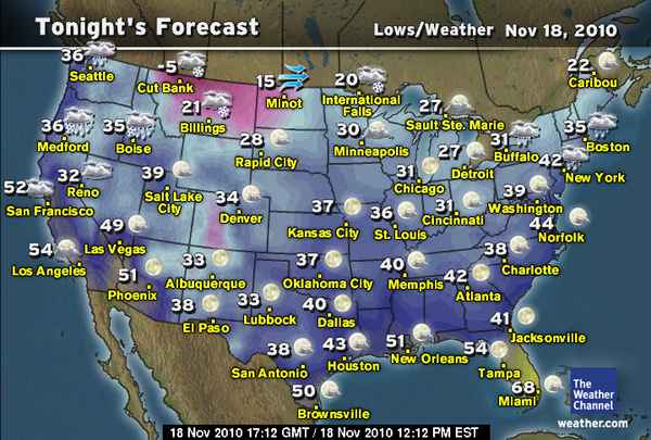
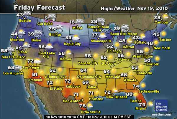
Today’s Weather across America
From AccuWeather
Harsh Weather this Weekend for Thanksgiving Travelers
By Heather Buchman, Meteorologist
Arctic Blast to Invade Northern Rockies this Weekend
By Brian Edwards, Meteorologist
Black Friday Shoppers Could Face Nasty Weather
By Heather Buchman, Meteorologist
Chance of Rain at Weekend NASCAR Races
By Gina Cherundolo, AccuWeather.com Staff Writer
Weather Talk
By Mark Vogan
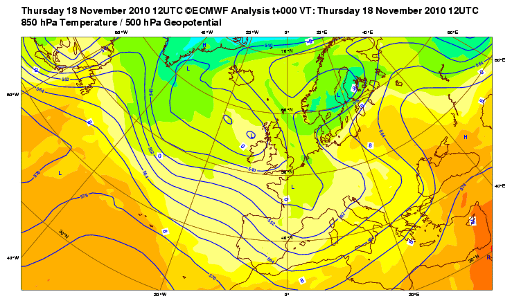
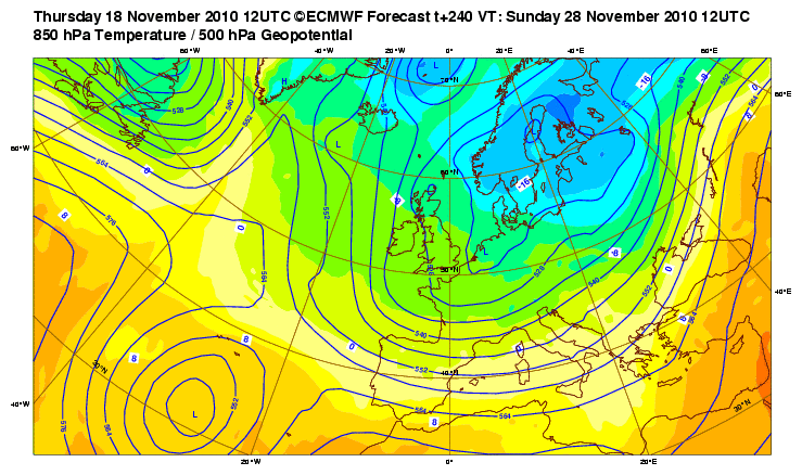
ECMWF paints a chilly picture for Great Britain the next 10-days, fits perfectly with my forecast!
Here is a look at the latest runs of the ECMWF with graphic 1 the current 850mb pattern, graphic 2 for this Sunday and graphic 3 for Sun the 28th. These three graphics illustrate well the downturn in temps over Britain and NW Europe between the period Nov 18-28. Note how Scandinavia fills up with Arctic air, also notice how the Greenland high progresses northwards and in response, the trough deepens as a stronger push of Arctic air drives southwest out of Norway, Sweden and Finland.

As to how much snow we’ll see across the UK, what cities and towns will see the white stuff and how cold temperatures will get, stay tuned as I shall be releashing a forecast for major UK towns and cities with where the snow will fall, how much I believe they’ll recieve and indeed just how cold are things likely to be.
The media, whether it be newspapers, STV, SKY or the BBC, there is more and more expectations building about snow and cold which should arrive next week. Remember, without sounding arrogant or big-headed, I DID FORECAST THE ARRIVAL OF MUCH COLDER AIR BY NOVEMBER 20TH onwards and indeed, at least up until now, models and the flip to a negative NAO/AO is proving me correct and a happy man. Of course it has to happen yet and signs are there as Scandinavia will begin filling up with blue over the next few days and then that blue will flood southwards towards us as NEXT WEEK progresses.. the arrival of snow perhaps as early as Sun or Mon should herald the beginning of a new pattern unfolding which should last through the following 2-3 week period which may turn out the worst of the entire winter for us here in NW Europe., please stay tuned for more on this!
What’s Reaching Today’s Blogs?
Thanksgiving Weather in the Icebox
Joe Lundburg, AccuWeather
Models Seem to Becoming into Agreement on the Storm Next Week
Henry Margusity, AccuWeather
My Own Missile Photos, More Contrail Fun
Jesse Ferrell, AccuWeather
The Extremes of the Day
Today’s US Extremes
Courtesy of AccuWeather
High: 85 degrees at Indio, CA
Low: 1 degree at Daniel, WY
Today’s UK Extremes
Courtesy of the Met Office
High: 55 degrees (12.9C) at Yeovilton (Somerset)
Cold High: 41 degrees (5.1C) at Carterhouse
Low: 36 degrees (2.1C) at Santon Downham (Suffolk)
Today’s Extremes here at my house
High: 44 degrees
Low: 42 degrees
Thanks for reading.
-Mark


")


Recent Comments