>Today’s Top Weather Stories
On Weather & Climate Through the Eyes of Mark Vogan
BREAKING NEWS
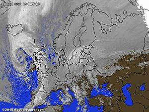
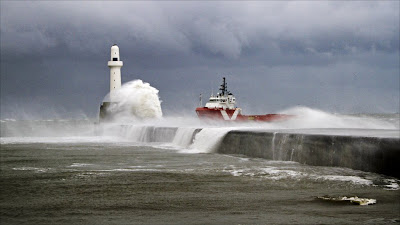
Severe Weather Strikes UK, Cornwall hardest hit
Cornwall floods force evacuation of more than 100 homes
BBC News
Weather warning for Scotland as forecasters predict sub-zero temperatures next week
Daily Record
IN OTHER NEWS
80 MPH Wind Gusts Damage Homes, Down Trees
WBALTV
Snowstorm blasts Montana, wreaks travel havoc
USA Today
Storms damage power lines, homes in Mid-Atlantic
USA Today
Snowstorm to Scoot across Southern Canada
AccuWeather News
Today’s Weather across America
From AccuWeather
Disruptive, High Winds Lashing the Northeast
By Meghan Evans, Meteorologist
Season’s First True Blast of Bitter Cold on the Way
By Heather Buchman, Meteorologist
Travel Center – Thanksgiving Travelers Face a Potential Travel Nightmare
By Henry Margusity, Expert Senior Meteorologist
Weather Talk
By Mark Vogan
THE COLD STAGE IS BEING SET AS -30s ARE SHOWING UP OVER NORTH AMERICA’S FAR NORTH!
Once temps were in the single figures F, now their in the -30s and falling, indicate’s the AO oscillation index is changing!
As the NAO (North Atlantic Oscillation) and AO (Arctic Oscillation) commences it’s shift to negative, forecasters on both sides of the North Atlantic are all now jumping onto the idea of their areas on both continents recieving a bitter Arctic blast next week.
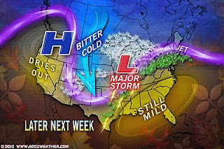
Yes, multiple US and Canada forecasters as well as Scotland’s STV Weather Weatherman Sean Batty has mentioned the colder air set to drop south across the country next week. Even in an article written in today’s edition of the Scottish Daily Record, it talk’s about colder weather hitting next week. This is all thanks to building pressure heights (High Pressure) now pushing northwards over Greenland and this in-turn will reajust the upper-atmosphere over the mid-latitudes. The jet becomes bunkled (meridional) and thus warm air pushes northwards and colder air shifts southwards. The position of this high means troughs set up either side and this of course buckles the jet stream. Because the high is positioned over Greenland and eastern North America and western Europe is situated either side, this means the troughs often (not always) but in this case will set up over both eastern and western sides of the two continents and thus cold, Arctic air will plummet into those twin troughs.
The AO is actually key in delivering the truely cold stuff down into the troughs that are set up via the transition to a negative NAO. Without the AO shifting negative, sometimes there’s no cold air to tap despite the bunckle of the jet over the N. Atlantic and drop south of the jet. The AO turning negative means, the oscillation releases the “bottled up” Arctic air that’s been brewing in the lack of sun, snowfield envirnoment over the Arctic circle to pole.
If you’ve been paying attention, Alaska and far north-central Canada haven’t been too terrible when it comes to cold temperatures. Perhaps in the -10 to -15F range. However the air has gotten decidedly colder over the past 26-48 hours and this is thanks to large-scale upper atmospheric changes and thus the Arctic air based directly over the pole and even over Siberia is now migrating southwards with the upper air flow. A cross polar flow is also hurling air from Siberia and enhancing the cold over North America’s upper reaches. With time, this air is going southwards and now we’re seeing Montana endure the first lobes of the sub-zero stuff.
As for here in the British Isles, we have seemingly been hit by one “deep Atlantic low” after the other, the question is, have these lows been deeper than normal? Perhaps, but remember, it’s November and lows do tend to deepen pretty good as they enter the northeast Atlantic on approach to Ireland. Every year we see gales and severe gales along the coast. I do speculate the theory that our lows of recent weeks have indeed been that bit lower than normal but I put this down to colder air not far to the north of Scotland and mild air hovering just off the south coast of England as well as warmer-than normal waters surrounding Britian as well as over the North Atlantic may be contributing to rapid deepning of Atlantic depressions on approach to the UK..
All the weather we’ve been enduring off the Atlantic will shift south and the Scandinavian ridge now in place up there should begin a journey southwestwards through the rest of this week and weekend and this will draw Arctic air southwards over Scotland and the rest of the UK next week.
Stay tuned for more on this ongoing weather story tomorrow and through the weekend!
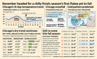
WGN-TV WEATHER CENTER’S GRAPHICAL LOOK AT THE NAO/AO TANKING
“Greenland Block” and the swing of key cold weather indexes to their negative phase all indicate a wintry chill for Thanksgiving week and beyond
By Tom Skilling
-Chief Meteorologist
WGN-TV Chicago
Chilly as this week’s Thursday/Friday temperatures are likely to be, two key cold weather indicies have turned decidedly negative in the next 2 weeks. Negative values off the Arctic Oscillation (AO) Index traditionally suggest a cold air build-up across Canada while a negative North Atlantic Oscillation Index (NAO) hints at ridging over Greenland and the North Atlantic—a set-up which encourages the development of a trough aloft over eastern North America. This appears to be a harbinger of cold weather as we head toward Thanksgiving next week.
What’s Reaching Today’s Blogs?
Heck of a Squall Line Last Night!
Jesse Ferrell, AccuWeather
Midweek Munchies and the Models Serving Them Up
Joe Lundburg, AccuWeather
A Series of Storms Will Bring Snow to the West and Plains. Next Week Colder and Snow in the East.
Henry Margusity, AccuWeather
The Extremes of the Day
Today’s US Extremes
Courtesy of AccuWeather
High: 89 degrees at Edinburg, TX
Low: -2 degrees at Pinedale, WY
Today’s UK Extremes
Courtesy of the Met Office
High: 55 degrees (13C) at Chivenor (Devon)
Cold High: 39 degrees (4C) at Bingley (West Yorkshire)
Low: 26 degrees (-3.2C) at Santon Downham (Suffolk)
Today’s Extremes here at my house
High: 43 degrees
Low: 39 degrees
Thanks for reading.
-Mark


Recent Comments