>Today’s Top Weather Stories
On Weather & Climate Through the Eyes of Mark Vogan
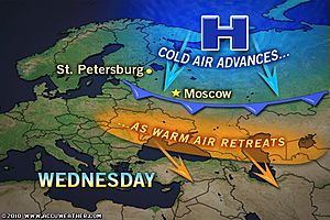
Record Russian Warmth Eases Wednesday
AccuWeather News
La Nina Floods Turn Deadly in Colombia
AccuWeather News
Today’s Weather across America
From AccuWeather
Wind-Whipped Snow Spreading from Montana to Nebraska
AccuWeather
Expansive Rainstorm Soaks the East
AccuWeather
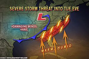
Damaging Thunderstorms Possible in the Southeast
AccuWeather
Thanksgiving Skiing Outlook for the West
AccuWeather
Weather Talk
By Mark Vogan
BOTH SIDES OF THE ATLANTIC EXPECTED TO GET COLD!
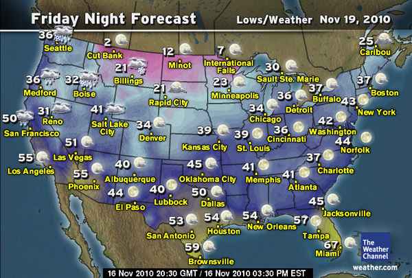
First Lobes of true Arctic air starting to dip southwards, Montana towns to have single digit highs, sub-zero lows by Friday-Saturday!
Up until now, the US and even here in the UK has had it fairly easy when it comes to winter so-far. Though I must admit, times have been chilly on this side of the pond with snow above roughly 1,000ft in the higher terrain of Scotland and England. As for the US, snow has been virtually non-existant, east of the Plains and temperatures have been well above normal.
This I’m affraid is all about to change. Blame the flip to a negative North Atlantic Oscillation and Arctic Oscillation. Both the US as well as here in the UK, we should be heading into a much colder pattern. Folks across side side, if you thought it’s been cold, well think again! By this time next week, it should be MUCH cooler and as November ends and December begins, we may be heading into a multiweek deep freeze which plummets temperatures and we see snow back in our cities and towns.

As you can see from The Weather Channel maps I’ve put up, note the highs dipping into the teens over Montana, the low single digits for lows…. With the flip from positive or neutral NAO and AO to negative, this builds a “blocking pattern” over the Northern Hemisphere and the high builds over Greenland. That high building northwards, up over Greenland allows Arctic air to head southwards and with the location of this high setting up sop over Greenland, this will send a trough down over both the USA and the UK as well as western Europe. An NAO flipping negative doesn’t always nessesarily mean true Arctic air will dive into the troughs the ridge up over Greenland creates, but a flip to negative in the AO (Arctic Oscillation) means that there’s a discharge in the arctic air out and away from the pole. Both a negative NAO and AO, often allows a colder pattern to evolve further south and into the temperature or mid-latitudes which make up the US and UK if that Greenland “block” is set up and aligned properly. This appears to be holding true so far and I do see the blast of cold coming which I have been expecting and did forecast.
For the USA, the Arctic air will drive south into the “West” and then push eastwards across the country and should be timed in such a way that much of the country from the Rockies to East Coast should have a darn cold Thanksgiving this year..
FRESH BATCH OF ATLANTIC WEATHER SWINGS INTO UK TONIGHT!
HIGHLIGHTS
*60-70 mph wind gusts expected along west coast!
*Tricky driving as heavy rains sweep up from the southwest but creep slowly across the country!
*Folks further east to see heavy rains later tomorrow and tomorrow night!
The current UK weather pattern is showing a return to stormy weather for the next 4-6 days with a brand new Atlantic storm system now knocking on the door. Expect gales, severe gales along the west coast and a band of heavy rain to move in tonight and through tomorrow. Milder air is also being transported in.
Vagaries of the Weather
India & Sub-Continental Asia Weather
By Rajesh Kapadia
IMD statement today: “Yesterday’s U/A Cycir over West M.P now lies over East Rajasthan and adj. areas and extends upto 0.9 Km. a.s.l”.
IMD confirms vagaries forecast !
Current System Update:
“System will cross as a depression, maximum it can cross as a DD”.That’s what vagaries had anticipated for the current low in the Bay.
Crossed T.N. coast today (16th. Nov) as a well marked low ! System was encountering resistance from shear winds since the last 2 days.And unfavourable developments were noticed since yesterday.
At this rate, will it survive its travel thru the peninsula land ? Can it emerge again in the Arabian Sea ?
Possibilities are 50-50. Since the movement is rapid, and comparitively fast, it may just survive a re-emerge.
On the happening of it appearing in the Arabian Sea, west coast is in for rain from Thursday.
Even otherwise, moisture spreading in the interiors can precipitate some rains in interior Karnataka and Mah.on Thursday/Friday.
I would maintain the Mumbai forecast as put up yesterday, Monday, 15th. November.
all views and forecast estimates as per the synoptic scene today.
I will be away camping in the Wildlife Sanctuary – Tambdi Surla & Mollem and Maina Lake, Goa, from Wednesday thru Monday. A breif update will be put up on Wednesday afternoon. Next full blog will be put up on Monday night.
See our partner’s blog HERE!
What’s Reaching Today’s Blogs?
A Rapid Change To Harsh Winter Conditions in 24 Hours
Ken Clark, Western Expert, AccuWeather
Two Big Storms, But Still Not a Lot of Snow. For Now
Joe Lundburg, AccuWeather
Can Hurricanes Collide?
Jesse Ferrell, AccuWeather
The Extremes of the Day
Today’s US Extremes
Courtesy of AccuWeather
High: 87 degrees at Vero Beach, FL
Low: 2 degrees at Alamosa, CO
Today’s UK Extremes
Courtesy of the Met Office
High: 55 degrees at St Catherines Point (Isle of Wight)
Cold High: 34 degrees at Strathallan (Perthshire)
Low: 19 degrees at Aboyne (Aberdeenshire)
Today’s Extremes here at the house
High: 42 degrees
Low: 26 degrees
TODAY’S COND
Another cold start though clouds rolled in midway through the night, slicing the cooling process and stopping temperatures from dropping as low as yesterday. A generally pleasant day with sunshine in between cloud.
Thanks for reading.
-Mark


")


>weather map for your blog,
http://www.theweatherland.com/
>Good work! Your post is an excellent example of why I keep comming back to read your excellent quality content that is forever updated.
Thank you!
replica dewitt watches