>See Weather & Climate Through the Eyes of Mark Vogan on Facebook and Twitter. What are you missing? Videos, Weather Info and promotional items which are NOT seen here on the blog! During your visit, click “like” and be a part of the blog.. thanks for reading and your support.
Haven’t seen my Winter Forecasts for the UK, Europe as well as US? CLICK HERE!
Today’s Top Weather Stories
On Weather & Climate Through the Eyes of Mark Vogan
BREAKING NEWS
Hurricane Tomas lashes already devastated Haiti
CNN
Hurricane Tomas Now Hitting Haiti with Flooding Rain
AccuWeather News
Strengthening Tropical Cyclone Taking Aim at India
AccuWeather News
Indonesian Volcano Unleashes Most Powerful Eruption
AccuWeather News
Thousands race to escape Indonesian volcano
CNN
Today’s Weather across America
From AccuWeather
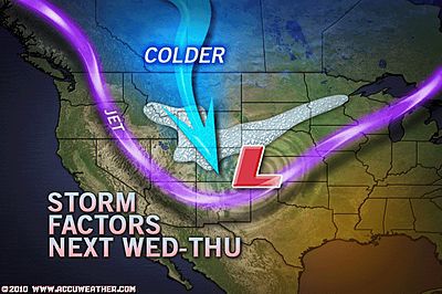
Snowstorm May Hit Large Part of West, Plains
AccuWeather
Snow for Great Lakes, Appalachians into Saturday
AccuWeather
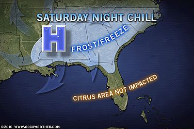
First Frost Coming to Florida
AccuWeather
Weather Talk
By Mark Vogan
North-south temperature divide across UK
66 degrees in London whilst only mid-40s over north-central Scotland
Milder, sub-tropical Atlantic air continues to finger it’s way through souther reaches of the UK and this is helped along by the Greater London heat-island as yesterday managed to warm to a very comfortable 66 degrees at St James Park in central London. I’m not sure what the actual low was but BBC forecasts were calling for lows around the London area to only fall to around 59 degrees. That is mild for early November but not really untypical when an Atlantic weather pattern is in conrtol and the air flow from the southwest draws warmer, maritime air into the south of England.
Yes, it’s cooler, much cooler over particularly northern Scotland, north of the southern boundary of the Highlands and the Highlands themselves are acting as a barrier between warmer Atlantic air which is covering even the Scottish central belt and much of Wales and England but modest Arctic air is trying to drop into the north of Britain with even snow being reported over Caithness and Sutherland.
Lows tonight will drop off as we now rest in between weather systems and thus we’ll see our temperatures drop into the 30s, even 20s in outlying rural areas. Some Highland glens may drop back to the mid or low 20s! Much of England will cool to near freezing in rural areaws which experience both clear skies and light winds. Whilst London will be cooler, mid to upper 40s should be their lowest, close to normal for this time of year.
Unfortunately the unsettled weather will no sooner dissappear before it returns. More wet and windy weather likely to resume in a day or so!
What’s Reaching Today’s Blogs?
The Land of Weather Extremes Continues
Joe Lundburg, AccuWeather
Snow Showers for the Northeast… Long Range Looks Interesting
Henry Margusity, AccuWeather
The Extremes of the Day
Today’s US Extremes
Courtesy of AccuWeather
High: 96 degrees at Santa Ana, CA
Low: 1 degree at Embarrass, MN
Today’s UK Extremes
Courtesy of the Met Office
High: 65 degrees at Yeovilton
Low High: 43 degrees at Aviemore (Highland)
Low: 29 degrees at Kinbrace
Today’s Extremes here at my house
High: 49 degrees
Low: 46 degrees
TODAY’S COND
Little in the way of temperature variation thanks to yet another long, heavy and persistent band of rain which continues to control our weather in much of central and particularly western areas of the country. Cooler air continues to lie up over the Highlands whilst slightly milder air (though staying cooler with all the wet, cloudy weather) remains over southern areas and bumped up against the southern Highlands. The mountains basically acting like a wall these days between cooler air and milder, Atlantic air.
Thanks for reading.
-Mark


")


Recent Comments