>See Weather & Climate Through the Eyes of Mark Vogan on Facebook and Twitter. What are you missing? Videos, Weather Info and promotional items which are NOT seen here on the blog! During your visit, click “like” and be a part of the blog.. thanks for reading and your support.
Haven’t seen my Winter Forecasts for the UK, Europe as well as US? CLICK HERE!
Today’s Top Weather Stories
On Weather & Climate Through the Eyes of Mark Vogan
Fatal floods as Hurricane Tomas sweeps over Haiti
BBC Weather
Tomas weakens to a tropical storm, passes over West Indies
CNN
Mount Merapi’s Worst Eruption in a Century Burns Houses and Trees
AccuWeather News
Today’s Weather across America
From AccuWeather
Northeast Warmup Spoiler
AccuWeather
Less Than Ideal Florida Vacation Weather for Sunday
AccuWeather
Stormy Weather Eying the West
AccuWeather
Temperatures Soar in the Nation’s Midsection
AccuWeather
Weather Talk
By Mark Vogan
UK Latest Weather
COLDER TONIGHT THAN LAST AFTER WHAT WAS THE COLDEST DAY HERE OF THE SEASON SO FAR!
If you folks across, particularly Scotland and perhaps the north of England though this morning was chilly, well tomorrow morning is likely to be colder. Despite a showery day and generally cloudy for many after that clear and frosty night temperatures certainly here at my home in Lennoxtown, East Dumbartonshire never warmed above 41 degrees, thus making this the coldest daytime maximum of the season so far.
We may see a -6 or even -7C tonight in the heart of the Highlands!
Tonight will likely not be the coldest of the season since we recieved a very cold low back at the close of October of 22 degrees (-5C), I don’t think it’ll drop to that level, however whilst I believe a 27 or 28 is more than likely here and a 28 in possible in both Glasgow and Edinburgh city centres and a 23 or 24 in rural central belt areas under those clear, calm and crisp skies, parts of sheltered valley locations over Stirlingshire, Perthshire, Argyll, Aberdeenshire and up through the central Highlands may see lows tonight will towards the coldest values witnessed so far, that of course is around 19-20 degrees or -6 to -7C.
Whilst we have some “cold days” over the next couple with Highland locales such as Braemar, Dalwhinnie and Aviemore all expected to stay between only 2 or 3C for HIGHS tomorrow and Monday, it’s going to be milder further south.
Tonight, there is a fairly solid band of rain covering portions of N. Ireland and much of the Irish Sea,. this band is being fed into Wales and will cross into the west Midlands through tonight. Cloudy skies covering much of England will hold temperatures in mainly the low to mid-40s (4 to 6C) whilst 45 to 48 is likely for London, much cooler than those past few nights where daytime highs were soaring into the mid-60s, glorious for the time of year!
Another area which is likely to see rain this evening will be much of the North Sea coast of England, anywhere from N. Yorkshire down to East Anglia should see showers being fed in from the sea.
NOTE: Incidently, Yeovilton was warmer yesterday with a 65-degree high than in many areas of the Florida panhandle and north where they only warmed into the low 60s!
After tonight and much of tomorrow, a fresh band of heavy Atlantic weather will roar in off the Atlantic bringing both heavy rain and wind, this batch of weather will spread west to east through Monday across much of the British Isles and this precipitation will fall as snow over the Scottish Highlands!
American West verses East: Stark Contrast in temperature!
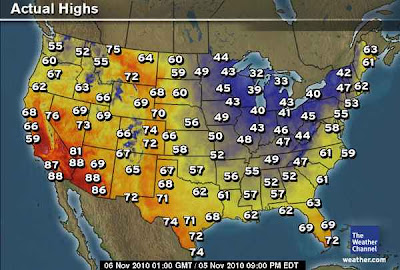
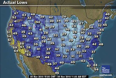
Mid-70s soar up through Montana, even Alberta and Saskatchewan, whilst 40s and low 50s are about as good as it got as far south as Atlanta yesterday, the low of 1-degree at Embarrass, Minnesota marks the second coldest national low so far!
Note the 75-degree high at Cut Bank, MT, at this point of year, it could more easily be in the 10s and 20s for HIGHS and lows below zero, but nope, that this November 5th…. As for the downside to this glorious pattern for folks in the Northern Rockies, those even in north Florida are paying for Montana’s joy as it only warmed to a dissapointing 62 degrees at Tallahassee and 63 at Jacksonville, Florida. That’s cooler than areas of London, England yesterday!
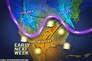
What’s even more interesting is the fact that, look at Maine, see those 60s whilst directly southwest in Vermont it’s only the low 40s. Note the 63 degree high at Caribou, anyother place that’s more likely to be below freezing rather than in the 60s. The 42 degree high at Burlington, Vermont is much more plausible. Indeed that is what happens when you got a highly amplified pattern in early November. Where’s there’s still warm to tap, it can go to strange places at a time of year when their meant to be colder, MUCH COLDER!
What’s Reaching Today’s Blogs?
Still Watching Tomas; A Few Quiet Days Ahead
Frank Strait, AccuWeather
The Extremes of the Day
Today’s US Extremes
Courtesy of AccuWeather
High: 88 degrees at Chandler, AZ
Low: 14 degrees at Tower, MN
Today’s UK Extremes
Courtesy of the Met Office
High: 57 degrees at Solent
Cold High: 38 degrees at Lerwick
Low: 24 degrees at Braemar
Today’s Extremes here at my house
High: 41 degrees
Low: 31 degrees
TODAY’S CONDITIONS
A chilly start as overnight rain-clouds dissipated and therefore allowed widespread cooling to occur over much of the country with a frost forming. With wet roads and rain drops on cars, this created a tougher morning of scraping, it’s always harder to scrape ice than frost!
Thanks for reading.
-Mark


Recent Comments