>See Weather & Climate Through the Eyes of Mark Vogan on Facebook and Twitter. What are you missing? Videos, Weather Info and promotional items which are NOT seen here on the blog! During your visit, click “like” and be a part of the blog.. thanks for reading and your support.
Haven’t seen my Winter Forecasts for the UK, Europe as well as US? CLICK HERE!
Today’s Top Weather Stories
On Weather & Climate Through the Eyes of Mark Vogan
latest news of tropical storm tomas
Tomas approaches Haiti; landfall expected in Cuba
CNN
Tomas Already Bringing Rain, Wind to Haiti
AccuWeather News
Tomas on Collision Course with Southern Bahamas
AccuWeather News
in other news
Tropical Cyclone Headed for India
AccuWeather News
Merapi Volcano Blasts Send Ash Clouds Sky High
AccuWeather News
Today’s Weather across America
From AccuWeather
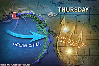
Colder Days Ahead for the Northwest
By Alex Sosnowski, Expert Senior Meteorologist
Drenching Storms Impacting Florida
AccuWeather
First Frost Coming to Florida
AccuWeather
Snow to Spread from Michigan to New York, North Carolina
By Heather Buchman, Meteorologist
Weather Talk
By Mark Vogan
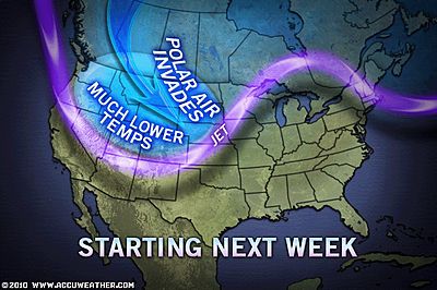
Coldest air of season set to blast into US East, but, remember, this is more of a shock because it’s been so warm!
Interestingly, AccuWeather pointed out in an article today that Gainsville on the Florida panhandle recieves it’s first freezing temperature on average on Nov 5th whilst New York City is not until the 14th, why do you ask?
Well remembering that when Arctic air sinks far enough south, there is literally nothing to block the Arctic air from dropping all the way down to Florida, and Florida’s north as well as the Panhandle is very open to surprisngly cold temperatures as well as wind chills.
New York, sits beside the warm Atlantic and also that harbor is always warm. Both the East and Hudson rivers also are warm at this early stage in the season… This coupled with the fact you’ve got such a strong urban-warmed environment, it’s no real surprise here that New York City averages late in the freeze… Even other major cities such as Chicago, even downtown Minneapolis will be perhaps as much as a few weeks LATER than a few miles outside those cities in recieving it’s first freeze…
As for the incoming chill, this is nothing particularly extreme or unusual, it may just feel worse simply because the nation as a whole has experienced such a warm October and summer overall.
UK Ready to feel the cooler weather, but Atlantic driven pattern looks to remain for another while
Despite a few colder nights returning by this weekend and likely we’ll see the coldest days of the new season where it may actually struggle to hit 40 degrees, even in the central belt whilst the Highlands may struggle to reach freezing in sheltered areas such as Dalwhinnie, though nights may rival those very cold levels of late October, I believe this is a mere relaxation period in between Atlantic weather systems and the storm train and milder weather will return before the on-set of real winter I expect to arrive, sometime between Nov 20 and Dec 1..
Stay tuned for more.
Vagaries of the Weather
India & Sub-Continental Asia Weather
By Rajesh Kapadia
Thursday, November 04, 2010
Depression still at the same strength as previous report.And the current progress is not encouraging.
Locationat 8.5N and 90E, remains at around the same 1200 kms ESE of chennai.
But, we had predicted a deepening today, but is at 1000 mb, and now expected to accelarate into a DD. I would wait to announce the cyclone formation as yet.
Crossing the coast would be on the T.N. coast. As a cyclone ??
Heavy rains could now commence along the T.N.coastfrom 6th,with increasing intensity by 6th, evening.
On the west coast, there the no chart available showing whether the vortex has crossed inland.But, looking at the satellite picture, I am of the opinion that it seems to have done so, what with the heavy thunder clouding in North Mah.
I am now, on the 4th, in Matheran, and this station has witnessed a violent thunderstorm from 6pm for 2 hrs.with heavy lightning and gusty winds, Matheran measured up 45 mms of rain in an hour.
Some of the thunder cells shifted towards north Mumbai region.
Check out our partner’s blog in-full HERE!
What’s Reaching Today’s Blogs?
Indian Cyclone Scenario Still Holds
Jim Andrews, International Expert, AccuWeather
Trying to Stave Off the Inevitable
Joe Lundburg, AccuWeather
Snow and Snow Showers Depending on Where You Live
Henry Margusity, AccuWeather
The Extremes of the Day
Today’s US Extremes
Courtesy of AccuWeather
High: 101 degrees at National City, CA
Low: 13 degrees at Shirley Basin, WY
Today’s UK Extremes
Courtesy of the Met Office
High: 66 degrees at St James Park (Central London)
Low: 31 degrees at Loch Glascarnoch
Today’s Extremes here at my house
High: 50 degrees
Low: 45 degrees
TODAY’S COND
A generally overcast and very wet day, the unsettled Atlantic weather regime continues.
Thanks for reading.
-Mark


")


Recent Comments