>See Weather & Climate Through the Eyes of Mark Vogan on Facebook and Twitter. What are you missing? Videos, Weather Info and promotional items which are NOT seen here on the blog! During your visit, click “like” and be a part of the blog.. thanks for reading and your support.
6 Days to Go!
COMING THIS HALLOWEEN ( SUNDAY, OCT 31st)
MARK VOGAN’S OFFICIAL 2010-2011 UNITED KINGDOM AND EUROPE WINTER FORECAST.. are you ready?
Today’s Top Weather Stories
On Weather & Climate Through the Eyes of Mark Vogan

BBC Scotland’s Gail McGrane on tonight’s Scottish Weather Forecast
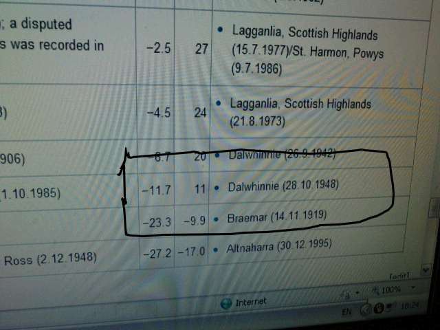
This morning’s 19-degree low (-7C) at Tyndrum, Stirlingshire may have tied for coldest low in UK for October in at least 10 years but nowhere near the the all-time record of 11 degrees (-11C)!
Last night really was a cold one and for me, may have been about as cold as I’ve experienced during the month of October. My official low this morning fell to -5.1C (22 degrees F), impressive on many levels. 1) Still early in the season, 2) Not located in an area that’s partcularly susceptible to cold air drainage or experiences much colder temperatures than it’s surroundings. This morning would have been cold for even a mid-winter morning and 3) There was no snow was on the ground to enhance the atmosphere’s ability in radiating heat back to space.

Images Courtesy of Wikipedia
Once hearing on the BBC Scottish Weather report this evening that the coldest temperature this morning was at one of the classic cold spot’s, Tyndrum, Stirlingshire (north of Crainlarich) which dropped to -7C this morning I believed this may have tied a national record for coldest in October. However by sifting through the internet, I managed to find some data provided by Wikipedia which states that the UK lowest for October is actually a much colder -11C which was apparently reached at Dalwhinnie in the Highlands back on 28th, October, 1948. The last time a morning low was this cold was another -7C (19 degrees) which was reached at Aboyne, Aberdeenshire in 2003. This reading was closely followed that same morning by a -6.9C (20 degrees) recorded at Shap, Cumbria and the last time we saw cold October nights was not so far away, back just two years ago when snow covered the streets of central London and dumped between 3-6 inches in outlying areas, as well as producing snow in many areas of the UK during the Arctic blast of October 2008, Topcliffe in North Yorkshire saw temperatures plummet to -6.6C, closely followed by the northern Highlands icebox of Altnaharra in Sutherland which hit -6.4C or 20 degrees F. Accross the North Channel and in southeast Northern Ireland’s icebox of Katesbridge, Co Down, they fell to -4.5C or 24 degrees F..
WORLD WEATHER TODAY
TOP STORIES FROM CNN:
Twister tears through northeast Texas, injures 4
7.5-magnitude quake strikes off Indonesian coast
also
Forecasters expect below-normal temperatures for UK
STV Weather
AccuWeather.com Canadian Winter Forecast for 2010-2011
AccuWeather News
Richard weakens after battering Belize
USA Today
Indonesia Volcano Unrest Raises Eruption Fears
AccuWeather News
Today’s Weather across America
From AccuWeather
Major Midwestern Cities at Risk for Severe Weather
By Heather Buchman, Meteorologist
High Winds, Power Outages Aim for Nearly a Dozen States
By Heather Buchman, Meteorologist
Big Mountain Snow, Blowing Snow in the Rockies
By Meghan Evans, Meteorologist
Weather Talk
By Mark Vogan
A VERY COLD MORNING GIVES WAY TO THE NEXT ATLANTIC WEATHER SYSTEM, SET TO BRING WIND AND RAIN AS WELL AS PROPEL HIGHS TO 60 DEGREES TOMORROW
The High Pressure cell which brought both sunny and cold weather over the weekend will give way to the next Atlantic low, presenting itself this evening as it’s leading cold front swings in off the Atlantic, effecting western areas of the UK mainland throughout tonight. It’s initial effects already impacting Northern Ireland and Ireland as well as the Western Isles of Scotland but as the late evening progresses into the early hours of Tuesday, southerly winds will pick up, clouds will increase and yes, it’s going to rain and in some areas rain heavy, particularly windward sides of hilly areas.
A heavy and persistent band of rain will progress eastwards across the UK throughout tomorrow, impacting eastern areas by later in the day tomorrow. The west will bare the brunt of windswept rain tomorrow but may actually brighten in the west tomorrow afternoon whilst the east gets the brunt of the nasty weather.
With the intruduction of milder air from the south as southerly winds blow, highs tomorrow may push 16C in many western (inland) as well as central areas by late afternoon as the band of rain pushes east and skies may clear in Northern Ireland, Ireland and western areas of the UK mainland. Ther BBC are forecasting Newry, Co Down to reach 17C tomorrow, 64 degrees F. Glasgow is expected to reach 15C with some areas of Ayrshire, Dumfries and Galloway and the Borders possibly reaching 16 or 17C, that’s if skies clear and sunshine is allowed to heat the ground along with south winds that are ushering in the milder sub-tropical Atlantic air.
Tonight, whilst many inland UK areas await the arrival of the cloud, wind and rain, the residual cold air remains, especially in areas which only warmed to between 6-8C today, including here at my house in Lennoxtown, East Dumbartonshire. With a period of clear skies and light winds, temperatures will be allowed to fall away, allowing frost to form and temps to dip to near freezing, even across the Central Belt and Southern Uplands of Scotland. Many central areas of England may get close to freezing and east and southeastern rural areas may see lows plummet into the cold -1 to -4C level, thanks to these areas seeing perhaps a full or near full night of light winds and clear, stary skies… I expect the coldest places tonight to be outside of Greater London where Oxford and Benson perhaps falling into negative territory but East Anglia may be the coldest spot in Britain this evening with perhaps a -4 or even -5C reading by dawn tomorrow.
Vagaries of the Weather
India & Sub-Continental Asia Weather
By Rajesh Kapadia
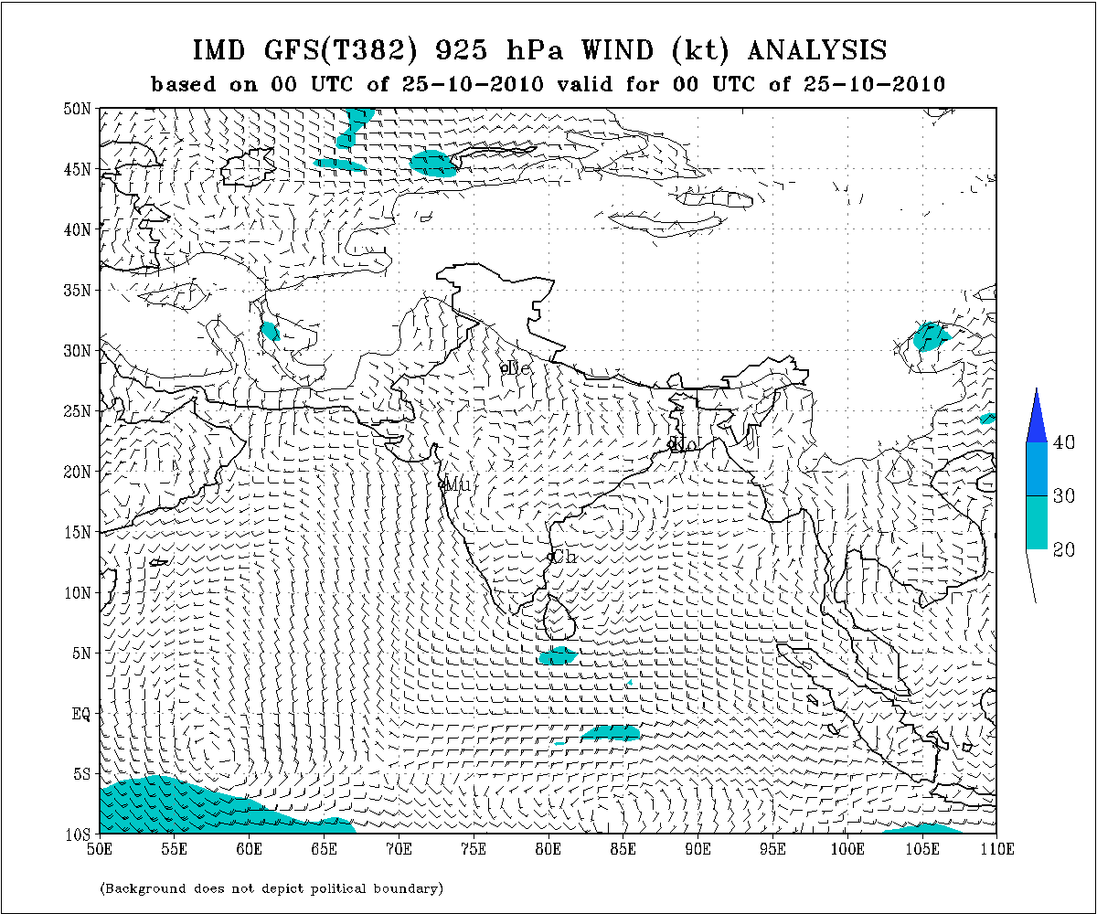
The wind pattern today indicates the monsoon having completed its tenure in Goa and regions around the 15N line.
Seeing the NE winds build up in the extreme south peninsula, I would transform the SWM to the NEM in a couple of days. The winds are indicative, but the strenght not very strong at the outset.
Mumbai page updated today for the unusual weather in the city.
See our Partner’s Blog In Full HERE!
What’s Reaching Today’s Blogs?
Tornadoes Sweep South, Including Mobile, AL
Jesse Ferrell, AccuWeather
A Wild Couple of Days with High Winds, Severe Weather and Snow
Henry Margusity, AccuWeather
The Extremes of the Day
Today’s US Extremes
Courtesy of AccuWeather
High: 99 degrees at Del Rio, TX
Low: 18 degrees at Leadville, CO
Today’s Extremes here at my house
High: 45 degrees
Low: 22 degrees
TODAY’S COND
After one of the coldest starts possible for an October morning with a low which easily bypasses the “average low” for the coldest time of year, never mind October and after a slow recovery as temperatures remained in the 20s until 9.50am and didn’t get above 30 degrees until as late as 10.30am. The day remained mostly bright and sunny but as the day wore on, skies began clouding over from the west, it remained a chilly autumnal day with a slight breeze which may it feel cooler, by late evening rain entered the area ahead of a new Atlantic weather system.
Thanks for reading.
-Mark


>weather forecast from GFS,
http://www.theweatherland.com/