>See Weather & Climate Through the Eyes of Mark Vogan on Facebook and Twitter. What are you missing? Videos, Weather Info and promotional items which are NOT seen here on the blog! During your visit, click “like” and be a part of the blog.. thanks for reading and your support.
5 Days to Go!
COMING THIS HALLOWEEN ( SUNDAY, OCT 31st)
MARK VOGAN’S OFFICIAL 2010-2011 UNITED KINGDOM AND EUROPE WINTER FORECAST.. are you ready?
Today’s Top Weather Stories
On Weather & Climate Through the Eyes of Mark Vogan
HISTORIC MIDWEST STORM ONE OF STRONGEST ON RECORD, BREAKS LOW PRESSURE RECORDS AND CREATES HAVOC TO TRAVEL ON LAND AND BY AIR AND LIKELY ON THE GREAT LAKES AS 27-FOOT WAVES ARE EXPECTED
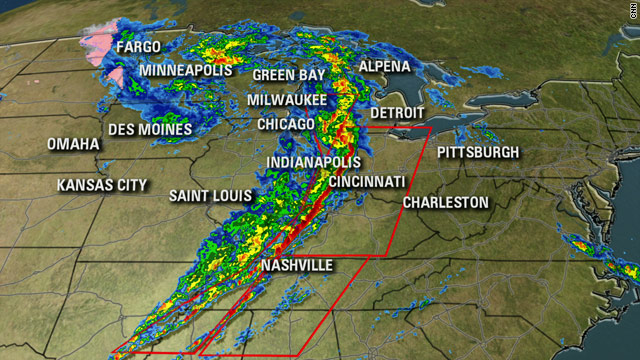
Courtesy of CNN
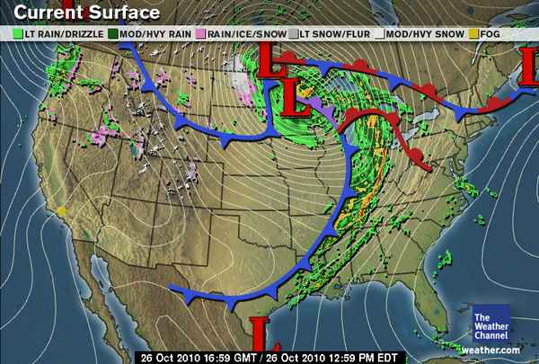
Courtesy of The Weather Channel
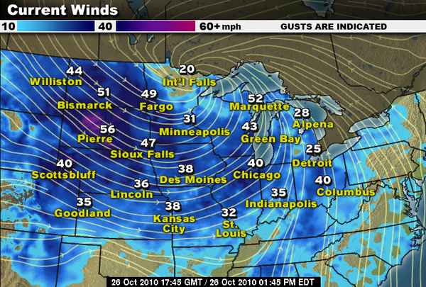
NEW: Severe storms, near-hurricane-force winds blow through Midwest
CNN
STORY HIGHLIGHTS
NEW: Illinois youth describes “explosion of glass” during apparent tornado
NEW: Indianapolis skyscraper is briefly evacuated
Tens of thousands are without power
Wind gusts exceed 70 mph in places; storm isn’t weakening as it speeds eastward
Hurricanelike Winds Hammer the Heartland
AccuWeather News
Blizzard, Cold Plunge into Northern Plains
AccuWeather News
IN OTHER NEWS TODAY

Image Courtesy of CNN
BREAKING NEWS: Volcano erupts in Indonesia, forcing thousands to flee
CNN
At least 112 dead, more than 500 missing after Indonesia quake
CNN
COLDEST NIGHT IN 17 YEARS FOR AREAS OF BRITAIN
Britain freezes on the coldest October night for 17 years as mercury plummets to -6C
The Daily Mail
Frozen Britain braves coldest October night for 17 years
The Daily Telegraph
Today’s Weather across America
From AccuWeather

VIDEO: Historic Storm Continues to Produce Tornadoes/High Winds
By Henry Margusity, Severe Weather Expert, AccuWeather
Millions Could be Without Power in Midwest Next Few Days
By Heather Buchman, Meteorologist
Tornadoes Sprawling from Michigan to Tennessee
By Heather Buchman, Meteorologist
Weather Talk
By Mark Vogan
UK WEATHER
AFTER SEVERAL PLACES RECIEVED THEIR COLDEST OCTOBER LOWS ON RECORD YESTERDAY AND A DAY OF MILDER AIR ACCOMPANIED BY WIND AND RAIN, A SECONDARY WAVE OF RAIN AND STRONGER WINDS ARE SET TO STRIKE TONIGHT
As winds rise across the Central Belt this evening from a southerly or southwesterly direction after a wet but generally calm and extremely dull day, keeping street lights on all day long, temperatures are continue to climb through this evening as a secondary frontal system pushes in off the Atlantic.
This morning and throughout this afternoon my temperature here in Lennoxtown has been generally in the low 50s, though a good deal milder than yesterday where the high only reached 45 degrees and having started off with a very cold 22 degrees, as of this writing (7.40pm) my reading is now at 56 degrees and continues to rise, this value is actually the mildest since a 56-degree high back on Tuesday 14th and today marks the first day with a temperature which has topped 50 degrees since Sunday 17th, yes it has been fairly cool of late.
The rise in temperature through tonight and a likely low by morning which may only get to perhaps 54 or 55 degrees is thanks to an Atlantic low which will progress east over far northern Britain, this not only wind send impulses of rain through the region tonight but winds are likely to pick up and with the push of southerly winds, temperatures may reach 60 degrees through the overnight before dropping off slowely tomorrow as this next batch of weather moves through.
The Central Belt will see winds blow 15 to 25 mph tonight and bands of hefty rain showers are likely but the worst of the weather as we saw through last night and today will be confined to the west of Glasgow and up towards Fort William and Cape Wrath, immediate coastal areas and the western and northwest Highlands will be in for yet more wild weather with gales and in spots, severe gales that will send wind speeds to 70 mph or higher as well as intense impulses of blinding rain, temperatures will remain mild with overnight readings across much of the country and particularly to the west remaining above 50 degrees (10C).
Further south, areas of Southern Scotland will remain mild also with blustery winds out of the south and southwest with on and off showers.
Down through Cumbria and the rest of the north of England, will also see breezy conditions with showers, lows remaining mild also. As for the rest of the country, it will remain mild, with some clear skies and on and off showers. The mildest air is likely to be found around the south and southeast of England where London may remain in the upper 50s to even near 60 degrees overnight.
What’s Reaching Today’s Blogs?
Stats On Powerhouse Midwest Storm
Jesse Ferrell, AccuWeather
A Very Bad Day for Many People. Wind Damage, Tornadoes Today
Henry Margusity, AccuWeather
Weather Opposites
Joe Lundburg, AccuWeather
The Extremes of the Day
Today’s US Extremes
Courtesy of AccuWeather
High: 96 degrees at Laredo, TX
Low: 12 degrees at Chama, NM
Today’s UK Extremes
Courtesy of the Met Office
High: 65 degrees at Murlough
Low: 27 degrees at Santon Downham
Today’s Extremes here at my house
High: 56 degrees
Low: 39 degrees
Thanks for reading.


Recent Comments