>Today’s Top Weather Stories
On Weather & Climate Through the Eyes of Mark Vogan
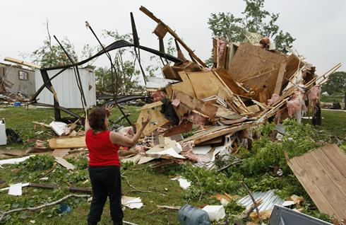
Photo courtesy of the USA Today
Vicious Tornadoes kill at least 5 on the Plains yesterday, more deaths likely in days to come with the type of pattern in place
-Mark Vogan-
oklahoma, u.s.a
Recap of Monday’s deadly tornadoes
AccuWeather.com
iceland, europe
Ash fears close Spanish and Moroccan airports
BBC Weather
america
2010 Atlantic hurricane season could rank in the top ten
AccuWeather.com
china, asia
Early, deadly start to southern China rainy season
AccuWeather.com

Check
out
the
Latest
from
the
field!
By Tom Skillingon May 11, 2010 1:48 PM
What change from Monday! The sun’s out brightly Tuesday and warming is underway. It’s a stunning turnaround from Monday when southeast howled, skies were shrouded in clouds, there was drizzle and temperatures languished in the 60s. Monday was one of those days which made a good thick jacket feel awfully good!
We’re southbound in Oklahoma heading into a humid, energetic air mass advertised by the latest RUC model as likely to possess off -the- scale CAPE (atmospheric energy) values over 5,500 j/kg by later this afternoon! That’s an air mass even more energetic than yesterday’s–when the atmosphere managed a cluster of supercells which spawned the multiple vortex twister we encountered. Among the other big atmospheric changes we’re noting Tuesday is the presence of a “cap”–a rain-inhibiting warm layer aloft which thwarts the ascension of air needed for cloud and storm formation and the fact the “dry-line”, along which thunderstorms flared fairly early Tuesday afternoon has retrograded (slipped westward) into western Oklahoma and the Texas Panhandle. Still, the RUC model suggests the cap is likely to break later this afternoon—a notion supported by our high-resolution RPM model, though RPM shows the cap breaking later–more toward 6 or 7 pm.
A dormant warm front divides powerful southerly winds, blowing at up to 40 mph, and ligher southeast winds. There’s split in the jet stream over Oklahoma, a proxy for regions in the atmosphere where air is rising.
Here’s what all of this seems to suggest—and what we’ll be monitoring as we continue heading south in Oklahoma. It is the consensus view herer that the current rain-inhibiting cap is likely be breached late this afternoon or evening–a development which should allow towering, lightning-generating cumulonimbus clouds which, more than yesterday when they were shrouded in stratus, to appear dramatically on the horizon.
Severe weather can’t be ruled out, including twisters. We’ll keep you posted.
We plan on our 5pm WGN News program to give you a look at our chase vehicles and the satellite truck from which we are uplinking our reports back to WGN. And tonight at 9PM, our series on the revolution in meteorology continues. We look at supercomputer modeling of the atmosphere and take you inside the National Weather Service’s supercomputing facility outside Washington, D.C.
Today’s Weather across America
From AccuWeather
Photo/Image courtesy of Jesse Ferrell’s blog
Second round of severe thunderstorms, tornadoes tonight, Wednesday
AccuWeather
Why suddenly so many tornadoes?
AccuWeather
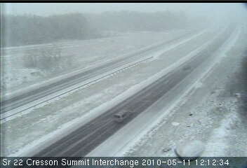
More snow for the West
AccuWeather
Weather Talk
By Mark Vogan
THIS IS THE EXACT SAME AIR MASS THAT’S CURRENTLY NOW HOLDING A FIRM HAND ON US BRITS, THAT BROUGHT US ONE OF THE WORST WINTERS IN HISTORY
Just so as you are aware as many of us have seen snow flakes or sleet fly through the air BELOW 1,000ft in central Scotland and even accummulating, heavy snowfall over the central and northern Highlands of Scotland today, this is the same air mass and same upper-level pattern that controlled our atmosphere over the past winter.
This air, is simply a May-version of the exact same air we endured in late December through March. Added daylight and a much stronger sun has meant this air mass comes in “weaker” which would be obvious, given the time of year and it also filters in more from above “aloft”, the cold air is really more above our heads and has a tough time getting down to the surface due to other factors at work during late spring, a major one being strong solar rays reaching the surface which heats the lower atmosphere much more efficiently, therefore making it tough to bring “cold” air to the surface and keeping it there.
We likely have frigid air about 10,000ft above our heads (-15 to -20C) which is racing powerfully south towards Spain from the Arctic. With a stronger, more powerful trough, we have a colder than normal spring trough which is allowing below-freezing air (day & night) down to perhaps 5,000ft above our heads and with the correct dyanmics of jet stream alignment, wind mixing etc, we are able to force little pockets or envelops of this air down below 2,500ft. Currently we have a strong north flow which is racing at around the 850mb height (or 5,000ft level) and such a strong wind and it’s embedded precipitation bands pushing with it across Scotland, is forcing snow, not rain to fall to the ground over many Munro hills and where there are sheltered glens below munro level, their seeing snowfall, in some areas accummulating on grassy surfaces.
Some of these waves or isolated “pockets” of showers today around Ayrshire and the higher ground of south and southwest Glasgow have witnessed sleet showers. I happened to be at Mill’s Dairy which is at an elevation of approx 750ft and a mere 4 miles from the coast and I saw snow flakes flying!
The shear strength of this trough (it’s depth) represented by it’s “low thickness values or “low heights” known in meteorology is a measure of how cold the air is aloft and it’s very strong north wind, the ultimate transporter, delivering the air from it’s point of origin or source region to whereever the wind blows it to, the strength of the flow means how fast it can get from one place to the next. A stronger flow blowing straight from the Arctic to Scotland means this air has less time to modify and heat up, therefore we are seeing cold surface temps and the snow and sleet showers. This trough and the northerly flow is so cold that it’s illustrated well by managing to beat the confliction of a late spring, early summer surface environment or lower atmosphere and has managed to surpress temperatures to only 5-8C in the heart of the day and harness snow/sleet showers all the way down to elevations under 1,000ft, near to the coast of central Scotland in mid-May. I could appreciate this to be less extreme at elevations above 3,000ft or even 2,500ft but in order to reach May 11 and see snow falling below 1,000ft and sleet below 500ft is very impressive indeed and something I’ve never seen this late in my lifetime. In fact I don’t ever recall an accurance of snow in May at low levels.
A few of you have now asked, are we still on par for a good summer, like I’ve been predicting… The answer is YES, this pattern we are in just now won’t last, it simply can’t and I do think that last summer “early tease” with plenty of sun and heat, it may have hit too early and simply burnt itself out before it could even start…. This year, we haven’t seen summer yet… Scotland hasn’t even recorded a 22C reading yet, but it’s still early and because we had such a powerfully cold winter, the atmosphere may have a longer, tougher time to reajust. This could be a hangover to what was one of the worst winter’s in our history.
Here are some reports I heard and comments I recieved today from other areas…
Newcastle on the North Sea coast recieved snow today – BBC Weather –
“Caithness, near dunnet head – snow showers yesterday, & heavy snow shower 7.15am this morning. All the fields went white! Snowed again 1pm” – From a reader near Dunnet Head, Caithness
Thoughts roaming my head….
1) Could a cold Spring/May signal a warm/hot summer?
2) Does an early spell of summer warmth and dry weather portray damper, cooler times in the heart of summer like last year?
These questions do have no backing but are simply thoughts that I thought I would share with you my loyal reader.
It’s also wintry across areas of the interior Northeast US… I urge you to read Jesse Ferrell’s blog post from today!
What’s Reaching Today’s Blogs?
May Cold and Snow From West to East
Jesse Ferrell, AccuWeather
Nashville’s Katrina” (and a cold, soaking rain here at home)
Paul Douglas’ Weather Column
** Check out Conservation Minnesota for more GREAT weather and see what Paul has created!
VAGARIES OF THE WEATHER
By Rajesh Kapadia of Mumbai, India
**Keep checking back to Rajesh’s blog as he delivers superb info and insight on weather patterns across India and the sub-continent of Asia!
Readings as on 11th. May
Hottest in Asia: Chandrapur( Maharashtra, India): 46.6c
Minimum Temperatures over 30c in the Indian Sub-Continent:
Kurnool: 31.7c, Amraoti 30.8c, Kota 30.7c, Hyderabad 30.0c
Today’s US Extremes
Courtesy of AccuWeather
High: 99 degrees at Pecos, TX
Low: 12 degrees at Bridgeport, CA
Today’s Extremes here at my house
High: 60 degrees
Low: 31 degrees (Frost)
Thanks for reading.
-Mark


")


Recent Comments