>

Today’s Top Weather Stories
On Weather & Climate Through the Eyes of Mark Vogan
MARK VOGAN PRESENTS TO YOU SPECIAL COVERAGE OF TOM SKILLING’S WEEKLONG STORM CHASE
NEW: Skilling Storm Chase Team following a tornadic supercell in Northern Oklahoma
By Mike Hamernikon May 10, 2010 4:24 PM
Tom Skilling and the WGN Storm Chase Team have been following a tornadic supercell that has been raking across far northern Oklahoma since 3:45PM. This tornado will be moving into southern Kansas shortly with the WGN crew in hot pursuit.
Here is a list of some of the damage this storm and its associated tornado have been responsible for:
4:36PM: Spotters report a tornado on the ground in 8 miles NE of Braman, OK
4:28PM: Law enforcement reports two tornados on the ground 2 miles south of Hunneywell, KS
4:08PM: Large tornado on the ground 6 miles east of Renfrow, OK
3:58PM: Houses with damage from a tornado in Clyde, OK
3:58PM: Chaser vehicle (hopefully not Tom’s) with all of its windows blown out from baseball sized hail
3:43PM: Significant damage in Medford, OK from a tornado.
CHECK OUT THE WGN WEATHER BLOG NOW FOR MORE AND ALL THE VERY LATEST FROM THE FIELD.. ALSO MAKE SURE AND WATCH WGN-TV TONIGHT AT 9PM CENTRAL FOR LIVE COVERAGE FROM TOM, JIM AND THE TEAM… (By MV)
Storm Chase Eve
By Tom Skilling on May 9, 2010 9:45 PM
Potentially historic tornado producing storms are bearing down on Kansas in the next 24 hours.
We’re still checking the latest weather data to decide how to best position ourselves to bring you coverage without getting ourselves killed. We hope to blog frequently on Monday-should be plenty to share. After 42 years of covering tornadoes from a windowless weather office, Chief Meteorologist Tom Skilling may actually get to see one!
WGN Storm Chase coverage starts tonight at 9PM!
We’re just hours away now from our first report in what promises to be a week of very interesting and yes frightening weather moving our way in Wichita, Kansas. Our satellite truck crew just arrived, and we’re waiting for the WQAD team to roll in.
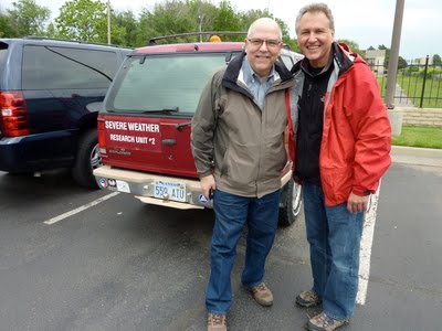
We’ll get our safety briefing tonight from Extreme Weather Expert Jim Reed… (above)… can’t wait for you to meet him tonight at 9. Has HE got some weather stories to tell as you’ll see tonight!
Also in our story…surprises for two science teachers in Springfield, Illinois who hadn’t seen Jim in over 30 years!
Below is the ever generous Tom Skilling treating us to breakfast in Old Town Wichita. It was a packed house on this Mother’s Day.
I (Pam Grimes-Producer) took the above picture in the parking lot of the Hampton Inn in Wichita. That’s Jim’s trusty chase vehicle that’s been with him some 320,000 miles! But “she” doesn’t have a name. Anyone? Anyone?

This information and photos are courtesy of WGN-TV.com
Follow thier progress minute by minute here on the CHICAGO WEATHER CENTER link and WGN-TV WEATHER BLOG where there’s great photos and video…
other global weather news
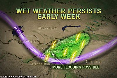
tajikistan, asia
Rain to continue after deadly Tajikistan flooding
AccuWeather News
Snowstorm to blanket part of Colorado, Wyoming
AccuWeather News

Today’s Weather across America
From AccuWeather
BREAKING NEWS:
*Dangerous tornado outbreak in Kansas and Oklahoma
*PORTIONS OF NORTHERN PA FALLS TO 22 DEGREES THIS MORNING!
Why so darn cold?
AccuWeather
Killing frost in the Northeast tonight
AccuWeather
Oil slick to reach more of Louisiana coast this week
AccuWeather
Weather Talk
By Mark Vogan
Britain in a winter air mass
The air currently in place over all of British airspace is that of an Arctic origin. A strong upper air flow is blowing straight from the Arctic and thus we feel nothing like we should for May 10th. I recieved an email from a gentlemen today which stated:
“snowing as I type light showers nothing lying plus 2.4c this morning, snow looks to be staying on the ground at about 700mts. Still tons and tons of snow on hills”
A few centimeters is expected tonight over areas of Scotland above a few hundred metres, so this shows you just how cold this air is and where it’s coming from… We could incidently be enjoyed highs in the low 20s at this point in the year, sure we’re enjoying decent spells of sunshine indeed but we do have a very, very different air mass over us, rather than the subtropical air mass which would typically be driven aboard southwest winds up from the Azores, we have winds funnelling all the way down from northern Scandinavia and this is is forcing highs of only 7-10C (45-50F) and winds that make it feel even colder as they blow fresh from the north and northeast. This chilly air is forcing snows to break out and even supports sleet down to near sea-level in exposed eastern areas where the wind is raw and un-warmed directly off the North Sea.
Frost for much of inland Scotland/north England tonight?
Well, as of this moment, light showers are being driven in on a chilly wind with a current reading here of 43 degrees, skies have broken, patchy cloud and despite that wind mixing the air and even the patchy cloud, we are still falling slowly, which is shear testament to just how cold this air is for May… Remarkable.
If skies can clear out and winds lighten, I expect a low here of betwen 0 to -2C tonight (32-28F) and skies are expected to clear out completely overnight, so with the evidence of very cold, Arctic air in place and a clearing of skies, any daytime heat will be forced back to space and therefore we should take a run at these very low readings which may dawn May 11. Stay tuned.
What’s Reaching Today’s Blogs?
Seiche, Snow, High Winds Down Trees in Northeast
Jesse Ferrell, AccuWeather
Cold Storm Brings More May Snow
Ken Clark, Western US Expert, AccuWeather
India and Asian Sub-Continent Weather
Readings of 10th. May & Monsoon Watch – 6
Rajesh Kapadia, Vagaries of the Weather
Major outbreak of severe storms including wedge tornadoes
Henry Margusity, AccuWeather
NEW VIDEO BLOG NOW AVAILABLE ON Facebook!
Today’s US Extremes
Courtesy of USA Today
High: 103 degrees at Fort Stockton, TX
Low: 15 degrees at Doe Lake, MI
Today’s UK Extremes
Courtesy of the Met Office
Warmest High: 61 degrees at Solent (Hampshire)
Coolest High: 43 degrees at Lerwick (Shetland)
Coolest Low: 29 degrees at Benson (Oxfordshire)
Today’s Extremes at my house
High: 52 degrees
Low: 41 degrees
Thanks for reading.
-Mark


")


Recent Comments