>Today’s Top Weather Stories
On Weather & Climate Through the Eyes of Mark Vogan
Another Day of Severe Weather expected for a region stretching from Oklahoma to Missouri, Heavy Snow for Denver and a 30 below normal high could be seen for Rapid City today
great britain, europe
Weather forecasters record coldest May night since 1996
BBC Weather
libya, africa
Plane crashes in Libya; Moroccan airports closed due to ash Tuesday
AccuWeather.com
Follow the latest on Tom Skilling’s Storm Chase at Chicago Weather Center and make sure and watch WGN-TV at 9 CT tonight for live coverage!
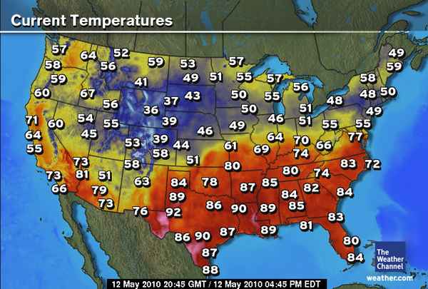
Today’s Weather across America
From AccuWeather
More tornadoes threaten Oklahoma, Kansas, Missouri
AccuWeather
Snowstorm departing Colorado, Wyoming
AccuWeather
Weather Talk
By Mark Vogan
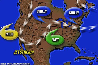
TWIN TROUGHS AS NEGATIVE NORTH ATLANTIC OSCILLATION CONTINUES
We have continued “blocking” over the hemisphere which is responsible for such cold here in Britain as well as the Eastern US where snow was falling enough to lay down a 2-3″ blanket over the higher ridges of central Pennsylvania and also snowfalls on and off across New England in previous days also. Yesterday, whilst it snowed in one unusual place for May, the same could be said for here in the UK. Though we are much farther north than PA’s latitude, our latitude being in line with Hudson Bay, Canada and New York/PA being as far south as North Africa and the Mediterannean Sea, these TWIN TROUGHS are associated with a strong blocking ridge of high pressure over the North Atlantic ( the result of a negative North Atlantic Oscillation) which played a major role in our past winter, but it certainly hasn’t shifted and allowed nice warm sub-tropica high’s to progress into our area of the world just yet, in fact those places in southwest Europe are not much warmer than we are because the trough has dropped so deeply of late, forcing enough chill, far enough south which has produced unprecidented snows in the south of France and even Spain.
There are multiple cold pools over the northern hemisphere, one over the Western US, Northeast/Eastern US and the UK, the building sub-tropical ridge which is progressing northward day by day is being supressed in areas and forced to punch through weak areas of troughiness (eastern Europe). Central & Eastern Europe as well as the Sunbelt of the US South is warming nicely but troughs are winning out, but for how long…
When they eventually weaken enough, have we heat waves looming in those same places suffering unusual cold and late snows?
Is this stubborn North Atlantic “blocking high” associated or caused by volcanic activity? Perhaps the intensity and persistency of the trough and Arctic air ruling over the winter has lead to complications in allowing summer heat up to Britain?
We had snow as far south as Sunderland yesterday, as low in elevation and as close to modifying influences of sea air as the northeast Engligh city of Newcastle! Here, my local hill tops showed a dusting of snow after overnight rains down here, only 10 minutes from my house and an elevation difference of only “hundreds of feet” and rains turned to snow. Snow and sleet showers have been reported all over central Scotland, as far south as Dumfries and Galloway and as far north as Caithness… This is an air mass that would do March proud! So is this cold in Mid-May, the “ghost of winter past” and the atmosphere has been scarred, leaving a longer “transitional lag” than normal? or is this something much greater and worrying for later down the road? Has the Icelandic volcano release of ash played a part? In the near term, no I don’t think so, but who knows for sure the hows and whys?
Is it possible to see yet another sub-zero low this month over the American West?
When you see just how cold the air mass is behind the Pacific storm center which is over the central Rockies I wonder is it entirely possible that in between snow showers, we see enough clearing and enough downward sinking of frigid mid to upper level air to the surface in one of those cold hollows of the Western basins and valleys that yet another low sinks below zero…?
What’s Reaching Today’s Blogs?
Vagaries of the Weather
By Rajesh Kapadia of Mumbai, India
Readings of 12th. May:
Highest in Asia: Nawabshah (Pakistan): 49c, Chorr (Pakistan) 47c.
In India, the highest maximum temperature of 46.9°C has been recorded at Chandrapur (Maharashtra) and Bramhapuri (Maharashtra). Mahableshwar:32.5c
Mumbai Today: Colaba:35.6c, S’Cruz:33.9c. Thane (AWS):35.6c
Minimums over 30c:
Kota: 32.4c, Jodhpur: 31.6c, Kurnool 31.5c and Ramagundam:31c
Eyjafjallajökull Still Tapping Into Earth’s Mantle
Northeast Quadrant
No Sustained Warmth Any Time Soon in the East
Joe Lundburg, AccuWeather
Todays US Extremes
Courtesy of USA Today
High: 100 at Laredo, TX
Low: 14 Chama, NM
Todays UK Extremes
Courtesy of the Met Office
Warmest High: 56 degrees at Castlederg (Co Tyrone) Coldest May nights since 1996 for UK!
Coolest High: 46 degrees at Lake Vyrnwy (Powys)
Coolest Low: 21 degrees at Altnaharra (Highland)
Today’s Extremes here at my house
High: 59 degrees
Low: 40 degrees
You can follow this blog on Facebook & Twitter
Thanks for reading.
-Mark


")


Recent Comments