
Lowering heights over the deep warm waters of the southern Caribbean Sea means it doesn’t take much cyclonic turning to pop off a cyclone.

Credit: Tropical Tidbits
With hurricanes tracking mainly north of the islands this year ocean heat content which is a measure of heat and depth combined is about as high as it gets over the Caribbean Sea between Cuba and Central America.

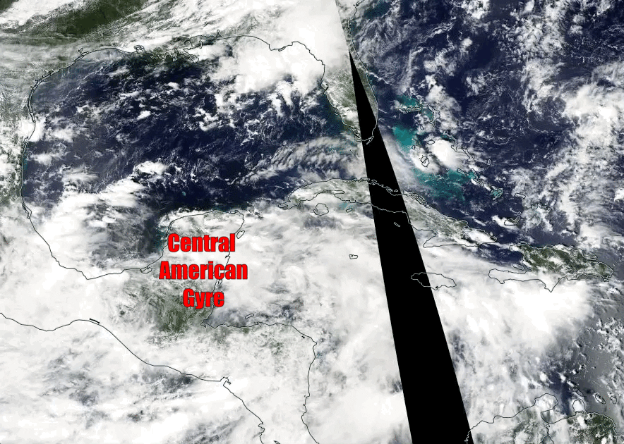
A developing gyre over Central America extending from Pacific to Caribbean will drive an increase in moisture across a large area.

Credit: weather.com
The overall environment is in good shape this year with cooling east equatorial Pacific waters and very warm Caribbean, the Caribbean becomes a natural incubation area for late season tropical cyclone development.
Water temperatures across the eastern equatorial Pacific have taken a tumble since July, favoring Atlantic tropical activity. #LaNina Watch pic.twitter.com/00Pd1g6RFM
— Michael Lowry (@MichaelRLowry) September 28, 2017
Elevated risk for tropical disturbances across the western Caribbean, Gulf, & Florida driven by La Nina-like VP dipole during October. pic.twitter.com/677wDUa0xk
— Ben Noll (@BenNollWeather) September 29, 2017
The 30-day rain anomaly illustrates the tropical risk- above normal in west Caribbean, then a few plumes: toward central Gulf, FL, south TX. pic.twitter.com/5UnLlSyjtE
— Ben Noll (@BenNollWeather) September 29, 2017
From weather.com
What’s a Central American Gyre?
Computer model guidance indicates a large Central American gyre will form in the northwestern Caribbean Sea and far eastern Pacific in the first week of October.
(MORE: Why Floridians Should Worry About the Tropics in October)

Possible setup for the development of a tropical entity during the first week of October.
Nearly all gyres of this fashion produce heavy rainfall over Central America and the western Caribbean Sea.
The main impact will be a surge in deep tropical moisture that computer guidance suggests could bring heavy rainfall to parts of Florida, Cuba, the Bahamas and the Cayman Islands toward the end of the first week of October. It is too early to say exactly how much rain will fall and what spots will see the most rainfall.
This gyre isn’t even expected to form until the middle or end of the week, and we’ll know a lot more about the forecast once we have a weather system on which to focus. There is no guarantee that a tropical depression or storm will eventually form from this gyre.
Heading into October, environmental conditions over the western Caribbean Sea are looking favorable for development – whether tropical cyclone formation happens with this system or down the road.
Water temperatures near the surface are currently in the mid- to upper 80s, about 2 to 5 degrees above average in the western Caribbean Sea. Temperatures of 80 degrees are generally supportive of tropical storm or hurricane development.
(MORE: Here’s How a Borderline La Niña Could Impact the Rest of the 2017 Atlantic Hurricane Season)

Current sea surface temperatures
In addition to the warm surface temperatures, the warmth runs hundreds of feet deep in the northern and western Caribbean Sea and parts of the Gulf of Mexico. This matters because of the size of a typical gyre like this one, which can stretch as large as 1,000 miles across. Larger systems tend to “eat up” more heat content as they traverse an area, so the more heat available to these systems, the longer they can prosper.
This bathtub-like water has been relatively untapped this hurricane season. The last tropical system to pass through this area was the dormant tropical remains of Harvey in late August as it passed through the entire Caribbean, but that system did not use much, if any, heat from this area. Before that, Tropical Storm Franklin formed in the western Caribbean Sea in early August.
Plenty of deep, tropical moisture will also be available for a tropical entity to use in thunderstorm development.
Whatever forms in the western Caribbean Sea may have to battle with wind shear in the southern Gulf of Mexico or western Atlantic Ocean, but again, it’s too early to determine the magnitude of this tropical deterrent.
(MORE: September 2017 Was the Most Active Month on Record for Atlantic Hurricanes)
There is plenty of time to watch this situation the next several days. Check back with weather.com for updates.
More on Central American Gyres
These gyres most often form in the late spring and early fall, when cold fronts become uncommon in this region of the world. They’re most common in September, but can be a source of tropical storms and hurricanes into November, and as early as May.
We typically see up to two gyres like this one set up each year, and they can spawn tropical storms in both the Atlantic and East Pacific basins, sometimes in each basin at the same time. Not all gyres produce tropical cyclones, but they all produce heavy rainfall.
Roughly 50 percent of Central American gyres have a tropical cyclone associated with them, according to Philippe Papin, Ph.D. candidate at the University of Albany. “When a tropical cyclone does occur, it tends to form on the eastern side of the [gyre] and rotates counterclockwise around the larger circulation.”
Gyre-like tropical systems are much more common in the western Pacific closer to southeast Asia, where the monsoon plays a larger role in the weather.
A notable example of gyre-induced tropical cyclone formation occurred in 2010 when Tropical Storm Nicole formed just south of Cuba from the gyre in late September.
Nicole was a short-lived and ill-formed tropical storm that tried to cross Cuba. It brought heavy rain to the Cayman Islands, Jamaica, Cuba and portions of South Florida.
Satellite images showing the evolution of Nicole from a gyre, Sept. 26-29, 2010. (NASA/Aqua/MODIS)
Hurricane Stan in 2005 is another good example of a hurricane’s interaction with a Central American Gyre, according to Papin.
Following Stan’s dissipation over the mountains of central Mexico, it’s remnant spin became part of a larger gyre that caused heavy rainfall over Central America. While Stan’s direct circulation resulted in around 80 deaths, according to the National Hurricane Center, heavy rainfall resulting from the gyre took more than 1,000 lives across Central America.
Other examples include Tropical Storm Andrea (2013), Hurricane Ida (2009 – assist from the gyre), and Hurricane Patricia (2015 – assist from the gyre, not a direct result).


")


Recent Comments