>
Join The Conversation!
US LATEST
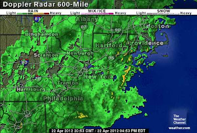
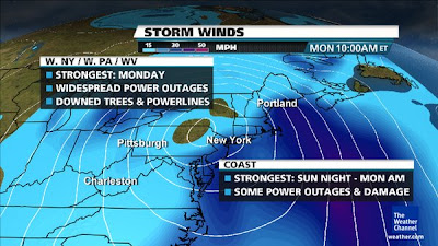
Biggest East Coast Storm Since October Set To Bring Drought Busting Rains 60-70 mph Winds, 1-2 Feet Of Snow To Appalachains
For frequent storm updates, follow on Facebook & Twitter!
Mark Vogan’s Storm Updates
– Now that the phasing has occured and upper low deepens, so the surface low deepens & on backside, watch for intense upward motion. This also enhances the storm’s cooling effect of air beneath which will help create conducive environment for snow.
– Pounding surf will likely cause minor beach erosion. Power may be out for OVER 2 million by 9am Monday morning.
– Upper low deepening, forces surface low to deepen. Winds to blow onshore at 50-65 mph tonight from Cape May, NJ northwards.
– Current Airport delays stand at 170 mins at Newark 105 mins for Philadelphia, 35 mins for LaGuardia, 15 mins JFK
– Heavy snows break out near Buffalo, NY tonight and work south through the overnight hours as air cools, storm cranks and pulls moisture around the circulation and well inland.
– The threat for power outages would be greatly reduced had it not been for a record warm March. Typically, many trees in Northeast are still bare or mostly bare at this time and so, they wouldn’t risk collapse
– Thankfully due to the drought situation throughout the Northeast, street flooding will occur, not river flooding
Latest Articles
Destructive Snowstorm Targets Interior Northeast
THE WEATHER CHANNEL
April Appalachian Snowstorm, I-80 Corridor Mess
ACCUWEATHER
Soaking, Flooding Rain in the East Today and Tonight
ACCUWEATHER
EUROPE LATEST
UK Trough Remains Anchored, Keeping Sunshine & Showers Going Into May, Series Of Lows Cross S, England
TWO ATLANTIC LOWS THIS WEEK TO SPREAD WIND AND RAIN ACROSS SOUTHERN ENGLAND
During this upcoming workweek we’re set to see not one but two Atlantic low’s push in over the far south of England and these will bring heavy rain accompanied by windy conditions with gales along the channel coast. Further north we’ll see more in the way of sunshine and showers.
The first low will push a front in as early as tonight across southwest England spreading east along with the low across southern England through Monday, existing off the Norfolk coast by tomorrow night but it will have influence on Tuesday over eastern areas. All in all it looks a rather dreary day with periods of rain along with a blustery wind blowing in off the channel which will make it feel quite raw if your out and about. Unless in the form of showers, the rain should remain south of Birmingham, perhaps Coventry on Monday
The continuation of sunshine and showers will be had from the Midlands up through Scotland, NI and Ireland but like we’ve seen over the past 10 days or so, showers will develop as the surface heats up but they may be a little more spaced out allowing many see lengthy spells of warm April sunshine.
TUESDAY: FOCUS OF SHOWERS OVER E. UK FROM LONDON TO SCOTTISH BORDERS
Tuesday sees a drier south of England while more persistent showers are possible over eastern England from eastern suburbs of London up through E Anglia, Lincolnshire, Yorkshire extending up over the Scottish Borders. Elsewhere it’s once again a day of sunshine and showers with decent spells of sunshine over western areas which escape the showers.
WEDNESDAY: ANOTHER LOW SPREADS WIND AND RAIN ACROSS S. ENGLAND UP INTO THE MIDLANDS, SHOWERY OVER E SCOTLAND
With the next low spreading into southern England during Wednesday we may see heavier, more organised rain than with the system moving in tonight. Alogn with heavier and a more organised canopy of rain we see a more northerly extent, spreading rains up through Birmingham but likely staying south of Manchester. Wind are likely to be stronger with possibly gales spreading slightly inland from the coast as the system will be deeper than tonights.
Elsewhere, showery rain will keep eastern Scotland somewhat damp and fairly cloudy while central and western Scotland down through northern England across to NI and Ireland should stay mainly sunny with scattered showers.
THURSDAY: A WINDIER DAY FOR MOST WITH MORE FREQUENT OUTBREAKS OF RAIN ACROSS A BROADER AREA OF THE UK
Like the early week system, the Wednesday system will exist off Norfolk but push northeast, keeping close enough to the UK for influence of both rain in shower form and fairly strong winds out of a northeast direction. This NE wind will keep it chilly, especially in eastern areas and wettest here too.
NEXT WEEKEND SEES SURFACE HIGH BUT UPPER TROUGH KEEPING SUNSHINE & SHOWER REGIME GOING INTO LAST DAYS OF APRIL/FIRST DAYS OF MAY
Following the exist of the second low by Friday, the organised rain and wind will be gone with with surface high pressure returning an upper low pressure remaining firm over the UK/Ireland, this keeps the sun and shower activity going and will lead us into the month of May.
THE EXTREMES OF THE DAY
TODAY’S US EXTREMES
COURTESY OF ACCUWEATHER
HIGH: 113° at Death Valley, CA
LOW: 16° at Atlanta, MI
TODAY’S UK EXTREMES
COURTESY OF THE MET OFFICE
HIGH: 60° (15.9°C) at St James Park (London)
LOW: 30° (-1°C) at Katesbridge (Co Down)
TODAY’S EXTREMES HERE AT MY HOUSE
HIGH: 53°
LOW: 40°
Thanks for reading.
-Mark


Recent Comments