>
Join The Conversation!
LONG RANGE VIDEO NOW AVAILABLE (SCROLL DOWN)
Today’s Global Weather Headlines
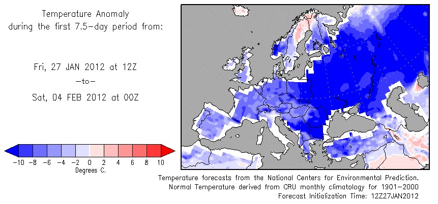
Europe Latest
European Cold Wave Starting to Take It’s Course, Seen Back On Christmas Day
In tomorrow’s post I shall provide you with forecasted ‘coldest high’s for the upcoming week across European cities…
US Latest
It May Be Mild Now And In Coming Days, But Push a Ridge Into Alaska And That Brutal Cold Will Head Straight For Lower 48!
Up until now, those of you who love the snow and cold weather, this winter has been somewhat of a dissapointment right?

The above chart from AccuWeather sums it up well with the winter so far with milder air more dominant than cold overall, however, it hasn’t been all doom and gloom as we have seen a few decent shots of arctic air spill south from Canada thanks to a ridge piercing the dominant Alaskan trough which has allowed an open door for this very cold air to spill south into Canada and the Lower 48. The couple of short lived, modest cold spells first hit the Rockies with a deepening trough, but because of the still-progressive nature of the pattern, the arctic air has’nt been allowed to stick around but more hit and then kick out east as ridging has always wanted to build in behind, pushing the cold pool out.
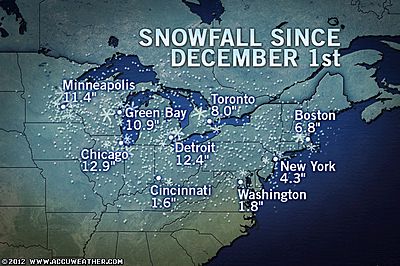
This frustrating, teasing pattern has meant a vastly different snow year from last year and the year before. Of particular note, check out the little snow for the Big cities of the I-95.
Yes, there has been plenty of wet weather but the lack of cold has meant lack of snow whereas the past two winters saw an abundance of cold, arctic air and a persistent storm track which brought multiple big hitting snowstorms.
So, what’s the difference this year to the past two?
.png)
The two above charts show the reason for the ‘lack of winter’ not only for the East, Midwest but for the majority of the northern hemisphere.
For cold and snow to have big impact on the USA, the Arctic Oscillation (below chart) must generally be negative, notice it’s not only positive but it’s strongly positive and it has been persistent. That has meant a stronger polar vortex over the pole, and a strong jet across the mid-latitudes. Like in Europe, a strong Pacific/Atlantic jet means persistently stormy, wet and mild with strong oceanic flow bringing mild air across the continents and the bottling of all the arctic air well to the north.
For the East to see cold and more importently (for some), snow.. the above chart which looks at the North Atlantic Oscillation and this, like the AO needs to be negative. When it’s negative, it tends to allow the building of high pressure (blocking) east of the US and over the North Atlantic and Greenland, by doing so, this blocks the general west-east flow at the mid-latitudes, forces warmth north into the arctic and cold, arctic air south into the mid-latides. What is key though is that the position of this high over the North Atlantic and Greenland means troughiness in the Eastern US and also over Western Europe. By driving a deepening trough into the Eastern US, it opens the door to arctic air (if the AO is negative too) and so, the cold air becomes available, secondly, the positioning of the trough is also key and the jet needs to dip south near to the Gulf in which it can tap energy for storm formation and with warmth and Gulf moisture involved and a jet roaring north UP THE EAST COAST, this often allows strong and powerful Nor’easter development. The past two winters has seen this perfect setup unfold and therefore major, record-breaking snowstorms resulted!
DO WE SEE A CHANGE TO A MORE FAVOURABLE PATTERN DOWN THE ROAD?

Well, I believe so and i’ll explain why.
The computer models for the best part of 2-3 weeks now has seen an eventual flip from positive into negative in both AO and NAO. This if trends are persistent would tell me that a change in the largescale pattern eventually was likely.
The AO has gone negative and we’re seeing the evidence of this with the cold building westwards into Europe. At the same time, I am keeping a close eye on Alaska. Noticed it’s getting colder and colder? Fairbanks neared 50 below zero this morning and there was temps around 60 below elsewhere in the state.
Models have showed a return to ridging up into Alaska and my concern for the Lower 48 in perhaps 10 days from now is that the cold that’s just getting colder across the Last Frontier may all of a sudden get replaced by a Pacific hopse of warmth and all that brutally cold air heads doe southeast into the Plains and eventually the East.
The NAO has been forecasted to go negative for sometime now and therefore with a southward plunge of brutally cold Alaskan air, possibly intensified further by a cross-polar Siberian injection, we could not only see the return of cold, locked in, over the Plains and East but it could be a major arctic outbreak which sparks a major lake-effect event before the freezing over of the Lakes as the cold intensifies but also we may see a series of East coast Nor’Easters with one big daddy which shuts down the major cities.
Finally, you notice the dip into negative on both the AO and NAO, we’re seeing the effects now with cold surging across Europe and with the building of severe cold over Alaska, the stage is set for the 10-20 day period which I believe will turn very interesting come mid-February.
Alaska Is BONECHILLING COLD!

Another frigid morning in Interior Alaska; ice fog advisory issued
DAILY NEWS MINER
Clipper Snow for the Great Lakes and Northeast
ACCUWEATHER.COM
Another Mild Surge to Impact the East by Midweek
ACCUWEATHER.COM

Asia Latest
5.5 Earthquake Hits Central Japan
FIRSTHAND WEATHER
Canada Latest
More snow targets Ontario, Quebec
THE WEATHER NETWORK
THE EXTREMES OF THE DAY
TODAY’S US EXTREMES
COURTESY OF ACCUWEATHER
HIGH: 84° at Lake Forest, CA
LOW: -19° at Stanley, ID
TODAY’S EXTREMES HERE AT MY HOUSE
HIGH: 38°
LOW: 23°
Thanks for reading.
-Mark


")


Recent Comments