>FOLLOW THE BLOG ON FACEBOOK & TWITTER AND CLICK LIKE/FOLLOW FOR REGULAR LOCAL, NATIONAL AND INTERNATIONAL WEATHER UPDATES, LINKS & MORE!
TODAY’S TOP WEATHER STORIES
On Weather & Climate Through the Eyes of Mark Vogan
Flood Unease Builds South Along the Mississippi
FOX NEWS
Forbes’ Five: Worst U.S. Tornado Outbreaks
THE WEATHER CHANNEL
Rain, Chill Add to Misery of Tornado Victims
FOX NEWS
US tornado outbreak was ‘biggest ever’
BBC
TODAY’S WEATHER ACROSS UK & EUROPE By Mark Vogan
Rain progresses through Northern Ireland, Scotland, NW England on Thursday after long dry spell, warmer air comes with it!
While going by the above graphic which is for this upcoming Friday, you can see that according to the European, we have building heights pushing up from Iberia and this will help push highs towards the weekend into the low 20s C across southern, perhaps even central England while the Scottish Southern Uplands and Central Lowlands could push 19 or 20C.
Ridging and warmth returns to central Europe and Scandinavia after sharp cooldown of late
Though the low remains strong and stuck off Ireland, ridging continues building through Sunday with a high pressure core centered over Germany which appears to push heat up through central and eastern Britain, France, Belgium, Holland all the way up into southern Norway and Swweden. Heights may be slightly lower across western areas of the UK and Ireland, thus holding temperatures down slightly more than further east. The east will be able to warm thanks to little ‘easterly wind’ and more of a warming southerly wind flow.
While Hawick, Edinburgh, Perth, Aviemore, Aboyne and even Aberdeen in eastern and central Scotland may reach 20-21C (going by the below map) further south Greater London may get back into the pre Easter heatwave territory of 25-27C.
As always, these maps this far out are always likely to change, so this is merely taking a look at the models and talking about what it’s telling us…
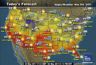
TODAY’S WEATHER ACROSS AMERICA By Mark Vogan
US Airspace Quiet on the whole!
It’s a rainy, dreary day in the Northeast, warming up again in the Plains!
WEATHER TALK
By Mark Vogan
Extreme Heat intensifies across African Sahel/Sub-Sahara as high intensifies, expands west to east, while North Africa remains comfortable, for now!
The below graphic is for Sunday. The 24C temperature at 5,000ft is very expansive. Where the dark purples are, this may have 32C temperatures at the 5,000ft level and thus we may be looking at temperatures of 47-50C over the weekend in the dark purple area, that’s 117 to 122F!
Middle East growing hotter too
Simply by looking at the above graphics, the Middle East Deserts which include such countries as Saudi Arabia, Iraq, Iran, Oman, Qatar, Yemen, UAE, Kuwait, Bahrain, Israel and Jordan for the most part have seen temperatures in the 80s and 90s with showers and thunderstorms coming and going. The more classic hot spots have been climbing gently into the low 100s. Well, over the coming 4 to 6 days, skies will see the demise of clouds and showers and the sun will grow punishing as high pressure intensifies, like over the Sahel and Sub-Sahara and this will boost temperatures from Baghdad’s 80s and low 90s to low 100s by this weekend into next week. The warmer cities such as Basra, Iraq (hotter than Baghdad) may see over 110, perhaps 113 degrees if Baghdad soars to 102-104 degrees by next Monday or Tuesday. Riyadh in south-central Saudi Arabia where it’s been in the 90s, well highs will likely top 104 by the weekend, 106 to 108 by early next week. This building of heat is expected by now and it’s only going to get hotter and hotter across the deserts of the Middle East.
The core of heat centered across NW India and Pakistan where it reached at least 113 degrees at Jacocobad, northern Pakistan this afternoon will eventually ease as the monsoon kicks in. This monsoon wind shift eventually shifts the hottest air in Asia westwards to the Middle East at generally the same time, the high lifts from the Sahel to Sahara, ultimately shifting the rains to where it’s currently hottest of Africa. The sub-Saharan region’s dry season should end by later this month or early June as the band of low’s and the hurricane baring ITCZ levels off at it’s summer position which will open up the 2011 Atlantic Basin Hurricane Season.
WHAT’S REACHING TODAY’S BLOGS?
UK Has Warmest April in Modern Record
Jim Andrews, International Expert, AccuWeather
Less Severe, But Not Quiet
Joe Lundburg, AccuWeather
What Is Up with La Nina?/2011 Pacific Hurricane Season
Ken Clark, Western Expert, AccuWeather
WHAT’S ON TODAY’S WEATHERBELL BLOGS?
Stupid Weather Tricks ( By Me)
Joe Bastardi’s Blog, Weatherbell.com
After the deluges comes the river flooding
Joe D’Aleo’s Weatherbell.com
THE EXTREMES OF THE DAY
TODAY’S US EXTREMES
COURTESY OF ACCUWEATHER
HIGH: 101 degrees at Yuma, AZ
LOW: 13 degrees at Big Piney, WY
TODAY’S EXTREMES HERE AT MY HOUSE
HIGH: 62 degrees
LOW: 30 degrees (Frost)
Thanks for reading.


Recent Comments