>FOLLOW THE BLOG ON FACEBOOK & TWITTER AND CLICK LIKE/FOLLOW FOR REGULAR LOCAL, NATIONAL AND INTERNATIONAL WEATHER UPDATES, LINKS & MORE!
TODAY’S TOP WEATHER STORIES
On Weather & Climate Through the Eyes of Mark Vogan
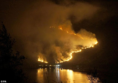
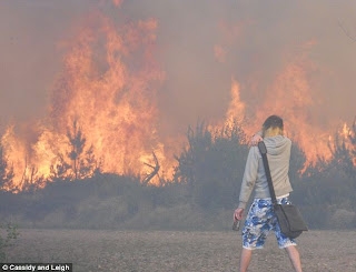
Wildfires Char UK landscape
NO IT’S NOT TEXAS OR CALIFORNIA, IT’S THE UK’S TURN NOW!
IT’S IRONIC THAT THESE FIRES HAVE REALLY FLARED DURING THE TIME WHEN IT’S A BANK HOLIDAY WEEKEND AND THE WEATHER WILL BRING FOLKS OUT WITH THEIR BBQ’S, CIGARETTES GLASS BOTTLES, HUMAN CAUSED? MOST LIKELY, DELIBERATE? ON THE WHOLE, PERHAPS NOT?
THE CREATION OF A TINDERBOX: MARCH STARTED IT WITH DRIEST MONTH IN 50+ YEARS, APRIL FINISHED IT OFF WITH WARMEST MONTH ON RECORD
1) A Prolonged dry spell starts the overall drying process.
2) A month of warm temperatures forces an excellerated rate of evaporation within the vegatation as well as ground, creating a key difference between dry, tinder dry and fire fuel!
3) On the heels of a record warm month, we found ourselves in an unusually dry air mass, this was evident with the cold nights and lack of morning dew.
4) To top it all off came warmth, sunshine, a strong, gusty wind and a bank holiday in which many take out the camping equiptment inluding the cigarattes, glass bottles and BBQ’s.
It’s ironic that all these fires really kick off AFTER the long bank holiday weekend. Nice weather = more folks outdoors and more folks outdoors means higher risk of a human caused spark!
OTHER ASPECTS WHICH CREATED THE PERFECT NW HIGHLAND BLAZES
While it was record breaking heat across the South with the warmest April 6th on record, it was raining gangbusters over the NW Highlands, combine this with mild temperatures meant an increase in vegatation growth in the area. Then came the absense of rain and very warm temperatures more suitable for June or even July. At this point, late April, the South of England was recording the hottest April day of any year, since 1949 with 27.8C (82 degrees F) reported at . In recent days, winds have been howlling at times, likely to gale force with 45 mph gusts. This as well as recording the warmest highs in all of the UK in the 19-22C range and an unusually dry airmass for this region all played crucial roles in all this.
After the sun, the fires: Record-breaking dry spell fuels huge moorland blazes across UKCrews continue battle with Highland wild fires
DAILY MAIL
Wildfires continue to rage in Highlands
STV
Scales of wildfires ‘unprecedented’
BELFAST TELEGRAPH
IN OTHER NEWS TODAY?
The Katrina of tornado outbreaks
STU OSTRO’S BLOG, THE WEATHER CHANNEL
Rare Severe Weather Event Strikes Hawaii
ACCUWEATHER.COM
New Zealand Tornado Rips Auckland
ACCUWEATHER.COM
Tornado rips through Auckland
BBC
TODAY’S WEATHER ACROSS UK & EUROPE By Mark Vogan
UK to see one more sunny day before a change while wet weather pulls away from Spain and Italy but it remains unsettled across Greece, Turkey and into W. Russia
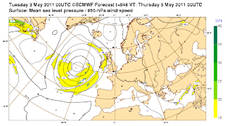
The western areas of the UK AFTER tomorrow will begin to see more cloud and eventually rain move in along a front nudging in off the Atlantic, this will mark the end (for now anyway) of the stunning brilliantly clear and sunny skies we have enjoyed and gotten use to. Wednesday will bring one more of those days before that change and for Friday and Saturday, well it looks fairly rainy, though I do think this may be more showers than a constant rainfall. However, I think we could actually use a little rain, couldn’t we?
As pressures have lowered at 5,000ft, this shows the air has gotten colder and tonight, under clear skies and as winds ease once the air cools off. This colder air aloft will sink to the surface aloowing stronger radiational cooling and even towns and cities in both Scotland and northern England may dip to 1 or 2C with outlying areas dipping to -1 or -2C. Highland Glens could see lows as cold as -5 or -6C. Impressive nighttime lows for May 4.
As for southern England, well this rain and dullier weather may hold off somewhat and as an actual fact, we’re going to see London rise towards 22 or even 23C as we head towards the weekend.
Spain which has been dominated by very dissapointing weather of late with plenty of heavy rain showers and generally cloudy conditions, producing highs only in the 17 or 18C range even in typically warm, sunny Costa Del Sol, well those skies are set to become much more sunny in the next day or so with highs rebounding into the 25-26C range in the south and 24-25C around Madrid. As for Italy, skies clear out here too but Greece, Turkey and into Western Russia, it remains cool, cloudy and showery.
Scandinavia also remains cool with hill snow and in central and northern areas of Norway, Sweden and Finland, snows will fall down to low levels as well as temperatures struggling to top 2 or 3C.
TODAY’S WEATHER ACROSS AMERICA By Mark Vogan
Front finally gets to Appalachains and Interior East Coast, clears rain-soaked Lower Midwest, tornado stricken Deep South!
The atmosphere throughout the Plains has been stripped clear of heat and storms, finally! but you always know this can’t last. The heart of the tornado ranaved region of Mississippi, Alabama, NW Georgia up into Tennessee will enjoy lots of sunny skies and temperatures only in the 60s, making it very pleasant for today’s cleanup operation.
Even now, as the front sweeps into the Appalachain Range and interior Mid-Atlantic and Northeast where severe weather is possible, back west and within the cleaner, more refreshing air, from North Dakota all the way down to South Texas, the air is warming up quickly. Yes it’s that time of year… see today’s forecast graphic below…
NEXT WEEK: TEXAS TO RETURN TO BLOWTORCH, COLD AIR DIGS INTO NORTH AND NORTHEAST, STORM TO SLICE IN BETWEEN CREATING POTENTIAL FOR ANOTHER BIG SEVERE WEATHER OUTBREAK
The pattern suggests more storms and a possible big severe weather situation next week as well as some very hot weather rebuilding back into Texas from Mexico before the next system develops.
Mid Atlantic-Northeast Soaker
With a low traversing the frontal boundary, now drapped across the Appalachains, heavy downpours with embedded storms will erupt throughout the area. Though rains will get into New York City, Atlantic City and Norfolk, it’s points inland, such as Allentown, Philadelphia, Harrisburg, Baltimore, DC and down to Charlotte where heavier downpours and the potential for strong to possible severe thunderstorms later this afternoon which could be triggered by temperatures crepping into the low 80s. Areas closer to the Atlantic Ocean, encluding Atlantic City, Toms River, New York City, it should be more showery rains but the odd isolated storm could roll in but the ‘severe’ risk is little to non. Tomorrow however may be a different story!.
WEATHER TALK
By Mark Vogan
‘Heat ‘n Hot Places
Comparing Hottest Temperatures of April 2010 with 2011
City/Country April 2010 April 2011
Islamabad, (Northern Pakistan) 111 degrees 98 degrees
Hyderabad (Central India) 109 degrees 109 degrees
Jaipur (North India) 113 degrees 106 degrees
WHAT’S REACHING TODAY’S BLOGS?
Severe Storms from Pennsylvania to Virginia; Maybe a Tornado Mixed In!
Henry Margusity, AccuWeather
Weaker Storms through the Week
Joe Lundburg, AccuWeather
Significant Pattern Change by Next Week
Brett Anderson, Canada Expert, AccuWeather
WHAT’S ON TODAY’S WEATHERBELL BLOGS?
It’s a Dirty Job, But Someone’s Got To Do It. ( Debunking the Global Warming propaganda on the recent Southern Tornado Outbreak)
Joe Bastardi’s Blog, Weatherbell.com
Corn and Wheat Woes Continue
Joe D’Aleo’s Blog, Weatherbell.com
THE EXTREMES OF THE DAY
TODAY’S US EXTREMES
COURTESY OF ACCUWEATHER
HIGH: 98 degrees at Anahiem, CA
LOW: 9 degrees at Leadville, CO
TODAY’S UK EXTREMES
COURTESY OF THE MET OFFICE
HIGH: 64 degrees (17.9C) at Porthmadog (Gwynedd)
LOW: 22 degrees (-5.3C) at Braemar (Aberdeenshire)
TODAY’S EXTREMES HERE AT MY HOUSE
HIGH: 63 degrees
LOW: 37 degrees
Thanks for reading.
-Mark


Recent Comments