>FOLLOW THE BLOG ON FACEBOOK & TWITTER
TODAY’S TOP WEATHER STORIES
On Weather & Climate Through the Eyes of Mark Vogan
USA CLIMBING OUT OF THE BITTER DEPTHS OF WINTER!
A LOT LESS COLD OVER MAJORITY OF SOUTHERN PLAINS THIS MORNING, MAJOR WARMING BEGINNING TO TAKE HOLD!
Check This Out!!!
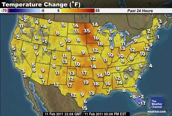


COLDER OVER SOUTH-CENTRAL REGION: Little Rock, AR 10 degrees, Memphis, TN 11 degrees, Nashville, TN 8 degrees, Houston, TX 24 degrees
Coldest Air Of This Winter To Grip Eastern Europe
AccuWeather News
Earthquake Off Chile Coast Friday Afternoon
AccuWeather News
Tropics Come Back To Life Near Australia
AccuWeather News
Harsh Winter Challenges Construction Projects
AccuWeather News
TODAY’S WEATHER ACROSS SCOTLAND & UK
TODAY’S WEATHER ACROSS AMERICA
From AccuWeather
Coming Shortly!
WEATHER TALK
By Mark Vogan
WEATHER HEADLINES TRANSITION FROM EXTREME COLD TO VERY WARM WEATHER SPEADING ACROSS A LARGE CHUNK OF USA MID TO LATE NEXT WEEK.. WARMEST CONDITIONS MAY CENTER OVER AREA THAT SAW COLDEST!
State record snowfall
OK News
Less Cold from Chicago south to Tulsa, Oklahoma City, Amarillo and Dallas but Colder For Little Rock, Memphis Nashville and even Houston! IT’S ALL ABOUT THE BLOWTORCH THAT’S FAST APPROACHING!
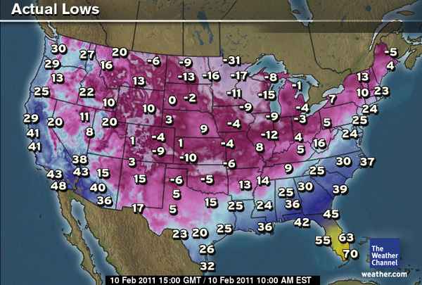
Little Rock just misses out on first single-digit low in 15 years!
As the huge turnaround has commenced and actually started right after those frigid numbers were achieved yesterday morning, temps didn’t get as cold across much of the Southern Plains this morning as temps rebounded nicely yesterday and with a less cold atmosphere, overnight readings didn’t fall to near the levels seen 24 hours earlier but not only that, we’re seeing warmer air flow across the Rockies and onto the Plains, a classic chinook wind is in progress, though because snow lies deep in many areasm it’s a step by step process, not an instant one. However by the time we get to next Wednesday through Saturday, the waiting process of climbing out of the pit will be well worth it as 70s spread from Houston to perhaps as far north as Valentine, Nebraska with 80s across a large swath of central and western Texas.
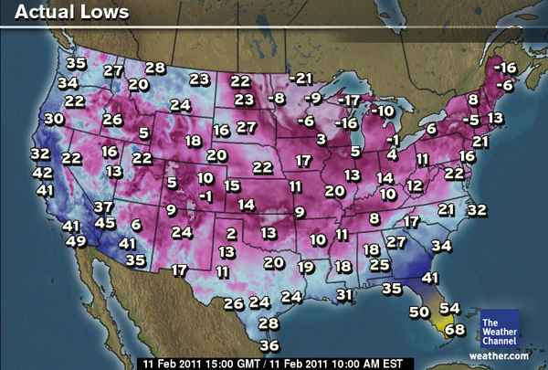
Still despite readings across much of central, northern Texas and particularly Oklahoma and Kansas some 10 to as much as 20-degrees warmer it was still a cold start this morning with 3 at Amarillo (-6 yesterday), 13 at Oklahoma City (-5 yesterday) and some more modest subzeros over the 20+ inch snowpack across the north of the state and southern Kansas. Indeed this would be classified as a very cold morning in this region but it’s got to be said that it’s not too bad when compared the the previous 48-hours and certainly folks who survived yesterday morning will and can suvive this morning.
Today’s 40s and 50s from central Texas northwards into Oklahoma, Kansas and even Nebraska will build warmer and warmer through the weekend and more so NEXT WEEK where 80s should build across a large chunk of Texas, 70s in Oklahoma and Kansas and 60s up through Nebraska and even South Dakota. WHAT A CHANGE!
WHAT’S THE REASON BEHIND THIS HUGE FLIP?
The large ridge built way up the west coast and shoving Pacific air all the way to Alaska has broken down and as a trough replaces this huge ridge and a powerful Pacific storm which actually transported the abnormally warm air northwards is replaced by a trough that’s pushing towards the US West Coast, meaning that actual ridge responsible for Alaska-like cold in the Southern Plains will be over the Heartland mid-next week and allowing sub-tropical heat to push north and helped by Pacific air blowing very strongly in from the West Coast and as those winds downslope the Rockies, they compress and warm.
The jet will FINALLY pull way north over MUCH OF THE LOWER 48 meaning though winter isn’;t done with the North of the country it could very well be for the Southern states… Welcome news I can only imagine!
VAGARIES OF THE WEATHER
INDIA & SUB-CONTINENTAL ASIA WEATHER
BY RAJESH KAPADIA
Sub-Continent:
True to estimates, Pakistan’s Balochistan and upper Sindh regions have started recieving precipitation today, Friday 11th. feb. F2 has arrived in the Sub-Continent !
Pakistan’s Northern regions can expect good snows on Friday night thru Saturday. Punjab (Pakistan) can expect some heavy showers measuring up to 40-50 mms in a day.
Upper Sindh, has already received rains on Friday and will continue to get more thru Saturday. Karachi can expect some rain on Sunday.
F2 will be moving into India on Saturday. Wait an expect heavy snow in Kashmir and H.P. and rains on Punjab and Haryana on Saturday evening/Sun.
The system will have an UAC trough dipping south from Central Pakistan almost into Kutch region on Mon/Tuesday.Hence, Vagaries estimates cloudy conditions and some light rain wll be the surprise factor for Rajasthan and Kutch on Mon/Tue.
And from Wednesday, the rain belt pushes into U.P. and Nepal.
Cold Northerly winds over the plains of NW India from Tuesday.
Partly cloudy weather for Mumbai on Wednesday/Thursday. A few degrees drop in temeprature later. Vagaries’ detailed forecast on Mumbai page.
click here to see our partner’s blog in full…
WHAT’S REACHING TODAY’S BLOGS?
Spring Fever Alert!
Joe Lundburg, AccuWeather
Video Update: Is Winter Really Over?
Henry Margusity, AccuWeather
Too Cold To Snow? Not Exactly.
Jesse Ferrell, AccuWeather
TODAY’S EXTREMES HERE AT MY HOUSE
HIGH: 41 degrees
LOW: 27 degrees
TODAY’S CONDITIONS (LOCALLY)
A CLEAR, CALM EARL OVERNIGHT PERIOD ALLOWED A SUBSTANTIAL FROST TO FORM AND TEMPS DIPPING TO 27 BELOW A GRADUAL REBOUND BACK ABOVE FREEZING AS CLOUDS AND THEN RAIN MOVED IN FROM THE SOUTH. AN OVERALL WET DAY WITH RAIN TO START, THOSE SHOWERS EASING BY LUNCTIME BUT HEAVY CLOUDS REMAINED. THE RAIN ONCE AGAIN RETURNED BY LATE AFTERNOON MAKING FOR A WET MISERIBLE EVENING.
Thanks for reading.
-Mark


")


Recent Comments