>See Weather & Climate Through the Eyes of Mark Vogan on Facebook and Twitter. What are you missing? Videos, Weather Info and promotional items which are NOT seen here on the blog! During your visit, click “like” and be a part of the blog.. thanks for reading and your support.
Haven’t seen my Winter Forecasts for the UK, Europe as well as US? CLICK HERE!
Today’s Top Weather Stories
On Weather & Climate Through the Eyes of Mark Vogan
50-100MPH WINDS, HEAVY RAIN, SNOW AND EVEN ICING PROBLEMS MAY EFFECT YOU TONIGHT AND TOMORROW IMPORTANT NOTE: See below, Mark Vogan’s in-depth break down of impact potential the strong Atlantic storm system may have on the UK Wednesday night/Thursday!
live news feed…
* As of 2am Thurs: aberdaron, wales reports sustained winds at 44 mph out of the ssw and a gust to 54 mph
* capel curig, wales reported a gust to 59 mph
* stark contrast over sout of england: st catherines point, isle of wight has sustained winds to 26 mph, gusts to 33 mph out of the wsw with a current temp at 52 degrees
whilst charlwood, surrey remains at 28 degrees and a wind at a mere 1mph
* As of 1am: sustained winds are now clocking 36 mph with gusts topping 55 mph at south uist
* aberdaron, wales now reporting sustained winds at 36 mph and gusts to 52 mph
* an interesting contrast, whilst plymouth, devon as of this hour is reporting sustained winds out of the sw at 33 mph and gusts topping 45 mph, the temp is up at 52 degrees (11.3C) whilst there is NO WIND being reported at charlwood, surrey and the current temp is at 28 degrees (-2.5C)
*As of 7pm: Across Northern Ireland winds are now averaging sustained winds between 10-15 mph out of the S,SW with temperatures of 42 degrees (5.3C) at aldergrove and 44 degrees (6.5C) at ballykelly
* stornoway, lewis is experiencing winds sustained out of the S at 24 mph with gusts to 34 mph, temp at 46 degrees (7.7C)
*aboyne, aberdeenshire is already down to 26 degrees (-3.3C)
UNITED STATES EXTREMES OF NOVEMBER 2010
Sierra Nevada-Rocky Mountain Snowstorm and cold to record, near record -breaking Midwest Warmth
Astonishing 70s make for a run at records and 20-degrees above normal, some spots are approaching 25 degrees above normal.
With a set of 69’s at Minneapolis and Chicago yesterday, as the front out to the west continues to creep it’s way eastwards, as it gets closer to both Minneapolis and Chicago, southerly winds may become more pronounced and as long as winds don’t turn slightly SE over Chicago, there’s every chance that O’Hare International Airport will read a 70 degree high or even tie a record of 71 degrees. Minneapolis may have seen it’s chance yesterday to reach 70 but there’s still that chance that conditions remain too perfect and even they may top 70 degrees this afternoon.
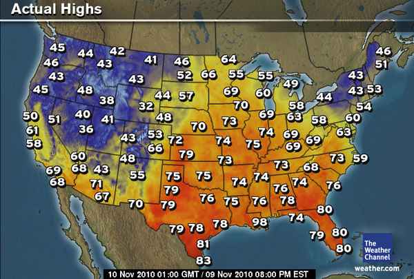
Whilst Buffalo Grove, IL touched 72 degrees and St Louis 75 degrees yesterday, there’s every chance both of these locales as well as many others that are away from the cool waters of Lake Michigan mau see highs top the mid-70s this afternoon and even upper 70s for St Louis.
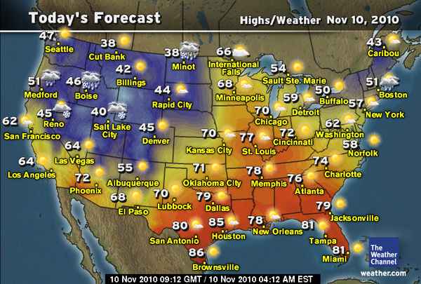
I hope you folks are enjoying these unusual late season temperatures because all that cold air is pushing eastwards, instead of upper 60s to low 70s you’ll see today, tomorrow will drop back to the still pleasant mid to upper 60s and by Saturday, the air that’s over the central Rockies will be positioned over these same areas enjoying the 70s. If you look at the Weather Channel map below, by Saturday Minneapolis should only top out around 41 degrees and Chicago 47 degrees. This numbers are colder than what the lows the past few mornings have been and as much as they appear cold, they’re near normal (Minneapolis 1-degree above normal and Chicago 3 below normal). This just shows how much above normal it’s been in both these cities.

BREAKING NEWS
GALE-WARNING FOR UK TONIGHT, WINDS ALREADY PICKING UP ALONG WEST COAST!
By Mark Vogan
After a frosty start, 40-degree high under wall to wall shine and a return to sub-freezing and frosty territory as darkness fell this evening, a deep Atlantic low is now sneeking it’s way in off the Atlantic and will reshape the weather picture over the next 4-6 hours. This new weather system will usher in strong and potentially damaging winds and heavy, flooding rains, the heavy weather will pick up through the overnight tonight starting with western areas of Britain. A heavy nation-long band precipitation will migrate west to east throughout tonight and with it and particularly behind this main band which will represent the leading front, winds are likely to turn dangerous as gales turn severe along the Irish Sea, North Channel and Atlantic coasts of the western UK!
Shipping is likely to be effected late tonight and throughout tomorrow as swells grow as sustained wind speeds intensify towards 30-40 mph out of the southwest. Major services between Northern Ireland and southwest Scotland are likely to be impacted as well as the Ullapool to Stornoway service. Most Calmac services between the inner and outer Hebrides are all likely to see services cancelled or severely disrupted (mainly tomorrow). The remotest isles in the path of dangerous, damaing winds are likely to include, Islay, Coll, Tiree, Mull, Rum Eigg, Canna and Muck as well as Skye and the outer Hebrides where gusts at their worst could reach 80-100 mph on the open, south and west facing coasts. The mainland of west coast Scotland, that’s exposed out of the southwest will see 60-70 mph gusts and even Fort William may see damaging gusts as southwest winds funnel up southwest to northeast oriented Loch Linnhie.
The higher peaks of the northwest, central and northern Highlands are all open to intense wind gusts and Cairngorm Summit, east of Aviemore may easily surpass gusts witnssed a couple of days ago which topped 113 mph.
As for the Central Belt, western areas will see winds and rain pick up earlier, say from Gourock to Harthill and will pick up more by morning further east beyond Harthill, all the way to North Berwick and up the east coast to Aberdeen and further on up to Wick and Dunnet Head, though Wick and Dunnet Head may already be very windy!
20 to 30 mph sustained winds may be likely for a time all across the Central Belt between Greenock and Edinburgh with gusts topping 50 or 60 mph. These types of winds may knock down a few trees exposed to west, southwest winds. Open, high up areas of Dumfries and Galloway as well as Ayrshire and Argyll will likely see damaging to trees and possibly some power loss as gusts may reach 70 mph in spots.
This combined with driving and at times intense rains will create nasty drivening conditions, severe surface water and of course some flooding.
HIDDEN DANGER:THE FROST WAS THERE, NOW IT’S NOT!!
A COLD 40-DEGREE DAY FEELS GOOD WHEN THERE’S 100% POSSIBLE SUNSHINE, IT’S STILL EARLY IN THE SEASON AND THERE’S NO WIND BLOWING!
Even at noon, my thermometer was still reading a chilly 37 degrees, up from 28 degrees which actually was achieved just around midnight as breezy conditions eased up. It remained at 28 all night thanks to some patchy cloud which moved in stopping the temperature from falling to my epredicted low of around 24 degrees. The noon reading today of 37 did make me wonder whether that was going to be my high, however thanks to literally no wind and perfect sunshine, the air did “warm” to 40 degrees, yes cool but it’s just that little bit early in the year yet and there was enough strength left in the sun to warm it tp a level 40 degrees for the high. Yes this air mass is cold but though the clocks have changed and we’re approaching mid-November, the air mass itself needs to be a little colder in order for the sun to not warm it up. Perhaps a little northerly wind blowing, may have helped the sun from warming the surface.
Early evening freeze comes and goes, quicker in some places than others, may have dangerous of it’s own, never mind the wind!
The stillness of the air and the not so stunning heating of the ground by day did allow a very quick cooling after dark and the temperature did drop back to 30 degrees as early as 5.30pm this evening allowing a decent frost to form on cars. However only a mere 1 and a half hours after the bottom dropped out, it’s now up to 36.5 degrees and rising!
I see little droplets already forming on my office window.. the problem now is that not only could the precipitation moving in from this system as it cuts into a cold air mass over Scotland fall as snow even down to low levels but ice and frosted ground may remain as the rains arrive, thus creating a danger of slippery conditions for the unsuspected pedestrian or icy roads may may cause crashes. Freezing rain is’n’t outwith the realm of possibility either.
Areas further east are going to see a very cold night because if my temperature can fall as fast as it did and as cold as it did here in such a short time (in a relatively western location), then a longer spell under clear skies will allow the temperature to drop much further before the Atlantic weather arrives. Some higher locations further east may see the coldest temperatures of the season for all of the UK, such spots as Braemar could fall to -6 or -7C before the precipitation arrives in from the Atlantic as snow and eventually turns to rain!
I believe anywhere away from the immediate coast has a chance of seeing a few snowflakes before the main band of rain arrives and the cloud thickens and covers a given area long enough to erode the cold air. Higher ground has an even greater chance at seeing not only a coating of snow but possibly a few inches. With heavy snow and strengthening winds, blizzard conditions may create havoc on some higher routes tonight. Eventually the Atlantic air will warm the air from top to bottom and eventually transitition it’s precipitation from snow to rain, even at higher elevations.
Today’s Weather across America
From AccuWeather
East Beautiful Weekend Weather, But Winter Has Tickets
By Alex Sosnowski, Expert Senior Meteorologist
Nasty Cold Thanksgiving Week 2010
By Alex Sosnowski, Expert Senior Meteorologist
Not a Missile Over California, It’s Simply….
By Henry Margusity, Expert Senior Meteorologist
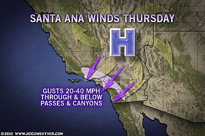
Santa Ana Winds to Howl This Week
By Meghan Evans, Meteorologist
Weather Talk
By Mark Vogan
A Year’s Worth of Temperature Records!
Yesterday marked exactly one year in which I have been recording the tempearture in my back garden here at my home in Lennoxtown, East Dumbartonshire, Scotland (approx 10 miles north of Glasgow city centre) I have lived here since May 2008.
The temperature on November 9th, 2009 was 45/27 and this day last year was 46/37.
Here is an interesting look back at some key temperature milestones in my first year of record-keeping.
WINTER MONTHS
The first sub-freezing night was in fact the first day of records (November 9th) with a low down to 27 degrees.
The first day in the 30s was November 28th, 2009 with a high of 36 degrees.
The first sub-freezing day was December 13th with a high of 30 degrees.
The first day in the 20s was December 22nd with a high of 29 degrees.
The first night in the 10s was December 23rd with a low of 17 degrees.
The first series of consecutive nights below freezing were November 28-December 1st (low’s of 30, 29, 30, 23 degrees)
The first series of consecutive days below freezing were December 22-26th (high’s of 29, 30, 24, 31, 32 degrees). 5 days in total without climbing above freezing.
The first and only day which remained in the 10s for a daytime maximum was January 8th, 2010 with a very cold high of 19 degrees. A day which saw ice fog linger, encasing trees, telephone wires and every outdoor object in thick hoar frost. This blanket of fog, filtered out the sun, therefore holding the chill in the air all day long.
The most consecutive nights which remained at or below freezing was 24 consecutive nights. From December 18th, 2009 through January 10th, 2010. The mildest of those nights was a 31-degree low on December 27th and a 32 degree-low on December 30th. The coldest was a bitter 13-degree low on Christmas Eve 2009 and an even colder 12 degree-low on January 8th, 2010.
EARLIEST AND LATEST OCCURANCE
The earliest and latest occurance of sub-freezing lows during last season (2009-10). The earliest was November 9th with a low of 27 degrees. The latest was May 11th, 2010. The earliest this season was September
The earliest and latest occurance of nights dropping below 20 degrees is December 23rd, 2009 for the earliest with a low dropping to 17 degrees. The latest was February 23rd, 2010 with a low dropping to 19 degrees.
The earliest and latest occurance where the high fails to get above freezing. The earliest was December 18th, 2009 with a high of 32 degrees and the latest being February 19th, 2010 with a high also of 32 degrees.
Highs
The longest streak where the temperature fails to reach 40 degrees. 28 days, stretching from December 17th, 2009 to January 15th 2010.
The longest streak where the high fails to reach 50 degrees. 77 days. November 24th, 2009 to February 9th, 2010
The longest streak where the high fails to reach 55 degrees. 138 days. From November 20th, 2009 to April 7th, 2010
Lows
The longest streak where the low drops to or below 35 degrees. 31 nights. From December 16th, 2009 to January 15th, 2010
The longest streak where the low drops to or below 30 degrees. 11 nights, from December 31st, 2009 to January 10th, 2010
The longest streak where the low drops to or below 25 degrees. 5 nights, from January 1st-5th, 2010
The longest streak where the low drops below 20 degrees. 2 nights. December 23-24th, 2009 (17, 13 degrees) and January 7-8th, 2010 (15, 12 degrees)
To be continued!
Vagaries of the Weather
India & Sub-Continental Asia Weather
By Rajesh Kapadia
Wednesday, November 10, 2010
The low over Saurashtra has now fizzled out. But I expect the clouding over Gujarat and North konkan to linger on till the weekend.
This is mainly due to the resultant UAC which will form over the region and persist for a couple of days.
Would expect more cloudiness than rain in the Gujarat /Mah region till the weekend. Light rains in some areas of the 2 states and South Rajashtan could be expected.Some residual precipitation may occur on the Sindh coastline (eastern end).
There were some queries regarding the estimated new system to form in the Bay. Vagaries is always cautious, and will chase and follow the projected low after it forms and enters the Andaman Sea. At the moment it is nowhere in sight !
In fact, for this weekend, I see the rains diminishing in intensity in the central peninsula and coastal A.P/North T.N. coasts.
What’s Reaching Today’s Blogs?
Models On How Cold Late November Could Be
Jesse Ferrell, AccuWeather
The Storm That Keeps On Giving
Joe Lundburg, AccuWeather
Some More Evidence of Indonesia Volcano. Plus.. Much Colder Weather Coming
Henry Margusity, AccuWeather
The Extremes of the Day
Today’s US Extremes
Courtesy of AccuWeather
High: 88 degrees at Port Isabel, TX
Low: 2 degrees at Big Piney, WY
Today’s UK Extremes
Courtesy of the Met Office
High: 53 degrees at Isles of Scilly
Cold High: 38 degrees at Spadeadam (Cumbria)
Low: 24 degrees at Machrihanish (Kintyre)
Today’s Extremes here at my house
High: 40 degrees
Low: 28 degrees
Thanks for reading.
-Mark


")


>This was a useful post and I think it is rather easy to see from the other comments as well that this post is well written and useful.
>Thank you very much for your thoughtful comment, and for taking the trouble to post it.Cheap Indy Gucci
Handbags