>See Weather & Climate Through the Eyes of Mark Vogan on Facebook and Twitter. What are you missing? Videos, Weather Info and promotional items which are NOT seen here on the blog! During your visit, click “like” and be a part of the blog.. thanks for reading and your support.
Haven’t seen my Winter Forecasts for the UK, Europe as well as US? CLICK HERE!
Today’s Top Weather Stories
On Weather & Climate Through the Eyes of Mark Vogan
BRITAIN SLAMMED BY WINTER!
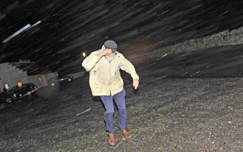
A man battles against the force 11 storm as he leaves a public meeting in Daliburgh, South Uist. The subject of the meeting was climate change Picture: Robert Perry (The Scotsman)
‘Worst storms for years’ sweep in
The Scotsman
Ferries hit as weather turns nasty
The Herald
Winter storms batter UK, with worse to come, say forecasters
The Guardian
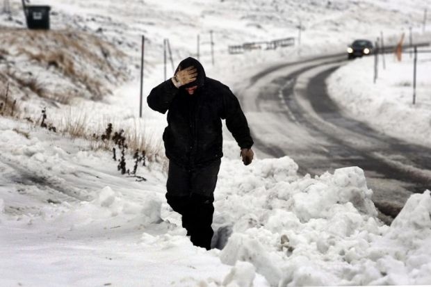
The arrival of snow caused the closure of several roads around the Glenshee Centre yesterday
Image Courtesy of The Herald
IN OTHER NEWS
Fair Weather for Towing Stranded Cruise Ship
AccuWeather News
Tropical Cyclone Threat to India Still Seen
AccuWeather News
Flooding Continues in Puerto Rico, Virgin Islands
AccuWeather News
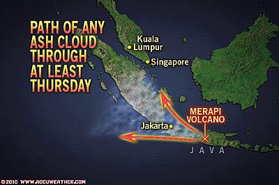
Merapi Volcano Still Has Potential to Disrupt Passenger Flights
AccuWeather News
Today’s Weather across America
From AccuWeather
Santa Ana Winds to Howl this Week
By Meghan Evans, Meteorologist
Travel-Disrupting Snow in Store for the Denver Area
By Meghan Evans, Meteorologist
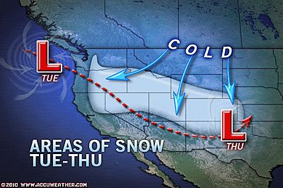
November Arctic Cold Blast Forecast
By Alex Sosnowski, Expert Senior Meteorologist
Cascades, Sierra Nevada Snowstorm Today
By Alex Sosnowski, Expert Senior Meteorologist
Weather Talk
By Mark Vogan
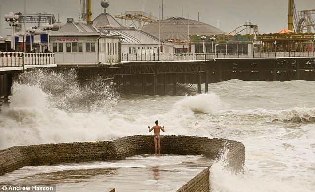
Bit chilly: Storms batter the coast at Brighton as 21-year-old Sebastian Riet, from Atlanta, Georgia takes in the view in some Union Jack underpants. Image Courtesy of the Daily Mail
UK Latest Weather
DESPITE A WIND STILL BLOWING, THE TEMPERATURE STILL DROPS, APPROACHING FREEZING AS OF 5PM!
After a very stormy night which blasted practically all corners of the UK with storm-force winds, flooding rains, heavy seas and heavy snow, today it’s more about the stinging winds blowing off the chilly waters of the North Sea and despite the storm clouds of the past couple of days and last night giving way to beautiful sunshine it felt darn cold with those strong east winds which continued to produce hill snow for Scotland, Wales and England. A “daytime high” only mustering 41 degrees here at my house isn’t so bad is it? but with that brisk, icy east wind blowing straight up the Firth of Forth and east to west across the Central Belt, it felt much colder than the 41. Interestingly the “actual” high managed to top 43 degrees between the hours of 12 and 2am this morning before falling to a low of 39, after that low was reached, the temperature by day only warmed to 41, therefore this means an “actual” high of 43 was achieved during the early hours and the “daytime high” was less than the actual high with 41 degrees..
GUST TO 113 MPH RECORDED ON TOP OF CAIRNGORM MTN
Damaging winds were reported anywhere from the Scottish Highlands to as far south as Devon. The deep low responsible for the flooding rains, heavy and disruptive snow and indeed wind spun it’s way southeastwards down over the UK, producing a respectible hurricane-force gust to 113 mph atop of Cairngorm Mountain, just east of Aviemore whilst a 65 mph gust was reported at Berry Head, Devon. Even southwest Scotland saw powerful winds with a gust topping 60 mph at Dundrennan, Dumfries and Galloway with minor roads reportedly closed across Dumfries and Galloway due to fallen trees.
As expected London after enduring the warmest night in November in 5 years and recent mid to upper 60-degree weather late last week, there was a biting wind funnelling up the Thames and into the capital as well as some hefty showers making it feel very much like November.
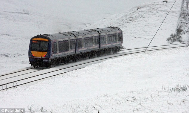
Snow journey: A train battles through the weather in Dalwhinnie in the Highlands of Scotland.
Image Courtesy of the Daily Mail
TONIGHT MAY BE COLD HERE BUT MUCH COLDER WHERE THERE’S NOW SNOW LYING! IT COULD GET TO -8C SOMEWHERE….
Though winds have now eased off here at my house and the temperature has now entered the 20s and may fall towards 24 degrees for a low here by morning. Where there’s snow to the north tonight and skies remain clear and winds lighten up, I am expecting the coldest values of the season so far. I expect somewhere to reach down to as low as -8C (18 degrees) tonight somewhere up north! Even some spots over England, up over the Pennines where snow may be lying tonight, it may get down to -6 or -7C perhaps if conditions remain good for radiational cooling, however clouds have rolled in over some areas to the north which have a decent amount of snow covering the ground, therefore the clearer skies further south over Perthshire and down here over the Central Lowlands may find that this area ends up colder than areas further north which have snow cover and without the snow covered ground, the national low may end up slightly milder, however somewhere like Tyndrum may still muster a -7 or even -8C tonight even without the snow on the ground as the air is certainly cold enough to support substantial overnight cooling, especially so, when daytime highs struggle to warm and the air mass is already cold, this helps enhance radiational cooling by night.
Another area which may see cold which may or may not be surprisingly strong, that is if there are areas of Dumfries and Galloway which saw the snow. Skies should remain clear and winds light enough that even the higher ground of southwest Scotland may even see tempeartures tonight reach the coldest values so far in Britain, the coldest so far officially is -6.6C I believe, though there were many reports of -7C!
Vagaries of the Weather
India & Sub-Continental Asia Weather
By Rajesh Kapadia
Tuesday, November 09, 2010
Where has the Northern Winter Dissappeared” ?
It came with a bang, and brought good early rain/snowfall to North India. But, winter is now whining, and seems to have lost all its nip and cold.
In the first week of October, as soon as the SWM started its withdrawal, the W.Ds held sway, and set about taking control of the Northern Sub-Continent. If you remember, the North had 2 good W.D., back to back, as soon as monsoon showed signs of retreating. Snow, rare first snows of October, was seen in Kashmir, and in the higher and lower ranges of H.P. Snow even blanketed the Gharwals in October.
And the temperatures started to fall in the Northern regions and Central parts. Lows of 10c were reached in Punjab and Delhi and Rajasthan started feeling the Northern winters.Hills plunged to freezing and below.
So far so good.
But then the SWM changed its mind and refused to go away. Staying put around the Mah. region. And not allowing the W.Ds to form.
In fact, the sytems from the bay started moving in, as if it was the monsoon time. The first depression of the season came in October !
Where’s the place for our W.Ds ?? Another system from the Bay forms a cyclone , and they carry on from the Bay.
Systems pushing up clouds and warm air into the Northern areas, instead of restricting themselves to the southern peninsula, and mocking the prevailing north-westerlies all the way. And its still on ! A remnant from “Jal” is moving right into Gujarat !
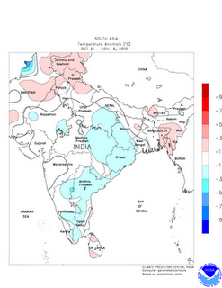
The temperatures are high for this time, the nip is all but gone and the snows have melted away. Its back to …not summer, but September climes for the Northern regions. Nights are up by 9cabove normal in places, like Allahbad..in fact all over its 6-8c above normal..check on the list here. Days are in the low 30s !
Last week’s temperature anomaly map shows it all.
Whats happeninig next? For the next 5 days, at least, I do not see any W.D. coming to “re-install” the winter in the Northern regions. Ok, I expect the days to drop a bit, by 1/2c, due to the seasonal shifting of the sun, but nothing really to write home about.
A real good strong W.D, is needed to bring the winter back, and I presume one might have to wait for and watch the track of another predicted system coming from the Bay.
Let’s hope for the Northerners (and Southerners), the system behaves normally, precipitates where its needed, in T.N.and not loose its way to the North!
See our partner’s blog HERE!
What’s Reaching Today’s Blogs?
Following the Surges of Cold
Joe Lundburg, AccuWeather
Nothing But Sunsets
Jesse Ferrell, AccuWeather
Back to the Plains and West for Snow… Video Talks about Cold Weather Next Week
Henry Margusity, AccuWeather
The Extremes of the Day
Today’s US Extremes
Courtesy of AccuWeather
High: 87 degrees at McAllen, TX
Low: -1 degrees at Bodie State Park, CA
Today’s UK Extremes
Courtesy of the Met Office
High: 55 degrees at St Catherines Point (Isle of Wight)
Cold High: 38 degrees at Braemar (Aberdeenshire)
Low: 32 degrees at Baltasound (Shetland)
Today’s Extremes here at my house
High: 43 degrees
Low: 39 degrees
Thanks for reading.
-Mark


")


>visitor of your website i will share it with my friends.versace shoes for men
Thanks.