>See Weather & Climate Through the Eyes of Mark Vogan on Facebook and Twitter. What are you missing? Videos, Weather Info and promotional items which are NOT seen here on the blog! During your visit, click “like” and be a part of the blog.. thanks for reading and your support.
Haven’t seen my Winter Forecasts for the UK, Europe as well as US? CLICK HERE!
Today’s Top Weather Stories
On Weather & Climate Through the Eyes of Mark Vogan

Photo Courtesy of CNN
Indonesian volcano spews more scorching ash; death toll reaches 156
CNN
Haiti ‘got very lucky’ as Tomas skirted island
USA Today
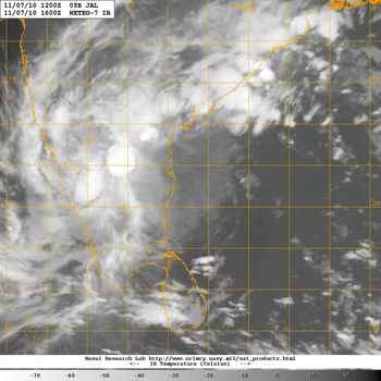
Jal Bearing Down on Southeastern India
AccuWeather News
Flood Threat Targets Dominican Republic, Puerto Rico
AccuWeather News

Today’s Weather across America
From AccuWeather
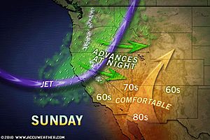
Weekend-Ruining Rain, Mountain Snow for West
By Katie Storbeck, Meteorologist
Rain, Wintry Mess, Gusty Winds Take Aim at New England
By Meghan Evans, Meteorologist
North Carolina Skiers Take to the Slopes
By Vickie Frantz, AccuWeather.com Staff Writer
Freeze Warning Issued for Interior Southeast
By Vickie Frantz, AccuWeather.com Staff Writer
A Pacific Storm to Bring Late-Week Snow from the West to the High Plains
By Meghan Evans, Meteorologist
Weather Talk
By Mark Vogan
UK Latest Weather
FEELING COLD AND RAW ACROSS MUCH OF UK THROUGHOUT THIS WEEK, MOUNTAIN SNOW IS LIKELY!
Last Week
MILD TO THE SOUTH, COOLER OVER THE MID PART OF BRITAIN, COLDER TO THE NORTH!
After a week which saw a north-south temperature divide with the Atlantic driven weather pattern. To the south, a well pronounced south to southwest flow of air flooding up from the sub-tropics brought the south of England the last gasp of warmer air as temperatures from Bristol, Oxford to Greater London were mild by night (mid to upper 50s) whilst by day it was warming into the low to mid-60s with a top temperature of 66 degrees at St James Park in the heart of London provided a feel of last glimpses of Indian-summer with folks likely strolling along Oxford street or in Hyde Park with a t-shirt. That’s iff it wasn’t raining of course!.
With slightly cooler air and more unsettled over Manchester, Liverpool and up to Carlisle, it was only in the mid to upper 40s over the Scottish Lowlands and upper 30s to low 40s over the Highlands. This was thanks to colder air over and to the north of Orkney and Shetland which bled south and down over the Highlands. The Highlands did however act like a barrier, holding the colder air to the north but also stopped milder air over England from advancing north.
At the same time, gales blowing out of the west blew continued along the coasts and up over the northwest Highlands.
This Week
SNOW LIKELY OVER MANY HIGH ROUTES OF SCOTLAND, EVEN OVER CUMBRIA, THE PENNINES AND SNOWDONIA, FEELING MUCH COLDER OVER LONDON AND THE SOUTH!
I believe this week may feel just like last for us here in the Scottish Lowlands whilst snow, which may well be heavy at times over Shetland, the Grampians, Southern Lowlands, Cumbrian Mountains, Snowdonia and the Pennines of central England. The potential is there for snow falling at below 1,500 feet which would mean the A9 in some sections may see snow and lying snow which could cause travel problems between Perth and Inverness. The main trouble spot I believe may be the section of A9 between Drumnochter Summit, Dalwhinnie, Newtonmore-Kingussie and up to Aviemore and Carrbridge as well as up over Slochd Summit near Moy. These areas mnay be the worst effected areas for the main travel routes but other roads such as the A95, A96 and many other higher routes which have snow poles along them are all going to be prone to snowfall today and through this week.
As for temperatures, the areas just mentioned may have a tough time getting above 40 degrees and down to near freezing at night, even if it’s cloudy and windy but if clear and winds light, we may see the coldest temperatures so far, especially if there’s snow on the ground!
Much of England and Wales will feel cold, especially in that wind and when it’s showery and only in the mid-40s.
The big shock will be to the south over the same areas which enjoyed those balmy 60s of last week. Since it was only 53 degrees for a national maximum at Milford Haven in Pembrokeshire today, this is a taste of things to come for the south with highs, even over central London perhaps only topping the upper 40s! What a difference to the mid-60s last week. Those upper 40s (7-9C) will feel even codler with a wind blowing!.
Vagaries of the Weather
India & Sub-Continental Asia Weather
By Rajesh Kapadia
Sunday, November 07, 2010
So Jal is the shortest lived category 1 storm ever to have crossed T.N. or most probably any where else. From Cat 1 to a DD in under 18 hours.
People will remember Jal at least for this record
Few hours back, the search was on for the “eye” of JAL, but now we are searching JAL !
Putting up the latest satellite image. And you can enter the “Search for Jal ” Quiz contest !
Moving inland , the low will precipitate dimnishing amounts of rain in interior T.N. with a bright Monday for Chennai. Rains will decrease from tomorrow afternoon in Bangalore. But showers will move into Mah, with south Mah. getting intermittent rains from tomorrow. Mahableshwar could expect some rains next couple of days.
Konkan will see precipitation next 2 days, as the swirl covers the region.
FOR GREAT INDIA, SUB-CONTINENT ASIA AND GLOBAL WEATHER NEWS
See our partner’s blog in-full HERE!
What’s Reaching Today’s Blogs?
Winter Hazard Awareness Week (and highs topping 60 through Tuesday!)
Paul Douglas Weather Column, WeatherNation Founder and Meteorologist
Parts of Tomas Back into New England; Storm in the Plains
Henry Margusity, AccuWeather
Still Watching Tomas; A Few Quiet Days Ahead
Frank Strait, AccuWeather
So The Weather Never Changes in Southern California-Debunking a Myth
Ken Clark, Western Expert, AccuWeather
The Extremes of the Day
Today’s US Extremes
Courtesy of AccuWeather
High: 88 degrees at Chandler, AZ
Low: 16 degrees at Elkader, IA
Today’s UK Extremes
Courtesy of the Met Office
High: 53 degrees at Milford Haven (Pembrokeshire)
Cold High: 38 degrees at Dalwhinnie (Highland)
Low: 21 degrees at Tyndrum (Stirlingshire)
Today’s Extremes here at my house
High: 41 degrees
Low: 32 degrees
TODAY’S CONDITIONS
After a cold start with a 32 degree low despite partly to mostly cloudy skies overnight here and throughout much of the central belt, where it was clear, it was very cold with 25-27 degrees being registered by my truck as I travelled down through the Bruar, Pitagowan, Killiekrankie and Pitlochry areas of Perthshire with pockets of very dense fog in low lying, sheltered areas, to the north of Perth. It was less cold due to cloudcover over the southern and central Highlands with only a 32 degree reading at Dalwhinnie and 34 to 36 degrees registered up at the Aviemore-Carrbridge area. Overall it was a cold feeling day under mostly cloudy and at times showery. After an early peak at 41degrees, the temperature by dark was falling back through the upper 30s, even falling to 37 degrees but then began a slight rebound to 40 as a stiffening wind start to blow and rain, heavy at times pushed in from the west. Because it was still in the 30s when the wind picked up, it felt very cold!
Thanks for reading.
-Mark


")


Recent Comments