>You can follow this Blog on Facebook and Twitter, Become a Fan and Follower today!
Today’s Top Weather Stories
On Weather & Climate Through the Eyes of Mark Vogan
Arkansas Flood Tragedy: Rainstorm Chronology
Tim Ballisty, The Weather Channel
VIDEO: World Cup Weather 2010
BBC Weather
your america today forecast
by mark vogan
southeast
The Bermuda high rules the skies once again today and that of course means another hot and very humid day on tap across the entire region. What you’ll find today is highs are likely top be a degree or two warmer than yesterday and warmest of the year so far. Humidity has risen and this will produce dangerous conditions from the noon to 5pm time frame if your intending to be outdoors. Mark’s City-Cast for today is as follows… New Orleans Hi 93-95 (dew points 75+), lows around 80, coast towns 81-83. Montgomery Hi around 97, low 78 (mid-70 dew points). Waycross, GA Hi 100, low 79 (dew points mid-70s). Atlanta Hi 95, Lo 75 (dew point near 75), Charlotte Hi 96, Lo 75 (dew points low 70s). All places throughout the Southeast will have a risk of seeing a thunderstorm blow up but the risk is low for any one particular locale… HEAT INDEXES WILL RANGE FROM BETWEEN 105-115 nearer the Gulf where dew points are near 80 to between 100-110 for more interior Southeast locales. The air temp may be higher but humidity may be slightly lower. All in all, a VERY HOT, STICKY DAY!
southwest
A generally mild, if not cool day across the Southwest. The sun at least will shine and it will be breezy for most as the trough and upper air cold and influence of the jet will create surface winds, particularly strong in and around mountain foothills and canyons. Mark’s City-Cast as follows. Los Angeles Hi between 72-75, low near 60, Palm Springs Hi near 100, Lo around 70. Las Vegas Hi near 90, Low between 70-72. Phoenix Hi around 96, Lo between 75-78. More northern sections of the region will see a split between rain and clouds as well as only low 60s for highs across northern Utah and Colorado including Salt Lake City and Denver to more sunshine and warmth further west across northern Nev and into northern Calif where highs range from the 70s in the higher elevations to upper 80s to upper 90s across the lower elevations, with perhaps the corridor between between Sacramento to Red Bluff on north to Redding taking a run at 100.
northeast
Another day where the Northeast region is split and range in temperature from the 90s in DC to only low 60s for Boston and points through southern and central New England. Rains and cloud cover will once again play a role in restricting warmth. To the north and south winds aren’t blowing off the Atlantic and skies aren’t cloudy nor rainy, therefore we should once again see 70s for Maine and 80s and 90s from Maryland, Virginia and Pennsylvania to New York. Between NY and Boston we see the sharp cut off as New York may warm towards 85 degrees, whilst mid to low 70s rule Connecticut and then up into Massachussetts, westerward into central upstate NY we see only low to mid-60s at best. Mark’s City-Cast as follows. DC to Baltimore Hi around 93, Lo in mid-70s, Philadelphia Hi between 88-90, Lo between 70-72. New York City Hi between 80-83, Lo near 72, Boston Hi between 62-64, lo in upper 50s.
northwest
A slightly cooler day in store for the Northwest as cooler air filters in off the Pacific, despite the cooldown from yesterday, sunshine will still rule the entire region, except from areas nearer Montana and down the Rockies. Highs range from around 70 in Seattle, mid to upper-70s for Portland and east of the Cascades, highs warm into the 80s with possibly a few 90s in places. Mark’s City-Cast as follows. Seattle Hi 68-70, lo near 50. Portland Hi 78-80, Lo 58-60, Boise Hi around 80, Lo 65.
northern plains
The Northern tier once again is devided between Fargo and Minneapolis and Chicago. Chicago once again will be influenced by the southern heat pump out of Texas which will draw reading to near or above 80 in Chicago, whilst northwest of the Windy City, the weather pattern is Pacific and rains and cloud will persist throughout a region from eastern Montana to northern and central Wisconsin. Mark’s City-Cast as follows Minneapolis Hi around 70 with rain showers and cloud. Chicago around 80 with sunshine.
southern plains
A day of sunshine and breezy conditions. High run into the 90s from Brownville to Amarillo and from Wichita Falls to Galveston. A few pop-up showers and thunderstorms may fire up near the Gulf Coast as sea breeze convergence takes place with steamy humidity flow up from the Gulf and connecting with low to mid-90 degree surface heating. Galveston should warm to between 88-92, whilst 50 miles inland we may see Greater Houston warm towards 95 but dew points may “only” be in the mid-70s whilst Galveston may steam to low 80 degree dew points, making Galveston “feel” much hotter and stickier than inland Houston. Heat indexes will range from 110-118 around Galveston, 100-108 in Houston to 95-105 in Dallas…. The further inland and particularly westward you go in Texas the less humid it becomes and the more it “feeles closer to the actual air temp”.
Today’s Weather across America
From AccuWeather
NEW VIDEO!
Lets Get Ready to Rumble…The Tropics are Bubbling!
Joe Bastardi, Tropical Expert, AccuWeather
Watching the Tropical Atlantic
AccuWeather
VIDEO: Breaking Weather: Flooding Rain and Severe Weather
Bernie Rayno, AccuWeather
Gulf Oil Spill a Threat to South Florida and Western Bahamas Beaches
AccuWeather
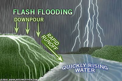
Plains to Midwest: Repeating Thunderstorms Could Cause Flooding
AccuWeather
Weather Talk
By Mark Vogan

BERMUDA HIGH DOMINATES
DANGEROUSLY HOT FROM TEXAS TO CAROLINAS TO WASHINGTON DC TODAY!
EXPLAINATION OF THE DANGERS OF THE HEAT AND HUMIDITY COMBO IN THE SOUTH,
WHERE ARE THE MOST HUMID LOCALES?
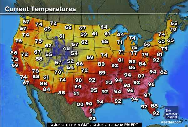
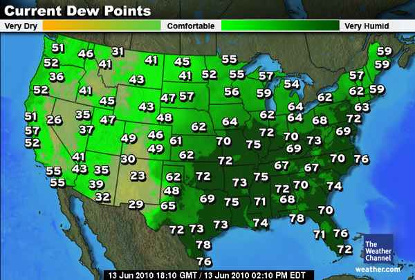
As you can see from these three graphics courtesy of The Weather Channel, both temperature and dew point are very high and thus creating a dangerous situation for the South and East today! Though June 12th is typically pretty hot for the American South or “Sun Belt” as it’s also known as, the Bermuda high which typically controls the weather in this part of the world, it has not only anchored a cell or core directly over south Georgia/north Florida and forcing maximized “sinking” of air which is ultimately producing the intense heating on the ground but it’s stronger than normal. Explaining why it’s become so hot. As well as it’s strength it’s position is drawing very humid air north and northeast from the Caribbean Sea and Gulf of Mexico. These waters are as warm as 80-85 degree at the surface and this tends to moisten the lowest levels of the atmosphere over these tropical water bodies. By producing a wind flow (winds blow clockwise around a high pressure center) across these bath-tube warm waters and anywhere that’s in the path becomes super saturated. The nasty but classic Sun Belt combo of high tropical humidity and blowtorch heat makes for a deadly situation, this occurs each and every summer in this very region, this happens to be the first occurance of the deadly twosome. The abundant foliage of the South as well as the countless swamps, inlets and bays of the Gulf Coastline and around Florida, also aids in increasing the humidity particularly around coastal areas, so don’t be surprised if whilst your visiting the beaches of the Gulf and south Atlantic coasts, it feels unbearably sticky and hotter than you’d realise. The LOW 80 degree dew points regularly achieved along the Louisiana coast and even inland (when considering the swamps and Lake Ponchatrain), the Florida Panhandle, Tampa Bay and up the eastern Seaboard from Miami-Ft Lauderdale to the Outer Banks to Chesapeake Bay that those waters heat even more than the ocean (smaller bodies of water in subtropical summertime climates see waters perhaps 2-5 degrees warmer than larger water bodies, perhaps warming to between 88-93 degrees, whilst open Atlantic and Gulf waters may warm to only 85-90. This further warming to produce HIGHER HUMIDITY and this can often by a danger not aware of by tourists that think it will be cooler because their next to the ocean or lake. Many times during heat waves in the East, take note at how dew points can go as high as 85 degrees in what I’ve come to note as key heat, humidity danger zones, which are the Texas coast from Corpus to Galveston, the Louisiana coast, the stretch from Mobile to Panama City and finally the eastern Carolinas as well as eastern Virginia coast up to Chesapeake Bay. Heat Indexes can top 120 degrees easily, and I’ve seen SEVERAL times in only the last 5-10 years, where areas have seen heat indexes top 130 degrees, making heat stoke IMMINENT!
These areas also see the highest nighttime readings because of the humidity, not the actual heat… Therefore explaining why areas nearer the coast see temps hold perhaps 2-5 degrees HIGHER than place further inland. You’ll see Miami, New Orleans and other areas near extremely warm water have regular lows around 80 degrees, whilst points only 10-15 miles inland seeing lows around 75 degrees.
Stay safe and stay wise in the heat this summer.
Stay cool and hydrated…
Vagaries of the Weather
India & Sub-Continental Asia Weather
By Rajesh Kapadia
Detailed Mumbai Forecast for next 3 days:
A moderately strong Monsoon current will cover Mumbai region from Monday. An off shore low, embedded in the trough will precipitate rains starting from Monday.
Monday:
Day will be overcast with some drenching showers. Rain/Thunder frequency increasing by night.Good Chance of a Thunderstorm.
High: 31c. Real feel temperature will be 35c.Rain quantum (day and night) around 35-40mms.
Tuesday:
Day will have frequent spells of heavy rains/thunder, with chances of flooding and water logging. A typical monsoon day with gusty winds.
High will be 29c, and real feel temperature around 30c.Rain quantum (day and night) about 90- 100mms.
Wednesday:
Heavy rains will continue with occasional thunder and strong off shore winds. Water logging possible in the pre noon hours. Rain intensity might taper off after night.
Rain quantum during the day about 65mms and 35mms during the night.
Read in Full our Partner’s Blog HERE
What’s Reaching Today’s Blogs?
Arkansas Flood Disaster
A fascinating and tragic evolution
Stu Ostro, The Weather Channel
Do You Have a Science Dad?
Jesse Ferrell, AccuWeather
Today’s US Extremes
Courtesy of AccuWeather
High: 104 degrees at Death Valley, CA
Low: 25 degrees at Sunrise Mountain, AZ
Today’s Extremes here at my house
High: 63 degrees
Low: 52 degrees
(Very unsettled with a wet, dreary morning, a brief afternoon clearing with sunshine and then heavy rains took charge for the mid to late afternoon)
Thanks for reading.
-Mark


")


Recent Comments