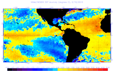
Image courtesy of NOAA
The kind of winter we have just seen with colder than normal from the US to Britain, this kept the jet further south and so too did the warm air. The Sub-Tropical High has been supressed south and kept in a region where the sun is stronger than where it normally would in winter, the Med and North Africa. So much colder air pushed by warm High’s over the Arctic has pushed the band of cold down and below that the sub-tropical high where, within a warmer overall environment, waters below can heat, in fact, WELL ABOVE NORMAL WATERS STRETCH UNINTERUPTEDLY FROM THE WEST AFRICA COAST AND THE CAPE VERDE ISLANDS ALL THE WAY TO THE WINDWARDS WHERE THEY HAVE SEEN DROUGHT CONDITIONS THIS WINTER BECAUSE OF THE SUB-TROPICAL HIGH BEING WHERE IT NORMALLY ISN’T. This all reflects back to what I wrote in yesterdays post, the low solar activity, current stage in global temps, the central Pacific centered El Nino and likely the most important factor VOLCANIC ACTIVITY brought brought dominant blocking over the Arctic, which lead to COLD over the Mid-Latitudes (eastern US to Britain to Poland, all the way to Beijing) and thus pushed the warmer air down and over the tropical Atlantic!
This ties in to the theory I had of last summers all-time warm 103 degrees in Seattle. If it was’nt for the cold across much of the US which squeezed the warm air which would normally be covering practically all of the USA was confined to the Pacific Northwest presented all-time warmth whilst record July cold was seeing seen east of the Rockies. Hot air will heat further when squeezed into a tighter space across the Atmosphere and therefore the warm surge was shoved north from the Desert Southwest to Alaska where Fairbanks topped 92 degrees. This was thanks to sub-Arctic air driven south from Manitoba to Minnesota!
The continued warming of the Tropical ocean will bring high octane fuel for tropical cyclones this season, to me, this is similar pre-season conditions to 2005!!
Lower pressures in the tropics and higher pressures further north, should allow a favorable atmospheric as well as oceanic environment to harness tropical cyclone potential which points me towards the belief that this could be a very busy and devastating year which unfortunately means nowhere within the hurricane zone whether it be, the Windwards, Caribbean or Gulf,/East Coasts of the US should rest easy but be prepared and be ready.
Thanks for reading.
-Mark


Recent Comments