March can be the most exciting, dramatic and extreme of all months
From extreme heat to extreme cold, from severe thunderstorms and tornadoes to blinding whiteouts and sub-zero windchills.
March is the major transition from winter to spring and into summer. The big climb out of winter where we visibly as well as visually see the change of season as growth returns. But with summer knocking on the door by this time of year, old man winter doesn’t hand in the towl to expanding heat from the equator all that easily. The Mid-Latitudes is generally the atmospheric fight zone between warmth trying to get to the pole and cold trying to get to the equator, both air sources loose their fight as they loose and gain solar intensity through angle on the horizon bepending upon distance from pole and equator.
WHY THE OFTEN VOLATILE AND VIOLENT FIGHT DURING MARCH IN PARTICULAR?
Ingredients to such wild swings in weather
During the heart of winter, cold air masses often dominate the Mid-Latitudes and so without warmth to any great magnitude, the atmosphere doesn’t have the same energy available.
You need TWO sticks to rub together to light the fire! – MV –
But by March, the sun is high and beating down on earth, building Sub-Tropical High Pressure cells which were weak and retreated down towards the Equator when the winter cold took over last fall. As the Spring sun rises, gains ground as it begins it’s northward journey, so the sub-tropical ridges follow suit and pressurizes the cold to retreat, gaining ground ever so slowly as the cold air masses shrink as warmth begins to take over the Mid-Latitude atmosphere.
These warm ridges migrate north and collide with cold Polar Highs that still want to rule as the atmosphere takes time to warm, that process happens by once a dominant ocean of cold which could not be penetrated, then as spring kicks in, the pole begins to recieve daylight and incoming solar energy which shrinks snow and ice cover, once you shrink the snow and ice in the Arctic which was once dark and frigid for several months, you start to weaken your Arctic/Polar Highs.
The equatorial air starts to heat further and push more against the retreating cold, cracks begin to appear and soon those shorter wavelengths give way to warm air.
The Arctic Oscillation is known to me as the great distributor of Arctic Cold, a positive oscilation will hold and bottle Arctic air over it’s source region (the pole) and thus allowing milder, oceanic air to flow at higher latitudes, often across the USA and Britain, but when the AO switches to negative, the great distributor unleases the Arctic to the mid-latitudes of the US and UK… The North Atlantic Oscillation when negative also will allow the really cold air deep into the eastern US and UK as well as western Europe… This was indeed the case this winter and the persistency in that pattern as well as the shear vast amount of cold air available, brought one of the worst winters to Scotland in 100 years, worst for 30 years for the rest of the UK and for the US, the worst in 25 years with the snowiest ever for many eastern locations…
Intense pools of cold often become apparent when they break off from the mother pool that was a vast ocean over the Northern World a month or two previous, This shrinking and breaking down of cold into smaller pools can lead to volatile weather as often the USA is in the front row of wild extremes as the warmth pushes north and the cold continues to bleed out of the Canadian north.
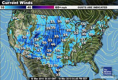
We are currently seeing a first hand presentation of March’s wild swings as a deepening trough drives into the Western US, denting the High that baked LA to 88 degrees and 92 degrees at Santa Ana. The warmth which covered practically all of the US is now seeing pressure put on the atmosphere and as the trough drives south, flipping eastern Colorado’s sunshine and 70s to snow and 20s within a day, what was mild east of the low and trough and where high pressure dominated, that surge of warm air driven by southwest winds will EXCELLERATE as the TROUGH DEEPENS, ultimately colder air drives into the bowl that is the trough and High pressures AHEAD of the frontal boundary (seperation between warm and cold) will push even warmer air into the eastern third of the nation and yesterday 69 in New York will be 75 or greater today with the heat pump being driven by the trough as it drills into Texas. It’s like a push pull of cold and warm.
Often whilst we see wild temperature swings as of course this entire system of low pressure and trough and ridge further east progresses east and driven by the upper flow pattern, the things we see is 70s, 80s one day and then the front pushes through and often a rapid temperature drop will occur and often the following day we might see below freezing and snow falling. That is the case now and was seen dramatically across Colorado between yesterday and early this morning.
Not only do we see wild temperature swings but severe thunderstorm blow up ahead of the main system and therefore major instability occurs as the warmth ahead of the front energizes the core energy within the low pressure center. The frontal boundary within the warm sector however can be the danger zone which can spin thunderstorm that are firing up as the cold air hits against the warmth and moist air and tornadic thunderstorms often occurs. Large hail, dangerous lightening, torrential downpours and damaging winds often result, after these damaging embedded cells push east, often temperatures continue to drop to a point where precip if any is available will turn to snow and once that pushes out, biting windchills can be next on the list.
March Extremes: 2010
Highlights of the Wild Weather
– As of this writing it’s 31 degrees in Minneapolis, MN while it’s 64 degrees in Chicago, IL
– It’s currently 67 degrees in Detroit, whilst Marquette is 30 degrees.
– In Kansas the southeast corner is around 70 degrees whilst the northwest corner is 28 degrees.
– It’s 35 degrees and windy with a windchill of 23 degrees with snow expected whilst it’s 77 degrees at Midland, TX.
– Billings, Montana on Wednesday reported a high of 73 degrees. This morning their low was 19 degrees.
– Cut Bank, Montana on Tuesday reported a high of 67 degrees. Their low this morning was 10 degrees.
– Minneapolis, Minnesota yesterday reported a high of 64 degrees. Their low is currently 31 degrees with snow falling.
Tomorrow I shall post more interesting contrasts and also shall compare March 2010 with 2009 which produced the greatest contrasts I’ve ever seen for March…. Stay tuned.
Thanks for reading.
-Mark


Recent Comments