The days of showing you snow charts are very much numbered. While more snow is expected in the Northeast this weekend, I believe next week heralds the shift that finally takes winter north until Fall.
Because of a system crossing the GL next 2 days, we’re going to see snow through parts of the Midwest into the interior Northeast.
Next 48 hrs.

Credit: AccuWeather Pro (Inc) 2015
[s2If current_user_can(access_s2member_level1)]
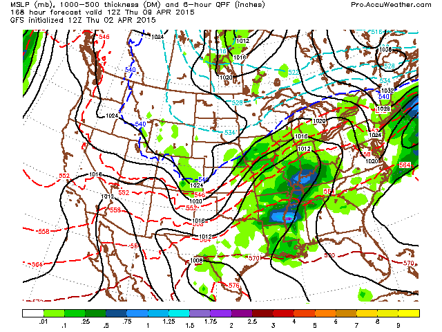
Then a bigger system comes out the Pacific and brings more snow to the N Tier and particularly the central Rockies. Look out Denver and Cheyenne with this one.

Credit: AccuWeather Pro (Inc) 2015
That system will ride a fairly strong southern jet and look for a sharp thermal gradient and severe weather potential as well as flooding rains and backside snows.
The pattern is ready to reshape and reshape so that California finally gets in on some vital precipitation before the dry season takes over. By April, this becomes a crucial time for moisture but when there’s a negative height field dropping out of Alaska and down the West Coast, with very warm water offshore, look out!
Check out the GFS 5-day mean 500mb height anomalies through the next 15 days. This is something we’ve not seen much of in the last 6-12 months.

Credit: AccuWeather Pro (Inc) 2015

Credit: AccuWeather Pro (Inc) 2015

Credit: AccuWeather Pro (Inc) 2015
Notice the negatives draped right across the Southern Tier, this shows the ramp up of the southern branch, fuelled by the warm water against the CA coast.
This is not just a wet pattern down the West Coast including as far south as LA but it’s a major wet pattern further east as the 10-day QPF shows.

Credit: AccuWeather Pro (Inc) 2015
While stronger El Nino’s tend to be good for rain across central and southern California, the drought and time of year means hotter and drier is likely May through August as stated in my summer forecast but comes fall and the seasonal shift kicks in, so I expect wetter conditions in association with the ENSO to kick in.
As for the GFS surface, here’s a look at the upcoming weekend system which could bring a White Easter to some in the interior NE. Severe weather for some in the Southeast.

Credit: AccuWeather Pro (Inc) 2015

Credit: AccuWeather Pro (Inc) 2015
Here comes next week’s cross country system.

Credit: AccuWeather Pro (Inc) 2015

Credit: AccuWeather Pro (Inc) 2015

Credit: AccuWeather Pro (Inc) 2015
Credit: AccuWeather Pro (Inc) 2015
SPC does show slight or enhanced risk for severe weather with this late weekend into the weekend storm system.
Day 1

Day 2

More tomorrow. Be sure to watch today’s video which discusses yesterday’s summer forecast.
[/s2If][s2If current_user_cannot(access_s2member_level1)][magicactionbox id=”18716″][/s2If]


")


Recent Comments