
The latest GFS ensemble supports both a positive NAO along with building heights from the Azores up over the UK, Low Countries and even Scandinavia.

The models will shift a little west and east as to exactly where the ridge core will be positioned next week. A lot will depend upon how strong and how far east any Atlantic trough is positioned.
GFS 500mb height anomaly for this Saturday.

Next Friday.

[s2If current_user_can(access_s2member_level1)]
Here’s the latest GFS sea level pressure charts from the low this weekend to the soaring pressures of mid and late next week.
Watch as the Azores high migrates northeastward with the core appearing to stay east of the UK, more on the Belgium and Dutch side of the North Sea, different to yesterday but like I say, the models will fluctuate with exact positioning. Even with a further east ridge, this setup would have the boundary separating high from low a touch close to the UK’s western door but would still support a warm SSW air flow.
60 hrs

Courtesy/Owned by AccuWeather Pro
120 hrs

Courtesy/Owned by AccuWeather Pro
144 hrs

Courtesy/Owned by AccuWeather Pro
168 hrs

Courtesy/Owned by AccuWeather Pro
204 hrs

Courtesy/Owned by AccuWeather Pro
Notice the boundary hanging over Ireland and Scotland at 168 hrs. It’s far too far out to make a forecast on this but the overall idea is that we’re going to see a substantial ridge building northward over Western Europe mid to late next week after a wet, windy and cool weekend coming up.

Courtesy/Owned by AccuWeather Pro
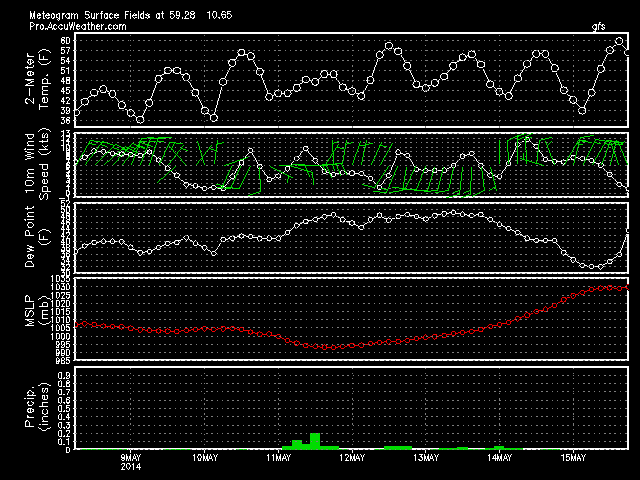
GFS Meteogram through the next 8 days…
DUBLIN

AMSTERDAM

OSLO
Next Europe video will be available once again tomorrow morning at 9.15am.
[/s2If][s2If current_user_cannot(access_s2member_level1)][magicactionbox id=”18716″][/s2If]


")


Recent Comments