>
Join The Conversation!
In Today’s Blog
SEE BELOW: Another Week Of Above Normal Temps Ahead For UK & W. Europe
SEE BELOW: HEAVY SNOW TP SPREAD FROM E MONT TO UP MICHIGAN TODAY, SPRING-LIKE STORM TO IMPACT LARGE AREA OF US BY MIDWEEK
(INCLUDES VIDEO BY MARK VOGAN)
I am currently in the process of producing a video which includes the best winter photos by my Facebook fans. If you have any winter photo’s, be sure to upload them to the Facebook page and they will be included in the video along with your name and your town/country. Should be ready for release by late March/early April 2012
Today’s Global Weather Headlines
Europe Latest
Another Week Of Above Normal Temps Ahead For UK & W. Europe
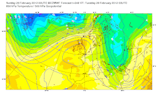
The stubborn Azores high will continue to keep away any true active weather this upcoming week with glimpses of unsettled weather crossing Scotland. It will be a generally wet and blustery day across Scotland tomorrow but by Tuesday, Scotland joins the rest of the UK in more settled conditions. If your anywhere from the Midlands southwards, you’ll know well how little proper rain you’ve had and as well as that, the sunshine is favouring you. Those heights are too strong across central and southern UK and thus skies have lighter winds, somewhat brighter skies and milder air.
This weekend saw a brief flattening of the high and this allowed more cloud and a slight reduction in temps, however, the south and east still saw plenty of sunshine and temps up to between 10-13C, that’s still above normal while the northern UK, while it’s somewhat cloudier, a good deal wetter and at times, windy, it is still around normal or even abopve normal temperaturewise. It’s the persistency in the high which is keeping any sort of cooler air away and therefore I am beginning to think that this February may end up one of the warmest.
Certainly this upcoming week will help boost the monthly deficite as the high builds back into the UK and temps are likely to widely reach between 12-16C throughout much of the UK, including Scotland. I continue to believe that Wednesday may take a run at the 19.7C February record as the centre of the high shifts to the southeast of London which would help bring in those warming southwesterlies. The surface and upper charts support that and combined with strong heights (by Feb standards), combined with the effect of downslope warming and the much drier than normal soils, this is a real possibility, like anything however, this may change.
The rest of the week remains fairly settled with the high shifting slightly further east. The majority of the western continent looks to have a glorious mid to late week with good, widespread sunshine and mild temps. The clear skies and light winds at night may allow for frosts but certainly, from the UK to east Germany, Wednesday onwards is looking terrific.
Current charts off ECMWF
US Latest
New Severe Weather Threat Coming Up Monday Night
An area of low pushing through the upper Midwest today will bring a swath of heavy snow from eastern Montana to the UP of Michigan while a secondary low behind it will bring much more widespread weather impact across the Lower 48 as we head into the midweek!
A write-up and video will be available shortly, stay tuned!
Updated Severe Weather Analysis for Tuesday and Wednesday, 2/28 and 2/29–INNOVATION WEATHER–David Saurer
INNOVATION WEATHER
Snow and Severe: Spring Ahead
THE WEATHER CHANNEL
Early Week Severe Storms to Take Aim on Mississippi Valley
ACCUWEATHER.COM
Winter Returns To West
Chilly Storm Aiming for Southwest
ACCUWEATHER.COM
& Northern Plains
Australia Latest
Hard Hit Areas of South Queensland Finally See Respite For The Big Storms, Turning Stormier, Wetter Across South Australia
THE EXTREMES OF THE DAY
TODAY’S US EXTREMES
COURTESY OF ACCUWEATHER
HIGH: 84° at Gila Bend, AZ
LOW: -14° at Daniel, WY
TODAY’S UK EXTREMES
COURTESY OF THE MET OFFICE
HIGH: 58° (14.5°C) at Fyvie Castle (Aberdeenshire)
LOW: 28° (-2.1°C) at Benson (Oxfordshire)
TODAY’S EXTREMES HERE AT MY HOUSE
HIGH: 47°
LOW: 44°
Thanks for reading.
-Mark


Recent Comments