>
Stay With Weather & Climate Through the Eyes of Mark Vogan This Tropical Season For Trusted Forecasts, Advice & Important, Vital Updates To Guide You Through the Rest of this Season!
In Today’s Blog
#BRITISH ISLES-EUROPE
Large Temperature Contrast Across UK Today
#INDIA-SUB-CONT
Latest Weather from India & Sub-Continent By Rajesh Kapadia
Today’s Weather Headlines
Tropical Storm Lee Set to Dump Upwards of TWO FEET of Rain on South-Central, Southeast Louisiana Over Next 5-Days
SEE #WEATHER TALK (CLICK HERE) FOR DETAILS ON TROPICAL STORM LEE AND IT’S PROJECTED IMPACTS ON LOUISIANA….
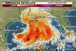
Mark Vogan: My Explaination for why Lee Could Become a Cat 1 or 2 Hurricane quickly before reaching Louisiana!
Models continue to suggest a relaxing of the wind shear over the northern Gulf of Mexico and if that happens, I strongly believe that Lee will have enough time over those abnormally warm waters to become a Cat 1 or 2 Hurricane. You can see from the above image that the system is lopsided and dissorganised, however, notice the large canopy of convection on ALL sides except the side exposed to shear, all the ingredients are there with extremely warm water beneath and a structure which only needs to see less windshear to stack vertically and we would very quickly see the convective wrap completely around the center. By drawing all the available energy surrounding this system, you would quickly see intensification of Lee and this would really get going.
With a light steering flow, this growth into a hurricane is also made much more possible. With a forward movement of say 10+ mph and only 185mph from shore, I would question whether this had time, but since the steering flow is so light, all it takes for this system to not only be a major rainmaker but possibly a much greater problem for the central Gulf Coast would be if the shear eases and all of a sudden wind, wave and surge is just as much an issue as the flooding rains. Especially if it’s as slow as it is. Think about it, having a painfully slow rainmaker is one thing but having a hurricane of even only 75 mph that is battering the coast for over a day, even more damage is highly likely.
Local Information
New Orleans levees get a near-failing grade in new corps rating system
NOLA
Tropical Storm Warning includes N.O. area
WWLTV
Latest From the NetworksTropical Storm Warning Issued on Gulf Coast as Louisiana Declares State of Emergency
FOX NEWS
Gulf braces for wallop from drenching rains
CBS NEWS
20 inches of rain? Flood warnings for US Gulf coast
NBC NEWS
In Other News Today
Earthquake Strikes Along Alaska’s Aleutian Islands Chain
6.8 Quake Prompts Brief Alaska Tsunami Warning
ABC NEWS
Quake strikes off Alaskan coast
CNN
Massive Waves To Pummel Southland Beaches Through Sunday
CBS LOS ANGELES
Nigeria floods: Death toll in Ibadan rises
BBC WEATHER
THE EXTREMES OF THE DAY
TODAY’S US EXTREMES
COURTESY OF ACCUWEATHER
HIGH: 113° at Bullhead City, AZ
LOW: 24° at Stanley, ID
TODAY’S UK EXTREMES
COURTESY OF THE MET OFFICE
HIGH: 80° (27°C) at Heathrow (Greater London)
LOW: 44° (6.8°C) at South Newington (Oxfordshire)
TODAY’S EXTREMES HERE AT MY HOUSE
HIGH: 60°
LOW: 54°
Thanks for reading.
-Mark


Recent Comments