>FOLLOW THE BLOG ON FACEBOOK & TWITTER AND CLICK LIKE/FOLLOW FOR REGULAR LOCAL, NATIONAL AND INTERNATIONAL WEATHER UPDATES, LINKS & MORE!
TODAY’S TOP WEATHER STORIES
On Weather & Climate Through the Eyes of Mark Vogan
Thousands Pack Up Along Mississippi Ahead of Possible Spillway Opening
FOX NEWS
Jindal: Decision on opening spillway could come Saturday
CNN
The Importance of the Morganza Spillway
THE WEATHER CHANNEL
One “Exceptional” Drought
THE WEATHER CHANNEL
TODAY’S WEATHER ACROSS AMERICA By Mark Vogan
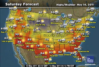
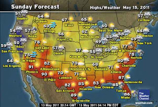
Your Weekend Forecast
An offshore low pressure system off the Northeast coast has put the breaks on the overall west to east flow across the country and with a storm over North Amrica, this has slowed way down, making for a longer period of time with rains and thunderstorms. The system is creeping eastwards and with a buckling of the jet across the continent, we’re seeing the rebuilding of a ridge up the West Coast, the associated trough in the central Plains that’s associated with the storm system and along a boundary between the leading edge of this trough and rail track for low pressures to ride, we have heavy and persistent rains falling in the already saturated flooded areas of the mid and lower Mississippi valley. Further east, though there will be plenty of rains throughout the weekend stretching from the flood zone to East Coast, we do have ridging between the Plains trough and low offshore, thus it will be warm.
TODAY’S WEATHER ACROSS UK & EUROPE By Mark Vogan
Trough remains firmly entrenched across UK, central, southern Europe that’s currently fine, dry and warm to see change to more unsettled weather!
As the low now spins north of Scotland, though we’re seeing much of the same type of weather conditions of sunshine in between showers, winds are changing from the mild southwesterly direction to a chillier northwesterly direction, thus trimming 14 to 16C highs down to 12-14C across Scotland for Saturday and Sunday. Slightly higher thickness values or stronger pressures further south and away from the low pressure effects across southern England mean slightly warmer tenperatures despite still cloudy skies and rain showers. We’re looking at 15 to 18C highs here across the south.
As for Spain, well, despite some thunderstorm activity across the NE of the country, skies have been mostly sunny with highs ranging from the low 30s C in the south, mid to upper 20s in the central region to mid-20s across the north and up through the majority of France. Low 20s C for northern France including Paris. Across the Med, temperatures have been warm under plenty of sunshine and highs in the mid to upper 20s C in such cities as Rome and Athens.
A trough over the eastern Med has kept temps more at bay for Turkey, Cyprus and other surrounding areas.
As for the coming 48 hours. The UK will see the low trek off towards Iceland and winds turn more westerly by Sunday and Mponday thus keeping us mild with 15C for the north, 18C for the south with rain showers likely anywhere. For Spain it remains pleasant and sunny with similar temps to what we’re seeing right now and for southern Europe stretching from southern France across through Italy, Greece and towards Turkey, a low will swing trhough providing more unsettled weather and a trim of a degree or two of current readings with a rainfall, likely in ‘shower’ fashion.
The precipitation area may provide snowfall to the higher reaches of the Alps.
WEATHER TALK
By Mark Vogan
England’s recent thunderstorm bearing skies caught on camera
Caused by a warm, moist surface flow straight from the Mediterannean Sea and supporting temps of 22C or higher, a hot/dry mid layer and a cold upper layer that contained temps of -60C or lower
VAGARIES OF THE WEATHER
INDIA & SUB-CONTINENTAL ASIA WEATHER
BY RAJESH KAPADIA
Posted on 8th May;
Detailed Note sent by Neeraj from Nepal:
We in Nepal think of arrival and departure of monsoon in terms of Nepali calender dates. Generally Asar, Shaun and Bhadau are three monsoon months which translates to June 15 to September 15.The farming community fix the dates for sowing and harvesting according to Nepali calender, so 15 Asar is the day they plant rice (esp in the mountains, in the plains there can be more than one harvest of rice). 15 Asar generally falls on July 1st. It is assumed that by this time enough rain has fallen to make the rice fields muddy enough for the planting.
Monsoon enters the country from the east and progresses towards the west. The amount of rain is generally more in the east than the west. And monsoon lingers for more amount of time in the east.
Geographically Nepal can be broadly divided into three regions progressing from the north to the south. The northernmost region is the high Himalaya. The snow line is at 5000 m. So all the peaks above this would be snow capped throughout the year.As far as I know (heard somewhere), the higher peaks are not affected by the monsoon system that much as the monsoonal flow is below them. In the valleys and lower slopes, there is human habitation, and south facing slopes get ample amount of the rains. The same is not true for the north facing slopes. Places to the north of the main peaks of himalaya are in rain shadow, one example is Jomsom whose average annual rainfall is only 250 mms.
The middle part is what we call the mid-mountains or mid-hills. This is the place where most of the people live. And this places get good rain in the monsoon. As far as travelling in monsoon goes, westerners generally do not travel during the monsoon season. Whenever there is a heavy downpour, we get a lot of landslides and roads could be closed for days. And all the rivers are swollen to their fullest during monsoon and in places where there are no bridges, the crossing gets very tricky. And yes, you don’t get to see the view of the Himalayan peaks most of the time as they are covered. Some airports (mostly grass field ones) don’t operate during the monsoon.But south asian tourists are not as put off by monsoon as much as the westerners.Many Indians do visit during this time as the climate is considerably cooler in the cities like Kathmandu and Pokhara compared to the Indian cities during the monsoon.
The southernmost part is the TeraVerdana, sans-serif;”>On”Madhes” is preferred in the place of “Terai”). Madhes stretches from the east to the west. In the east it boarders West Bengal in India and in the west its Utteranchal. The easternmost town is Kakadvitta whose climate is similar to Siliguri in India. And the westermost town is Mahendranagar whose climate would be similar to maybe Dehradun. Madhes is thin strip of land , at places only 10 Kilometers wide. At others around 25 Kms. And of course, it rains more in the east than the west. It true for all three regions. The climate in Madhes is hot to very hot. Cities like Bhairahawa, Nepalgunj and Dhangadi sometimes see temperature climb above 40 degrees mark. During 2008-2009 I was in Bhairahawa and have experienced upto 42 degrees there. That’s the highest I have ever endured (i think!).
As far as the kind of rainfall goes, its generally thunderstorms/hailstorms and thundershowers during this time of the year (April-May) and also somewhat during the end of the monsoon. But during the monsoon itself, its more prolonged kind of rain. Its generally not a heavy shower but rather light to moderate drizzle. And it rains on and off for days. Sometimes there is a break of few days, sometimes there is no noticable break.It is generally assumed that it would rain everyday at least during Asar and Shaun months.There are hazards associated with the rains too. I forgot the exact year but it was either 1994 or 1993 monsoon season when there was a massive cloudburst just west of Kathmandu. The main access road to Kathmandu was washed away in many places and almost all the bridges in that road were gone.
But a lot of things depend on Monsoon over here. I think its the same for all of south asia. One thing we lack these days is electricity. As the demand has gone up exponentially, the supply is short and we get many hours of daily power cuts. And during the monsoon, the situation is much better as all the hydro electric stations are generating at full capacity.
Check out our partner’s blog now, by clicking here for the very best India and Sub-Continental Weather.
WHAT’S REACHING TODAY’S BLOGS?
Chilly Week Ahead
Joe Lundburg, AccuWeather
Today’s Severe Weather Outlook, Plus a Look at Next Week!
Henry Margusity, AccuWeather
THE EXTREMES OF THE DAY
TODAY’S US EXTREMES
COURTESY OF ACCUWEATHER
HIGH: 103 degrees at East Mesa, AZ
LOW: 21 degrees at Angel Fire, NM
TODAY’S EXTREMES HERE AT MY HOUSE
HIGH: 57 degrees
LOW: 45 degrees
Thanks for reading.
-Mark


Recent Comments