>FOLLOW THE BLOG ON FACEBOOK & TWITTER
TODAY’S TOP WEATHER STORIES
On Weather & Climate Through the Eyes of Mark Vogan
LIVE NEWS FEED…
-Bartlesville, OK despite snow still on the ground has warmed to 70 degrees, up from the frigid 28 below zero reading from just 6 days ago… That’s a remarkable jump of 98 degrees.. Ponca City, also has snow on the ground and this is evident. Despite a toasty 64-degree reading, it’s evident over northern Oklahoma the presense of snowcover, especially when southwest Oklahoma has topped 80 degrees.
-Valentine, NE has reached 70 degrees
-Garden City, KS has reached 80 degrees
-Guymon, OK has reached 82 degrees
-Guymon, OK has reached 80 degrees.
-It’s currently 65 below zero (-54C) with flurries at Oymyakon, Siberia
Oklahoma is up 113 degrees from 6 days ago as Guymon reaches 82 degrees
VERY WARM WEATHER SURGES INTO TEXAS AND UP THROUGH THE PLAINS TODAY, 80S, NEAR 90 FOR TEXAS, 75-80 for OKLAHOMA, 70S ALL THE WAY TO KANSAS AND PERHAPS NEBRASKA
CHECK OUT THESE NUMBERS ALREADY!!
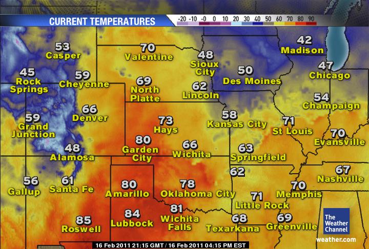


After yesterday’s amazing 74-degree high in Oklahoma City and today possibly reaching 75 or 76 degrees there, if anywhere in Oklahoma tops 80 degrees today, this would be an incredible 111-degree rise in only 6-days from Nowata’s record-breaking 31 below zero. I strongly believe somewhere in the state will reach 80 degrees whilst west-central Texas could climb close to 90 degrees, yes and this region too saw near zero just six days ago. Note Amarillo’s expected high of 80, perhaps 81 degrees, just 6 days ago the low plunged to 6 below zero and the morning before, a raging blizzard was in progress with 35-45mph winds blowing in 0 to -2 degree air which creating very extreme windchills in and around 40 below zero… Yes just a week ago!.
February Spring Fever!
THE WEATHER CHANNEL
Carlos and Now A New Australia Cyclone Threat
ACCUWEATHER NEWS
TODAY’S WEATHER ACROSS THE UK & EUROPE
By Mark Vogan
Benign Pattern Continues for NW Europe with Atlantic Lows Keeping UK unsettled
With a persistent and active Atlantic jet flowing across the NW of Europe, including Britain, the weather remains unsettled. Parts of England and Wales see off and on showery spells whilst Scotland enjoys a little sunshine and then it only takes till the following afternoon and it’s the reverse. As these lows spin eastwards however, enough chilly air from the north gets dragged in from western Scandinvia where it’s moderately cold and here, we’re seeing rain turn to sleet and snow for a time, so I will say that despite us being in an overall mild pattern, it’s pretty typical for this time of year and we are seeing chilly weather and snow off and on that’s making this pattern not quite as mild as it otherwise could be. It’s certainly nothing to write home about in terms of snow or cold however. Even when there’s a wind blowing out of the southeast and the air is 2 or 3C, creating a windchill, keep in mind that there’s still no Arctic air or really any ‘cold’ air around. All this is no focusing on far east Europe.
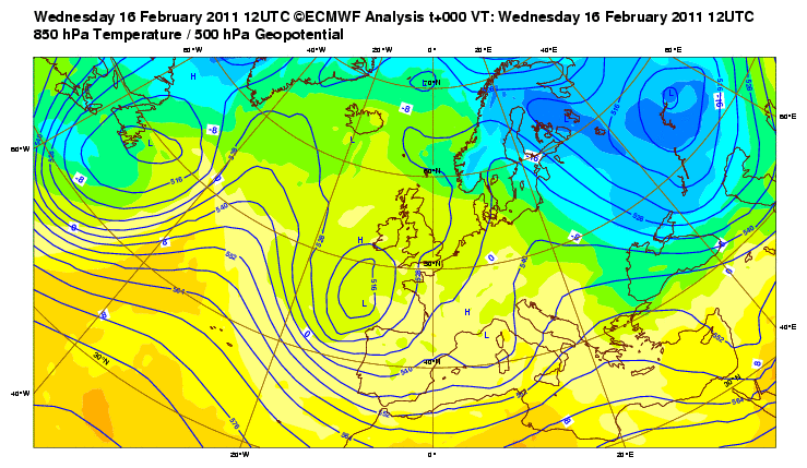
Moscow to ‘warm’ to only -22C tomorrow!
The really cold air stationed over far eastern Europe, stretching from Finland, The Baltic States, across the Russian Heartland and down into the Ukraine is taking real charge now as this ai grows increasingly colder through this week. Daytime high’s are struggling to reach -15C or low to mid 0s F in both Helsinki and Moscow and it appears the Arctic air will grow colder as fresh impulses of Arctic air flow southwards across this landlocked region. Tonight will see Moscow dip towards -25C (-13 F) and tomorrow, there will be literally no recovery despite sunshine. The high is only expected to reach a bitter -22C/-8F according to the BBC, easily the coldest day of winter so far. For Helsinki the low tonight is expected to dip to around -18C or 0F and warm to -15C/5F tomorrow. See Weather Talk below for details on the coming days which look coldest of all!
TODAY’S WEATHER ACROSS AMERICA
From AccuWeather

Watching For a Midwest, Northeast Storm Next Week
By Alex Sosnowski, Expert Senior Meteorologist
Wild Spring Ahead With Late-Season Snow, Tornadoes
By Heather Buchman, Meteorologist
Good Weather At Daytona For First Time in 3 Years
By Gina Cherundolo, AccuWeather.com Staff Writer
Pacific Storm Unleashing It’s Fury On Southwest
By Kristina Pydynowski, Senior Meteorologist
WEATHER TALK
By Mark Vogan
WORST OF COLD TO COME THURSDAY THROUGH SATURDAY FOR MOSCOW, HELSINKI AND SURROUNDINGS
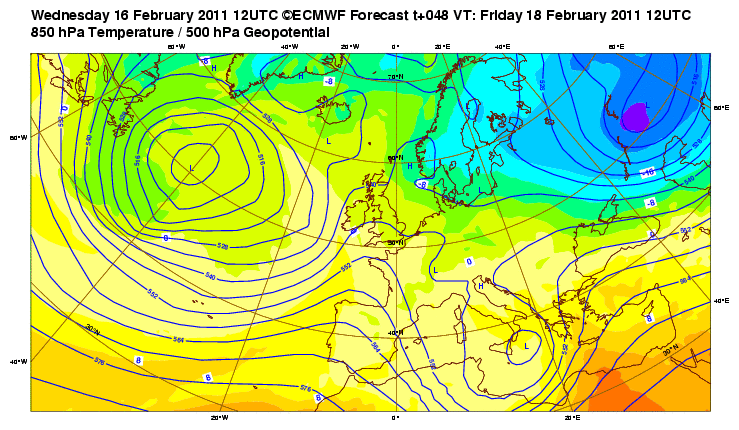
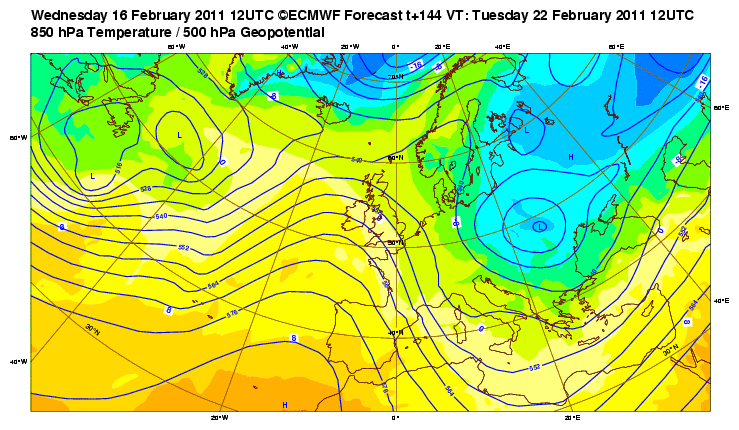
Though the cold doesn’t appear to be set to leave the eastern Europe, western Russia region anytime soon, the core of core however looks set to drill a region from Helsinki to Moscow down to Kiev over the next 48 to 72 hour period. As for can see from the map below which is the European for today, Thursday and next Tuesday that the ‘purple bullet’ which shows intense Arctic cold making it’s nearest apprah to these far eastern European cities.
It’s likely that tomorrow after a frigid night tonight will remain under -18C in Moscow, under -15C in Helsinki and even under -10C in Kiev. Tomorrow night and into Friday may be the coldest 24 hour periof with Moscow enduring a high of perhaps only -23C and a low which dives towards -27C or even neaer -30C whilst Helsinki struggles to reach -20C Friday and dives towards -30C one, perhaps two nights.
It would appear that the core of cold always remains slightly east of this region all in all and further away from the bodies of water such as the Baltic and Black Seas, although their hardly warm. Whilst central Moscow may be cold, even outlying areas just 10 or so miles away from the central region of the city, it may struggle to reach -25C by day and -35C by night, certainly the region east of Moscow which looks closer to the core, highs may be only around -28/-30C with lows dipping under -40C.
WHAT’S REACHING TODAY’S BLOGS?
A Dry Thaw Followed by a Stormier Period
Joe Lundburg, AccuWeather
Next Storm Packs a Big Punch
Ken Clark, Western Expert, AccuWeather
We May See Winter Make a Return Next Week
Henry Margusity, AccuWeather
THE EXTREMES OF THE DAY
TODAY’S US EXTREMES
COURTESY OF ACCUWEATHER
HIGH: 91 degrees at Pecos, TX
LOW: -17 degrees at Presque Isle, ME
TODAY’S UK EXTREMES
COURTESY OF THE MET OFFICE
HIGH: 53 degrees (11.7C) at St James Park (Central London)
LOW: 28 degrees (-2.2C) at Shobdon (Herefordshire)
TODAY’S EXTREMES HERE AT MY HOUSE
HIGH: 44 degrees
LOW: 38 degrees
Thanks for reading.
-Mark


")


Recent Comments