>FOLLOW THE BLOG ON FACEBOOK & TWITTER
TODAY’S TOP WEATHER STORIES
On Weather & Climate Through the Eyes of Mark Vogan
BREAKING NEWS: MOSCOW, RUSSIA WILL REACH IT’S COLDEST LEVELS OF FEBRUARY 2011 TONIGHT AND NEAR THE SEASON MINIMUM OF -10F, IT’S ALREADY 0 DEGREES OR -18C AS OF MIDNIGHT. ST PETERSBURG IS CURRENTLY -8F, HELSINKI -6F AND LULEA IN NORTHERN SWEDEN IS AT -20F. THE COLD IS TO GROW STRONGER THROUGH THIS WEEK! See Weather Talk below for readings of -71F in Siberia!
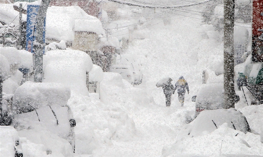
‘Snow bomb’ hits South Korea
MSN.COM
South Korea chaos after ‘heaviest’ snowfall
BBC ASIA-PACIFIC
Another Big Quake Shakes South-Central Chile
ACCUWEATHER NEWS
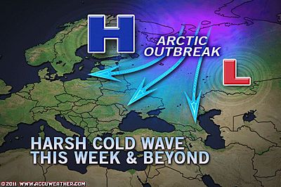
Harsh Cold Wave Gripping Russian Heartland
ACCUWEATHER NEWS
Cyclone Strikes Madagascar
ACCUWEATHER NEWS
TODAY’S WEATHER ACROSS SCOTLAND, UK & EUROPE
By Mark Vogan
Moscow to Shiver In Coldest Air Since January 2006 While UK Flirts with Chilly Air that’s producing low-elevation snow tonight
A deep trough that’s expanding southwards across far east Europe and focusing on St Petersburg down into the Russia Capital of Moscow with -18C or colder air this week, it appears that once the final snowclouds depart the city, home to some 14 million people will face the harshest cold since the fierce cold outbreak of January 2006 when a high of -26C and a low of -30C was achieved.
As for here in the UK, well enough cold air, which I use in a relative sense is filtering in and colliding with Atlantic moisture and this is creating sleet and even snow to low levels across many areas of Scotland this evening and likely into tomorrow morning. The low-elevation snowfall which may bring a coating, particularly to grassy surfaces and vehicles and not so much to pavements which are too warm and wet should push north to more northern areas through the overnight tonight. This makes way for clearer skies for the south and central Lowlands, presenting the region with a chance of frost formation and ice!
This was the hailshower this pushed through Lennoxtown late this afternoon, once that pushed through temperatures dropped to 37 degrees (2C) and rain turned to sleet and finally this evening it then turned to snow which coated the grass and cars.
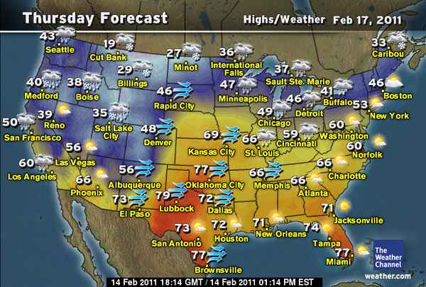
TODAY’S WEATHER ACROSS AMERICA
From AccuWeather
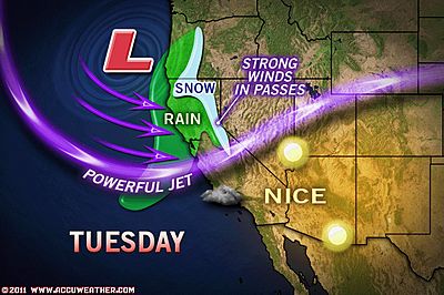
LA, California in for Rounds Of Rain
By Alex Sosnowski, Expert Senior Meteorologist
Heat, Wind Increase Southern Fire Risk
By Gina Cherundolo, AccuWeather.com Staff Writer
Sloppy Times Ahead, Car Washes Rake In Big Bucks
By Alex Sosnowski, Expert Senior Meteorologist
Shifting Ice Always a Concern For Lake Eries Fisherman
By Alex Sosnowski, Expert Senior Meteorologist
WEATHER TALK
By Mark Vogan
ONLY ON THE AMERICAN PLAINS!!!!
LAST WEEK
first this…
then this….
To This…

COLD REALITY
OYMYAKON, SIBERIA ENDURED A 71 BELOW ZERO LOW THIS MORNING

AVERAGE FOR FEB 14TH (F)
HIGH: -41
LOW: -56
It’s amazing to think that people actually live here. They put ALL of us to shame who moan about a little cold. When I say a little cold I mean our 9-day stretch below freezing and 3-degree low which for us here in central Scotland, felt like it was “Siberia”, LOL…
Oymyakon, tucked away in far northeast Siberia, well away from civilisation and within a valley which once freezing air settles in, usually at the start of ‘October’, it doesn’t usually get even close to freezing till perhaps as late as April. So far, since October 6, 2010, it’s not reached freezing. The highest temperature in January 2011 was a balmy -6 (-21C), coldest was a frigid -78F or -61.2C, yes even for here that is pretty cold, especially when it’s the lowest reading since January 2003 when the thermometer reached a slightly lower -61.4C or -79F. The coldest high in January was -67 or -54.8C.
Now, here’s the amazing thing, ok, are you reading for this…. January ended up 9.8F ABOVE NORMAL, so folks here got away with a relatively warm January!
As for December 2010, yep it was 8.3F above normal, another ‘balmy month for the residents of Oymyakon. The warmest reading was +18 or -8C, that was actually extremely mild, especially when the ‘normal high’ is a somewhat chillier -47. The coldest low was a bone-chilling -75 or -59.2C.
As for November 2010, the warmest high was colder than in December suprisingly with a maximum of 4 degrees and the coldest was -64 with the month overall being, yes, you guessed it. +1.7 above normal.
Now to go against the grain and to show how fickle winter here can be, the first 14 days of February 2011 are running 4.4 BELOW NORMAL.
Since the 7th, five days in a row didn’t see a daytime high get above 50 below zero and out of the last 7 nights, six of those have dipped to 66 below zero or colder, two of which hit 70 below zero and this morning it hit 71 below zero.
WHAT’S REACHING TODAY’S BLOGS?
This Winter vs. Last in the Northeast: No Warmth
Jesse Ferrell, AccuWeather
Monday Morning Video on the Winter Battle Setting Up
Henry Margusity, AccuWeather
Roller coaster ride
Valley Weather (Montreal, QC Area)
THE EXTREMES OF THE DAY
TODAY’S US EXTREMES
COURTESY OF ACCUWEATHER
HIGH: 86 degrees at Laredo, TX
LOW: -6 degrees at West Yellowstone, MT
TODAY’S UK EXTREMES
COURTESY OF THE MET OFFICE
HIGH: 52 degrees (11C) at Gravesend (Kent)
COLD HIGH: 38 degrees (3.1C) at Dalwhinnie (Highland)
LOW: 29 degrees (-1.7C) at Cluanie Inn (NW Highland)
TODAY’S EXTREMES HERE AT MY HOUSE
HIGH: 41 degrees
LOW: 34 degrees
TODAY’S CONDITIONS (LOCALLY)
A day which saw mostly cloudy skies and frequent rain showers, some of which were heavy and prolonged. The afternoon saw a breakup of the clouds prior to what appeared to be the arrival of a front as a heavy hailshower pushed through, dropping the temperature into the upper 30s. After this front pushed through hail turned to sleet and by this evening as the temperature settled at around 37, sleet progressively turned to snow and this accummulated on grassy surfaces and cars. Skies have now cleared out and ice has rapidly formed as the temperature has fallen to 32 degrees.
Thanks for reading.
-Mark


")


Recent Comments