>FOLLOW THE BLOG ON FACEBOOK & TWITTER
TODAY’S TOP WEATHER STORIES
On Weather & Climate Through the Eyes of Mark Vogan
BREAKING WEATHER: Breathtaking Temperature Contrast In Texas! The Arctic Air Has Progressed South Throughout Today!
Currently 3 degrees at Amarillo with a realfeel of -32 whilst it’s 82 at Pecos!!!!


THE POLAR EXPRESS RIDES INTO TOWN
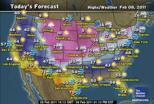
A Cold Start: Glasgow, MT -25, International Falls, MN -20, Minneapolis, MN -9
ARE YOU SICK AND TIRED OF WINTER?
A Fresh Surge of Brutal Arctic Air flows down the Plains Yet Again and collides with a storm moving east out of Rockies along the jet stream and this will produce a Major Snowstorm across Kansas, Oklahoma and far north Texas
-By Mark Vogan


A strong Pacific storm off the North American west coast is pumping warm air all the way up into Alaska and the northwest of Canada and in doing so is forcing brutally cold ‘near late season’ Arctic air down into the heart of the lower continent. a storm system that’s just moved out onto the Southern Plains is meeting this southbound pool of powerful Arctic air and yep, you’ve guessed it! Another MAJOR SNOWSTORM for Kansas and Oklahoma, perhaps 3-6 inches even across far northern Texas but a uniform 6-12, locally 18 inches is likely across Oklahoma and up into Kansas. To the north, it’s all about frigid air with minus teens across North & South Dakota into Minnesota and Wisconsin, even -20s in NE Montana. Tonight after a huge area of the northern and central Plains, all the way down to north Kansas struggles to reach double digits, tonight will see the area of minus teens expand west-east and further south tonight, perhaps getting down to the Nebraska-Kansas line. South of here, it’s heavy snow and clouds that rule the sky so it won’t get too cold but by tomorrow PM as skies clear out after lows dip into the mid to low teens even within the heavy snowstorm tonight into tomorrow by dawn across Wichita and down into Oklahoma City and Wichita Falls, TX, high’s will be lucky to reach 18-20 degrees and with gusty north winds howling, it’s likely to feel more like 0 or colder all day. Come tomorrow night as much of Kansas and Oklahoma will be under a new foot of snow (sound familiar?) skies will clear out completely and temps drop fast in Kansas and central Oklahoma to numbers comparable to last week, that’s 0 to -15 with spots getting to near 20 below to be precise! We may see a low tomorrow evening of 0 or even colder in Oklahoma City which would be the lowest value here in 15 years!


HOW DOES THIS LATEST COLD STAND WITH THIS SEASON SO FAR?
MINNEAPOLIS, MN: 2nd Coldest Night of Season, low to hit around -14 degrees!
A city that has recieved a hard deal from old man winter this year will suffer knife-edge winds across the Metro today despite sunny skies so grab that heavy winter coat and indeed facemask, yes, it’s one of those days, especially nippy when steeping around a downtown building and you get blasted by a 20mph gust in 5-degree air. Today’s high should reach a mere 5 to 7 degrees but factor in a brisk breeze out of the north and it’s likely to feel closer to -20 all day. Tonight should dip away quickly back below zero after sunset as the stars and moon return . A low of -14 is possible despite the relatively late stage in the season with lenghening days and shortening nights but snow remains deep on the ground and Arctic air can still rule the frozen North for another few weeks yet.
CHICAGO, IL: Tonight to hit -8, Coldest of Winter!
Whilst Chicagoans trudge through snowdepths of 21 inches which is their greatest depth since the 1978-79 season and are on the cusp of their snowiest February on record, they look set to shiver tonight with a low down near or even under -8 degrees as a secondary cold front sweeps south from Manitoba through late today and into this evening, drive that frigid air across a deep snowpack like Chicago’s and your talking a bitter start to tomorrow. The lowest so far is -6!
OKLAHOMA CITY, OK: Firstly it’s potentially another 6-12 inches of snow tonight, through Wednesday, then perhaps the Coldest Night of the Season tomorrow night, first 0-degree reading in 15 years is possible!
The meteorologists in and around Oklahoma City have upped the numbers for snow totals from tonight, though tomorrow’s major winter storm system. It’s expected that 6-12 inches may fall even in Metro Oklahoma City by midday Wednesday and locally higher totals of 12-15″ before skies clear out and the Polar Express then rides across that fresh foot of snowcover that will cover Oklahoma as well as the path in which it runs south from Canada. An uninterupted snowcover, lays a perfect reflective blanket in which it helps stop much modification of the air mass as it heads further and further south away from it’s source of origin. This may result in the city’s coldest temperatures of the season and in 15 years if it hits 0 degrees, that would be tomorrow night under clear, moonlit skies and would remarkably beat the 3-5 degree lows of last week. It really has been a brutally cold past two weeks for the Southern Plains!
COMING NEXT WEEK:WE’RE LIKELY TO SEE ONE OF THE GREAT TEMPERATURE FLIPS OF ALL-TIME IN THE EXACT AREAS SUFFERING THE MOST NOW! JOE BASTARDI PREDICTS DALLAS WILL HIT 80, AND 70 IN WASHINGTON DC, STAY TUNED!
TODAY’S WEATHER ACROSS SCOTLAND, UK & EUROPE
By Mark Vogan
BRITAIN LOCKED IN POSITIVE NAO RUT!
A return to a positive NAO (North Atlantic Oscillation) after the strong & persistant negative in November and December means every 1-2 or 2-4 days, a low moves in off the Atlantic bringing southwest winds, mild ocean air and accompanied by hefty, persistent showers and lots and lots of cloud. Hill snow also occurs and when those lows spin off to the east, cooler air feeds in from the north, forcing low-elevation snow which typically melts within hours. In between we see brief sunny spells, lighter winds and cooler temps like we’ve seen today across much of the UK, but there is any cold air around, or should I say, not ARCTIC anyway. It’s a rather boring pattern I would say as we’re nether warm nor cold but kinda in between and this messy pattern will persistent, likely till at least March!
AFTER SEVERAL DAYS OF MODEST COLD FROM OSLO TO MOSCOW, A RETURN TO ARCTIC AIR WILL SEND HIGHS FROM NEAR FREEZING OF RECENT TIMES TO BETWEEN -15 AND -20C, NIGHTS SINK TOWARDS -25C!
TODAY’S WEATHER ACROSS AMERICA
From AccuWeather

Heavy Snow, High Winds to Disrupt Travel Along I-40 Corridor
By Bill Deger, Meteorologist
With Warm-Ups Come Flooding Concerns
By Gina Cherundolo, AccuWeather.com Staff Writer
Major Thaw, Snowmelt On The Way From Plains to East
By Heather Buchman, Meteorologist
WEATHER TALK
By Mark Vogan
COLDEST AIR OF SEASON FOR CHICAGO TONIGHT, OKLAHOMA CITY TOMORROW NIGHT??


WHAT’S REACHING TODAY’S BLOGS?
Lake-Effect Snow MCV on Lake Michigan
Jesse Ferrell, AccuWeather
Another Cyclone Threat for Australia
Jim Andrews, International Expert, AccuWeather
Big Storm Still on the Table This Week
Joe Lundburg, AccuWeather
THE EXTREMES OF THE DAY
TODAY’S US EXTREMES
COURTESY OF ACCUWEATHER
HIGH: 82 degrees at Pecos, TX
LOW: -33 degrees Plevna, MT
TODAY’S UK EXTREMES
COURTESY OF THE MET OFFICE
HIGH: 52 degrees (11.3C) at Gravesend (Kent)
COLD HIGH: 37 degrees (2.9C) at Dalwhinnie (Highland)
LOW: 22 degrees (-5.6C) at Benson (Oxfordshire)
TODAY’S EXTREMES HERE AT MY HOUSE
HIGH: 44 degrees
LOW: 31 degrees
TODAY’S CONDITION’S (LOCALLY)
FROSTY START WHICH GAVE WAY TO A HAZY/SUNNY DAY WHICH FELT PLEASANT FOR FEB 8. TONIGHT TEMPS HAVE FALLEN TO AROUND FREEZING AND WITH STIFFENING SOUTHERLY WINDS AND 32-DEGREE AIR, A LITTLE WINDCHILL IS BEING FELT THIS EVENING.
Thanks for reading.
-Mark


")


Recent Comments