>FOLLOW THE BLOG ON FACEBOOK & TWITTER
SUPER BOWL XLV SPECIAL

TODAY’S TOP WEATHER STORIES
On Weather & Climate Through the Eyes of Mark Vogan
SUPER BOWL XLV WEATHER NEWS

Three of 10 gates at Cowboys Stadium remain closed because of concerns of falling ice
DALLAS NEWS
Icy weather stifles pre-Super Bowl fun, injures workers at stadium
CNN
Winter Hits Super Bowl Fans In Dallas
ACCUWEATHER NEWS
OTHER WEATHER NEWS
THIS WINTER’S RELENTLESS BRUTAL COLD RETURNS TO PLAINS, AIMS ALL THE WAY BACK DOWN TO MEXICO AGAIN AFTER WEEKEND WARMING TEASE!
Below is forecast lows for Wednesday night!!

Wildfires hit western Australia after north-east floods
BBC ASIA-PACIFIC
Dangerous Record-Setting Heatwave Ends In Sydney, Australia
ACCUWEATHER
Cold snap chills northern Mexico
BBC WEATHER
UK WEATHER
Winter Beginning to fizzle with warm, Atlantic drizzle!
NOVEMBER 20TH, 2010 THROUGH JANUARY 10TH, 2011 SAW WORST OF WINTER AND WORST DISPLAY OF WINTER SINCE THE 1800S, SHOULD BE SMOOTH SAILING ALL THE WAY TO SPRING FROM NOW ON!
Story By Mark Vogan
As forecasted by myself back on October 31st, I am strongly confident now that we’re seeing the signs of the end whilst last winter at this time, though the worst was done by this point last year too, there was plenty more winter left given the El Nino pattern which often biases colder winter’s in western Europe. This winter in my book IS DONE! But isn’t finished producing some brief spells of snow and chilly weather but there’s likely no sustained cold nor intense cold left, that’s all stationed back across North America and areas of Asia. If anything there may be a late season blast of winter for central and eastern Europe and this would correspond with a La Nina signal.
A few have asked me, will we see any more of the cold and snow we saw before Christmas? NOT A CHANCE and one of the main reasons is, that the pattern that produced that was extreme and rare. Fact is the current setup couldn’t be of greater contrast now. When that pattern tsettled in and locked down across us, as tough as it was to get rid of that blocking high over Greenland which kept sending one Arctic wave after another, the pattern is so, that we may find ourselves struggling to get rid of the Atlantic dominated pattern. Locked down patterns can go both ways and we’re seeing that with no cold air in sight for us. Right now there is no cold air over Britain and hardly even across Europe with only Scandinavia and Russia feeling the chill but this should happen at this time of year up there and even at that, it’s not too terrible. Daytime temperatures are barely below freezing and only near normal for nighttime lows, even slightly above normal.
Even across typically frozen and extremely cold northeast Asia, it’s not all that cold compared to what it could be for early February. All the truely harsh cold is focusing on North America, perhaps draining the rest of the hemisphere’s cold out and into their part of the world. One must understand that what we saw between the second half of November and all of December 2010 was nothing short of extreme for here, it was really tough to get that intensity of both snow and then cold here. The pattern was perfect and was seen by myself nearly two months before it hit (see forecast) but because this winter is LA NINA driven and not El Nino driven, this often reacts properly to the atmosphere across the world during the later part of the Northern Hemisphere winter and we’re seeing this occur now, not so much at the beginning of winter when we were freezing. The major flooding across Australia has much to do with La Nina (a cooling of the equatorial Pacific).
I strongly discarded the media’s hype that because the weather was so nasty earlier in the season that it was simply going to continue throughout the rest of the winter. An El Nino pattern combined with very low solar activity meant that a large part of winter was going to be bias cold and snowy last winter and if you can remember back, we saw a nasty late December through January 10th period. That was indeed the worst part of the 09-10 winter, then we saw off and on return’s to decent cold and snow in late January, several times in February and even in March and the cold even lasted into April and May. This current winter as stated several times, is going less extreme when we reflect on the whole December through February (and March) period and not as cold as last season. From now onwards and particularly the rest of February will be mild overall with an Atlantic dominated pattern controlling our weather for the remainder here in Britain but as lows spin west to east from the North Atlantic and across the UK into Europe, backside winds wrapping around these Atlantic low’s will tend to pull cooler, northerly or northeasterly air in and the Atlantic precipitation changes to snow, winds blow colder and we may see 24 to 48 hour spells of chillier more wintry weather but this soon ends and with the next Atlantic depression coming in just a day or two after the last, the temps rebound and rain rather than snow falls. The only time we tend to see cold nights in this type of pattern is when small pockets of high pressure move in, squeezed between Atlantic lows and they allow clearer skies, lighter winds and of course frosty nights.
What I am describing here will be the type of weather we here in Britain get for the remainder of the month of February.. We MAY see a colder pattern settle in at the tail end of winter in March which could bring colder weather, snow and perhaps a few decently cold nights with perhaps a little snow on the ground in areas, but I am not quite sure yet and will talk more on this when I write my March outlook at the end of this month.
TODAY’S WEATHER ACROSS AMERICA
From AccuWeather

Rain, Thunderstorms Douse Southeast
AccuWeather
Disruptive Snow To Strike East Early In The Week
AccuWeather
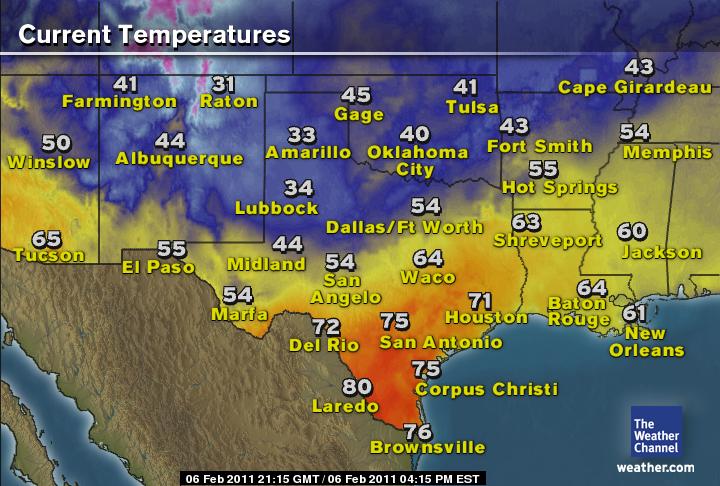
Snow, Ice to Head Back to Dallas, Oklahoma City
AccuWeather
WEATHER TALK
By Mark Vogan
FOR GLASGOW, SCOTLAND, THIS MONTH MAY BE FIRST ABOVE NORMAL METEOROLOGICAL WINTER MONTH SINCE SEASON 2007-08
THE LAST TIME GLASGOW HAS ENDED A WINTER MONTH (DEC, JAN, FEB) ABOVE THE MONTHLY AVERAGE WAS FEBRUARY 2008 WHICH WAS +2F
Both December, 2010 which averaged an incredible 12 degrees below normal (F) and January, 2011 averaging over 1 below normal (F) and December, January and February last season each ending below normal with the greatest departure being over 6 below normal in December 2009, this month appears the most likely to close above normal for the first time season February 2008 which was the last “warm winter”.
It’s currently averaging 4 above normal for the first 5 days and with the current pattern looking likely to stick around, it’s looking highly likely that Glasgow will see it’s first above normal winter month in 3 winters!
VAGARIES OF THE WEATHER
INDIA & SUB-CONTINENTAL ASIA WEATHER
BY RAJESH KAPADIA
Neeraj reports from Kathmandu: “I think a record has been broken in Kathmandu. yesterday’s (Friday’s) high was 26.5 celcius, which is quite unprecedented. Previous Feb Record high was i think 25”
That is a bit high, considering the fact that the normal for this day, 4th. Feb, is 21c.
Well, on checking, I think the Kathmandu record for February is 27c, on a much later date, Feb 26th. 2006. As far as my record search shows, this is the Feb high.
But yesterday’s reading could be an all time high for this day,4th. Feb, the previous high for the day being 23c.
CLICK HERE TO SEE OUR PARTNER’S BLOG FOR GREAT LOCAL MUMBAI, INDIA-WIDE AND SUB-CONTINENT-WIDE WEATHER AS WELL AS INTERNATIONAL WEATHER!
WILD WEATHER ON A WILD WORLD
MEXICO & CONTINENTAL WEATHER
BY ARTURO SALINAS
THIS IS A TERRIFIC ACCOUNT OF NORTHERN MEXICO AND THE MONTERREY AREA’S HISTORIC COLD WAVE OF LAST WEEK, CLICK HERE TO GO DIRECTLY TO ARTURO’S BLOG, GREAT WORK!
AFTERMATH OF COLDEST SPELL IN 30 YRS
This period of cold weather, really messed up with the locals as temps plunged to -6°C last Friday and windchills at some places were as low as -20°C!!
History of the Worst cold wave in 30 yrs

This arctic coldfront began its effects on the region Tuesday when temps began steadily falling by midday once 22°C where reached. By midnight, after really strong gusty winds that created localized blackouts, temps were at 4°C, then Wednesday the temp reached a maximum of 4°C before it suddenly plunged below zero. Thursday was overall the coldest day in years, low temps hovered around -4 to -5°C while the daily max was below freezing!!!!! That day, some flurries were reported downtown and in other higher suburbs while heavier snow fell at Chipinque Park located around 4000 ft asl resulting in a covering. Temps at the park fell as low as -10°C. By Friday, low temps reached in some spots lowest EVER temp in February at -6°C !!!! We had a period of over 36 hrs below freezing, a really unusual condition for the city, and more if it happened at February.

INTERESTING FACTS
Irrigation systems at a downtown park known as Alameda Mariano Escobedo Park were left on in order to avoid ice build up at the pipe lines, resulting in a wonderful scenery in which trees were frozen and this trees lasted in those conditions for more than 36 hrs!
REGIONAL FACTS
Saltillo reached -14.4°C Friday morning, LOWEST TEMP EVER!
Chihuahua, Chihuahua was at a FRIGID -17.7°C!!! THAT’S NEAR 0°F!!
Mountanious communities near the capital of Chihuahua reached below -20°C!
Cd. Victoria was at -2°C!
Tampico, located at sea level and at 22.15 N, reached an outstanding 3°C!!!!!!!!!
Ciudad Juarez was paralyzed by heavy snow, and temps near 0°F!!!! COLDEST SPELL IN MORE THAN 50 YRS OF RECORD.
SLEET AND ICE WERE REPORTED IN TAMAULIPAS, NUEVO LEÓN, COAHUILA, CHIHUAHUA and SONORA!
STRONGEST COLD WAVE AFFECTING A WIDESPEAD REGION OF MEXICO IN OVER 30 YRS.
NEXT WEEK EXPECT A STRONG COLD FRONT.
WHAT’S REACHING TODAY’S BLOGS?
More SNOW
Valley Weather (Montreal, QC Area)
Snow Map for the Snow Today to Tuesday. Winter Pattern Change!
Henry Margusity, AccuWeather
One More Week of Chill Then Warmer
Frank Strait, AccuWeather
THE EXTREMES OF THE DAY
TODAY’S US EXTREMES
COURTESY OF ACCUWEATHER
HIGH: 84 degrees at Homestead, FL
LOW: -11 degrees at Driggs, ID
TODAY’S UK EXTREMES
COURTESY OF THE MET OFFICE
HIGH: 56 degrees (13.5C) at Linton On Ouse (Yorkshire)
COLD HIGH: 39 degrees (3.8C) at Salsburgh (N Lanarkshire)
LOW: 25 degrees (-3.8C) at Aboyne (Aberdeenshire)
TODAY’S EXTREMES HERE AT MY HOUSE
HIGH: 43 degrees
LOW: 36 degrees
Thanks for reading.


")


Recent Comments