>Today’s Top Weather Stories
On Weather & Climate Through the Eyes of Mark Vogan
BOTH USA/CANADA AND NOW UK IN THE ICEBOX!
Record low of 14 degrees for Nov. 24 recorded at Sea-Tac Airport
The Seattle Times
Interior Norway and Sweden enduring -10 to -19C daytime maximums, nights dip to -32C!
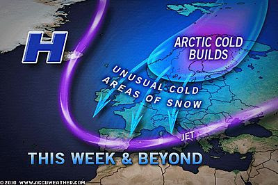
Great Britain begins to feel those Arctic winds blow, conditions set to worsen with first the snow, then the cold
By Mark Vogan
WEATHER WARNING!
AS NORTH WINDS BLOW, THEY SHALL BRING SNOW, BLOWING AND DRIFTING WHICH WILL CREATE HAZERDOUS DRIVING CONDITIONS ACROSS MANY NORTHERN AND EASTERN SECTIONS OF SCOTLAND AND EASTERN ENGLAND
TONIGHT
The far north (Sutherland, Caithness), Invernesshire, Moray, Aberdeenshire, Badenoch and Strathspey, Perth and Kinross may see some heavy snow showers tonight, particularly over higher terrain as north winds begin to pick up through tonight and tomorrow. These snow showers are likely to accummulate to between a coating and a couple of inches through Wed, Thursday and Thursday night, mostly over the eastern half of the country with even Fife and the Lothians experiencing some of this snow as icy winds start to blow harder off of Scandinavia where the air there has gotten decidedly colder with lows falling into the -30sC.
TOMORROW
By tomorrow, not only will many areas have started in the -2 to -4C range over inland areas, icing on roadways will become a problem THROUGHOUT the day as the air temperature really struggles to reach freezing, only areas that see sunlight will see freezing tomorrow and with, at times, gusty winds howling from the north, it will feel bitter (-4 to -10C). Those snow showers that will be generally confined to east coast and higher ground areas may find themselves crossing the southern Highlands and entering the Central Belt, so don’t be suprised if you see the odd cloud that floats by produce the odd flurry or two over the Glasgow to Edinburgh corridor. In fact higher ground ANYWHERE has a chance of flurries or showers. Edinburgh also has a chance of snow showers.
As for tomorrow night and into Friday and Saturday, snow chances increase for the western half of both Scotland as well as England and Wales as the Arctic air deepens over the British Isles. Daytime maximums will become colder and nights “feeling colder” with minimal warming by day and persistent north winds blowing straight from the Arctic tundra. Though -2 or -3C doesn’t seen all that bad, add in even a mere 5 to 10 mph wind and that feels cutting to be outside in.. Up over the Highlands, winds could be gusting to between 20 and 40 mph, therefore windschills may become dangerous as well as blowing and drifting of the snow on the ground, even if it isn’t falling from the sky.
CONCERNS OF A SUBSTANTIAL SNOWFALL OVER MUCH OF SCOTLAND AND NORTHERN ENGLAND COME SATURDAY!
Heavier snow appears more likely across eastern and northern Scotland by Friday and we may see a band of heavier, accummulating snow push down into the central belt with both Edinburgh and even Glasgow, down to Dumfries seeing a covering through this weekend with highs no better than -1 or even -2C, feeling closer to -6 to -8C in the wind!
IN OTHER NEWS
Australia Wheat Harvest to Slow Further with Rain
AccuWeather News
Today’s Weather across America
From AccuWeather & The Weather Channel
Fierce Cold Spreading over Western Two-Thirds of Nation
AccuWeather
Northeast Ski Season Under Way, South Lags Behind
AccuWeather
Thanksgiving Santa Ana Wind Event
AccuWeather
Weather Talk
By Mark Vogan
ANOTHER FRIGID START OVER NORTHWEST US, POSSIBLY COLDEST YET TO COME TONIGHT AND TOMORROW NIGHT FOR CENTRAL ROCKIES, WESTWARDS TO HIGH SIERRA OF NEVADA AND CALIFORNIA
Vagaries of the Weather
India & Sub-Continental Asia Weather
By Rajesh Kapadia
Wednesday, November 24, 2010
The low pressure area over northeast Arabian Sea and adjoining Gujarat Region has become less marked, and the pressure measures 1008 mb.The UAC previously over south Kerala and neighbourhood now has has merged with the above system.
With this, as we witness the Arabian Sea systems now fizzling out, a marked decrease in rains in Mah and Gujarat.
But, a marked increase in rains is on the anvil. In the east. A low is expected to form by tomorrow, off the T.N. coast, and, as a result, the state’s coast shall receive copious rainfall from tomorrow. Chennai is also in for some heavy rains from Thursday evening.
The low will ride on an easterly pulse, and travel west, across T.N. and precipitate rains over Kerala as well on Friday.
SEE OUR PARTNER’S BLOG IN-FULL, HERE!
What’s Reaching Today’s Blogs?
Mixed Bag for Thanksgiving, Dangerous Cold Black Friday
Jesse Ferrell, AccuWeather
Holiday Weekend Highlights
Joe Lundburg, AccuWeather
Abnormal India Rain in November
Jim Andrews, International Expert, AccuWeather
Today’s Extremes here at my house
High: 39 degrees (Coldest High since end of March)
Low: 25 degrees
TODAY’S CONDITIONS
A cold day overall despite sunshine, the breeze blowing out of the north reinforced the chilling feel to what is now Arctic air in place and should remain here for the next week or longer!
Thanks for reading.
-Mark


>I live in Fife and I got a light dusting of snow last night.
I have had enough and I wonder when I can expect it to be warm again.