>For the very latest and most up-to-date info, videos and more that you’ll not find here on the blog, check out the Facebook page and become a fan today! This blog is also on Twitter, become a follower during your visit today…
MARK VOGAN’S VIDEO-BLOG FROM STRATHBLANE, STIRLINGSHIRE, ENJOY!
Today’s Top Weather Stories
On Weather & Climate Through the Eyes of Mark Vogan

BREAKING NEWS
Depression Strengthens into Tropical Storm Danielle
AccuWeather News
LINKS TO THE LATEST NEWS ON TROPICAL DEPRESSION SIX
MARK VOGAN’S TROPICAL STORM DANIELLE DISCUSSION
Tropical Storm Danielle is born and appears to be aiming for hurricane intensity perhaps as early as late tomorrow or Tuesday as it continues on a west, northwest course at around 12 mph, embedded within a easterly flow on the underside of Mid-Atlantic high. This system appears to be within an environment which certainly has warm waters beneath and a weakening shear environment, meaning this system appears likely that over the next 24 to 36 hours, Danielle will become a hurricane.
Series of Troughs May or May Not Effect Danielle’s track
The biggest questions on Danielle at this point in time is whether this storm will recurve in the mid-Atlantic Ocean or will it miss the series of troughs and continue in a more dangerous westerly path towards the US coastline. Each new model run appears to be taking this storm further and further west but I believe the stronger and faster it becomes perhaps a cat 1 to cat 3 storm, may be the decider as to whether this storm recurves of continues westward.
Stay tuned for more updates.
National Hurricane Center:
Tropical Storm DANIELLE Public Advisory
National Hurricane Center:
Tropical Storm DANIELLE Forecast Discussion
AccuWeather Tropical Discussion:
Tropical Storm Danielle
IN OTHER NEWS TODAY

Severe Flooding Hits China and North Korea
AccuWeather News
Nearly 260,000 flee flooding along China-North Korea border
CNN
Flood warnings for southern England and eastern Wales
BBC Weather
South Pakistan villagers flee threatened areas
BBC Weather
Today’s Weather across America
From AccuWeather

More Soaking Rain for New York, New England into Monday
By Kristina Pydynowski, Senior Meteorologist
Stormy Weather Threatens Outdoor Plans in Northeast
By Heather Buchman, Meteorologist
Withering Texas Heat Early Week
AccuWeather
Noticeable Cooling East of the Rockies
AccuWeather
Weather Talk
By Mark Vogan
VERY HOT FROM TEXAS TO THE CANADIAN BORDER!
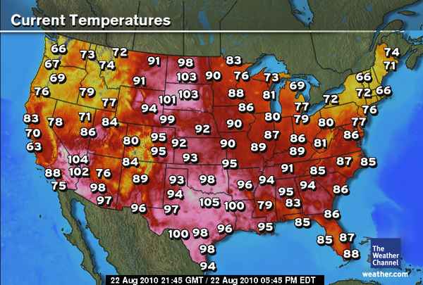
Despite “average highs” falling markedly as we push towards September, the stats often don’t match reality and for sure it’s a hot afternoon across the Plains where highs are between 100-105 degrees as far north as the Dakotas. As for the 105 in Dallas and 96 in Houston, it’s not as bad there as it is across the Dakotas as far as departure from normal when comparing the time of year. What I mean by that is, Texas typically sees it’s hottest part of the year during August, whilst North Dakota will be looking at a sharpening drop-off in “average” temperatures now, but today’s example as well as many other examples don’t match the average! Even Texas is now dropping off their hottest “averages” of the year but like during the spring season when we’re seeing snow and bitter cold in March and April in Texas, we’re seeing the opposite for late summer across North Dakota where they should be seeing warm days and increasingly cooler nights, however, today appears to be a true contender for the hottest day of the summer, yes, not on July 22 but August 22.
Whilst cold fronts will intensify across North Dakota dropping temperatures and nights that may even start to creep towards frost levels, the summer of heat and humidity will continue for the south. A region that starts summer earliest in the US and often ends summer during such a late time that areas way north, but in the same country will begin to see snow flakes fly.
It’s been a long, hot summer once again for Texas and across the South and I do see where temperatures will remain in the summerlike 80s, even 90s all the way towards November and December as La Nina takes hold on the pattern. Southern California, across the South and Florida will see a warm winter this year and perhaps a continuation of summer throughout the winter months in 2010-11.
Vagaries of the Weather
India & Sub-Continental Asia Weather
By Rajesh Kapadia
Sunday, August 22, 2010
91B has come and gone !
Remnants of an erstwhile low, presently at 1004 mb in the southern Bay, hangs around, embedded in an off shore trough line along the Eastern coast south of A.P. With clouding along the trough, we have seen rains in T.N. in the last couple of days.In fact very good rains all over the state have raised hopes , after a weak SWM. Almost reminding the state of the NEM.
Bangalore was drenched with good rains from Thursday/Friday. After rains on Sunday evening, the rains may decrease in the city.
I would expect this low, to deepen and sort of re-form in the same region by 22nd/23rd. But would not expect very heavy rains at this stage.
Now, almost all models indicate the low to linger in the same region, in the sea, till 26th. Around that date, it may enter inland, as a 1000 mb low.
Where ? Normally I would say the A.P.coast. But, as a W.D. (I name it 25W), is crossing the northern region, we could expect the low to be pulled away from the east coast, and move Northerly, and then maybe cross near the Orissa/Bengal coast.
T.N. rains wll decrease , and the persisting low, will result in cloudy weather, but lesser rains in the interiors of the states of T.N. and Karnataka, next 3 days. Thence, all depends on the course of the low.But, I would expect precipitation in pockets to continue in the southern peninsula throughout next week.
See a small vortex, inland forming north of Bangalore on Monday/Tuesday. Maybe some rain in Bangalore on Monday night/early Tuesday.
The same 25W is sure to inter act with the axis, by then in a firm position along the Himalayan foothills, and produce heavy rains from H.P.thru Utteranchal and west U.P. and Nepal. We can expect very heavy downpours along the hills as the axix itself is also at a pressure of 1000 mb.The western end of the axis is saddled in Balochistan, at 998 mb.and will remain firm till the TD off the Vietnam coast survives. Indicating no signs of the monsoon withdrawal from there as yet.
This coming week, more rains for Delhi area after the 25th.
The western coast off shore trough remains weak next week. Normal rains of upto 10/15 mms per day could be expected.
Mumbai: Another few days of less rain.
Monday: Partly cloudy, with sunny intervals. A couple of brief heavy showers.
Tuesday:Partly cloudy, with sunny intervals. A couple of brief heavy showers, especially in the night.
Wednesday: Cloudy with some showers. Stuffy at night.
All days rains will measure upto 10/12 mms per day.
Bangalore:
Monday: Cloudy day, with drizzle. More Rain at night, with thunder. Rain upto 15 mms.
Tuesday: Rains in the a.m. Later cloudy and cool. Rains measuring upto 10 mms mms.
Wednesday: Cloudy with drizzle. rains will measure about 5 mms.
All India Rainfall Toppers From 1st. Jan – 21st.August 2010: (From Pradeep)
Cherrapunji (Meghalaya) – 1140 cm (Annual around 1100)
Agumbe (Karnataka) – 488 cm (Annual over 750)
Gaganbawada (Maharashtra) – 432 cm (Annual over 600)
Shirali (Karnataka) – 351 cm (Annual over 400)
Coochbehar (West Bengal) – 342 cm (Annual around 350)
Passighat (Arunachal Pradesh) – 331 cm (Annual around 450)
Mahabaleshwar (Maharashtra) – 321 cm (Annual over 600)
Silchar (Assam) – 308 cm (Annual around 350)
Honavar (Karnataka) – 307 (Annual over 350)
Ratnagiri (Maharashtra) – 307 cm (Annual around 300)
Buxa (West Bengal) – 302 cm (Annual around 550)
Piravom (Kerala) – 302 cm (Annual around ??)
North Lakhimpur (Assam) – 298 cm (Annual around 350)
Panambur (Karnataka) – 293 cm (Annual over 350)
Mangalore AP (Karnataka) – 292 cm (Annual around 400)
Bhagamandala (Karnataka) – 291 cm (Annual over 600)
Vadakara (Kerala) – 287 cm (Annual around ??)
Karwar (Karnataka) – 282 cm (Annual around 400)
Gangtok (Sikkim) – 280 cm (Annual over 350)
Panjim (Goa) – 273 cm (Annual around 300)
Jalpaiguri (West Bengal) – 268 cm (Annual around 350)
Kottigehara (Karnataka) – 263 cm (Annual around ??)
Harnai (Maharashtra) – 263 cm (Annual around 250)
Mumbai Colaba (Maharashtra) – 263 cm (Annual around 200)
Mumbai Santa Cruz (Maharashtra) – 262 cm (Annual around 250)
Peermade (Kerala) – 256 cm (Annual around 500)
Chinnakallar (Tamilnadu) – 253 cm (Annual around 500)
Kannur (Kerala) – 248cm ( Annual around ??)
Itanagar (Arunachal Pradesh) – 245 cm (Annual around 350)
Matheran (Maharashtra) – 232 cm (Annual around 550)
Kozhikode (Kerala) – 232cm ( Annual around ??)
Kochi AP (Kerala) – 229cm ( Annual around ??)
Dibrugarh (Assam) – 228 cm (Annual around 300)
Valparai (Tamilnadu) – 222 cm (Annual around 350)
Dahanu (Goa) – 215 cm (Annual around 250)
Kottayam (Kerala) – 206cm ( Annual around ??)
Devala (Tamilnadu) – 202 cm (Annual over 400)
READ RAJESH’S BLOG IN FULL HERE!
What’s Reaching Today’s Blogs?
Conflicting Summer Temperatures in the Arctic?
Brett Anderson, AccuWeather
My Fall Forecast
Breet Anderson, Canada Expert, AccuWeather
Today’s US Extremes
Courtesy of AccuWeather
High: 116 degrees at Death Valley, CA
Low: 34 degrees at Portola, CA
Today’s UK Extremes
Courtesy of the Met Office
High: 77 degrees at Cambridge Niab
Low: 43 degrees at Katesbridge
Today’s Extremes here at my house
High: 64 degrees
Low: 51 degrees
Thanks for reading.
-Mark


")


Recent Comments