>For the very latest and most up-to-date info, videos and more that you’ll not find here on the blog, check out the Facebook page and become a fan today! This blog is also on Twitter, become a follower during your visit today…
Today’s Top Weather Stories
On Weather & Climate Through the Eyes of Mark Vogan
THE BLOG IS IN TODAY’S SCOTTISH DAILY RECORD!
Meet the amateur meteorologists who are taking forecasting the weather into their own hands
Daily Record
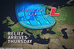
Record Heat in Moscow, but Big Cooldown Follows
AccuWeather News
Major Flooding in Louisiana, SW Mississippi
The Weather Channel
Can Scotland see an Indian Summer?
Mark Vogan (See Weather Talk below)
your america today forecast
by mark vogan
southwest
Today will be another hot one for anywhere generally in from the coast with highs restricted to the 70s along the coast but even a mere 12 miles away from the ocean in downtown Los Angeles, highs should warm towards 95 or even 96, 97 this afternoon and this is thanks to an offshore flow of air that’s moving from desert to ocean, these winds downslope the coastal range and therefore heat up through compression, so summer has finally returned after a 93 yesterday in dtwn LA. As for San Diego, the high should warm to the mid to upper 70s, whilst a mere and perhaps dissapointing 68-70 down San Francisco. The Central and North California coast once again will remain cooler but sun should appear by early afternoon but a substantial sea breeze will hold highs to the upper 60s. As for inland areas, the coastal valleys and canyons will warm into the 90s to even low 100s, including the San Fernando and San Gabriel valleys. The deserts will once again warm to between 105-115 with Death Valley perhaps enduring another high near 121 like yesterday. Both Phoenix and Las Vegas will likely warm to around 106. Most areas from LA (particularly the mountains) all the way east, may see a stray thunderstorms, some of which may be strong and large over the mtns and deserts as a moist southerly flow pushed up from Mexico. This will also may the heat feel worse. Lows range from the mid-50s at the beaches, mid-60s for LA and near 60 for San Diego and San Francisco. 70s for the deserts and 80s for Vegas and Phoenix as well as Death Valley.
northwest
The strong high that brought all the heat to western Washington and Oregon over recent days has now pushed far enough east and south that it’s giving way now for the trough that is bringing a dramatic chance to what you folks in this region has seen. Instead of upper 90s along the I-5 corridor, it will be LOW 70s! Those morning clouds and fog has returned and will thicken up further as a cold pocket of air aloft floats back across the PNW once again and we’ll see some beaches along the coast struggling to see the upper 50s this afternoon as their soaked in by fog and clouds. The mountains will see highs in the 60s, whilst to the east of the Cascades, that’s where it will remain hot with 90s to low 100s. I’m calling for 71 today in Seattle, 78 for Portland this afternoon. Lows tonight cool nicely into the upper 40s to low 50s for the beaches, mid-50s for the cities, 30s and 40s for the mtns and 60s to even low 70s across the eastern portions of WA and OR.
southern plains
Though it’s another hot and very humid day, the change will be a more widespread threat of heavy showers and storms across much of central and eastern Texas in association with the remnants of TD 5. Houston may see a drenching of storms today but highs will once again rise into the mid-90s for Houston and upper 90s for Dallas but it’s going to feel bad out there with all the heat, high humidity and moisture dangling in the soupy, tropical air. Expect lows to fall to the mid to upper 70s tonight across the board.
southeast & florida
An extremely wet day for the central Gulf Coast region as Tropical Depression 5’s remnants create havoc over Louisiana where upwards of 12-15 inch rains are creating major flooding issues, elsewhere spotty showers and storms will blossom particularly for Florida and indeed areas closer to the Gulf, the interior Southeast say from central Louisiana to Columbua, GA should remain mostly dry, but a few storms are always a threat, it should be warm, humid with highs in the 86-91 degree range with some decent spells of sun over particularly more northern areas of the Southeastern states. Lows tonight will remain in the low to mid-70s everywhere.
northeast & mid-atlantic
Today as you’ll notice when looking out either your house or office window that it’s raining, some persistent and at times heavy if your in a region from West Virginia to the Delmarva, including the metropolitan DC-Baltimore area. Showers are also pushing through southeast PA and southern and central New Jersey, whilst it will be more cloudy for Trenton, New York up to Boston, though some showers may advance into this area tonight. Highs should uniformly hold in the low to mid-80s throughout the I-95 corridor, lows tonight staying muggy with dew points in the 60s, even near 70 in spots, this will hold nighttime lows in the 60s for rural spots and low 70s for the cities.
northern plains
Sunny, warm and dry will be the name of the game throughout the Northern tier, under beautiful Canadian high pressure, low humidity and perfect recreational weather with highs generally in the very pleasant upper 70s to low 80s including Minneapolis, Chicago and Detroit, even further south between Kansas City and St Louis, it will stay mild with mid-80s. Lows tonight range from the 50s in the Dakotas, 60s for the Minneapolis to Chicago region and pleasant low 70s for the I-70 corridor..
Today’s Weather across America
From AccuWeather

Flash Flooding Affecting Louisiana to Virginia
By Heather Buchman, Meteorologist
Relentless Severe Thunderstorms Threaten Upper Midwest
By Heather Buchman, Meteorologist
Minnesota Leads Nation in Tornado Reports
By Gina Cherundolo, AccuWeather.com Staff Writer
Flooding Rain Threatening Washington, D.C., Today
By Kristina Pydynowski, Senior Meteorologist
Weather Talk
By Mark Vogan
SURELY SCOTLAND CAN SEE THE SUMMER WAVE GOOD BYE IN THE SAME FASHION IT BEGAN?
Over recent days as I truck between Bathgate, West Lothian and Aberdeen, the sun shines one minute and even feels pleasantly warm, yet the next the rain is blinding. In between those hefty showers I gaze into the beautiful sky which is filled with tall, even towering cumulus, some nearing cumulonimbus levels. evident by their beautiful and towering vertical profile. Enough warmth at the surface is aiding in firing up the thermals, therefore allowing puffy fair weather cumulus which form in the morning to build vertically during the midday hours towards evening. We simply don’t have enough heat at the surface to help build these clouds into thunderstorms as highs are merely falling short of even truely “warm thresholds”. The very cold mid to upper levels has been the mainstay of Scotland’s weather pattern over the past 8 or so weeks and in between waves of low pressure which are spinning down a pipeline, stretching from Iceland to Germany has kept us Scots cool and unsettled, but in saying that, I believe from a personal view point that it’s not been quite as bad as we saw during July, however, like i told the Daily Record in an article published today on page 24 or on their website here, the summer has fallen short of my expectations. The true heat, which I thought we would get, started off not bad but then a big trough swung in off the North Atlantic and put the park brake on over us. This meant all the heat would push to Russia and stay there…. as explained in previous Weather Talk’s, this is why we’re seeing the extreme flooding over in South Asia…
As I open up the window this evening, the moon is shinning and there is even hints of autumn in the air, whether it be the dew forming fast under clear, starlit skies or the smell of wood burning as those nights grow ever cooler. Those late August nights that tend to be clear and cool also tend to be pleasant, even warm and sunny by day when high pressure is firmly settled overhead. Days can warm nicely but the lose of daylight and lengthening shadows mean jackets are required by night. I expect another night to fall back into the upper 40s. In a matter of weeks, we may see nights drop into the upper 30s, even upper 20s for sheltered Highland Glens (between 3C and -2C).
September can often be a nice and pleasant month, providing us one last feel of summer, certainly by day anyway and we may see a period of perhaps a couple of weeks, whether it be broken up or not during September and may provide us with a taste of Indian summer before autumn finally starts to turn those leaves…
My winter forecast for Scotland and the UK to be online here on October 31, 2010.
What’s Reaching Today’s Blogs?
Throwing a Pebble Into the Ocean
Joe Lundburg, AccuWeather
Car Struck by Lightning While Driving
Jesse Ferrell, AccuWeather
Today’s Extremes here at my house
High: 64 degrees
Low: 48 degrees
Thanks for Reading.
-Mark


")


Recent Comments