>Today’s Top Weather Stories
On Weather & Climate Through the Eyes of Mark Vogan
iceland, europe
Ash cloud from Iceland’s Volcano to grow Sunday
AccuWeather News Here
new york, u.s.a
Staten Island Ferry crash injures 55
CNN Here
Cooling Relief and a brief return to normal
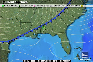
Upper 80s to near 90 have been the story for New Orleans and throughout the Gulf Coast of late, yet a cold front was able to push far enough south to cool things off along the Gulf Coast where temps and humidity have been somewhat mid-summer-like rather than early May-like. The high only topped 82 rather than 87-88 in New Orleans with a wind flow turning from southerly to northerly, pushing cooler, drier air into the region and making things much more pleasant. A southerly flow always pumps hot, humid air up from the tropics making things feel uncomfortable, but at this still early stage in the summer, we can still see those cold fronts penetrate the Gulf Coast and remove that ever more dominant southerly Gulf flow. However it never takes long before winds return from the south and things heat and sweat up! Atlanta even enjoyed a day only in the 70s with drier air covering much of the Southeast as the front pushed southward and will be out over the Gulf of Mexico tomorrow… Will it manage to hit South Florida where upper 80s to low 90s have been the rule. In fact parts of South Florida managed to hit 95 degrees!
By tomorrow much of the Southeast US will only see highs of around 70 in Atlanta and only 80 in New Orleans, a good 8-10 degrees below what they have endured of late and the air will also be much more refreshing and less sticky.
Today’s Weather across America
From AccuWeather
Damaging winds blast the Northeast
AccuWeather Here
High winds to whip California deserts, Four Corners
AccuWeather Here
Oil slick may spread with shifting winds
AccuWeather Here
Weather Talk
By Mark Vogan
LATEST SUBZERO LOW FOR THE USA IN AT LEAST 10 YEARS
Usually the coldest temperatures found across the lower 48 in April and May are found within, remote, highly-elevated mountain valleys or basins of the American West where the air is drier and thinner and thus though warm by day, there is a substantial cooling after sunset when skies are clear and winds light, the thin, dry air helps support cooling faster than air at lower elevation and that is wetter. Moisture holds heat, which explains why many areas east of the Rockies and succeptable to a Gulf flow tends to see see cooling at night.
Sometimes when a trough is drapped over the West, right over the mountains and sheltered high-elevation valleys and basin which tend to experience sinking of air down surrounding mountains after sunset, can experience very cold spring nights and in some cases sub-zero (-18C) readings can be found even into April and in some cases, though, more unusual, May!
It is unusual to see lows fall all the way to zero degrees by May because nights are so short, days are long an warm much more efficiently. Air masses are warmer also and cool air masses are both harder to come by once the Four Corners high becomes well established. Those Arctic cold pools of air that were once so strong in mid-winter, but usually areas of very cold air “aloft” and can and do force “chilly” air down to the surface which results in snow even at relatively low levels in the Rockies. This can be experience anywhere from Montana, to South Dakota’s Black Hills all the way to the mountains of New Mexico and Arizona well into May when large troughs block off the natural progression of the building Four Corners high which delivers such intense summer heat to not only the American West but across all of America from time to time.
Yesterday, saw an unusually cold low of 0 degrees at a typical late season cold spot, Lake Yellowstone in Wyoming. Often the latest sub-zero low is last reported in places such as Bodie State Park, California, Lake Yellowstone, Wyoming or West Yellowstone, Montana, in early to mid-April. Recent lows in this very region is seen lows creep below 10 degrees, frigid for May for sure and the location has bounced between Lake Yellowstone and West Yellowstone, both within the park and either just over the Montana line or Wyoming line.
Latest Sub-Zero US Lows since 2000 according to USA Today Data
2010: May 7
2009: April 3
2008: May 3
2007: April 10
2006: March 27
2005: April 29
2004: March 24
2003: April 7
2002: April 4
2001: April 3
2000: March 24
As you can see, according to this data from the USA Today, since 2000, we have only seen two years in which a low of zero or lower has been reported in May and this year, 2010, is the latest in at least 10 years for the lower 48.
More on this story tomorrow!
What’s Reaching Today’s Blogs?
Day Temperatures in North India now in the Below Normal Region
Vagaries of the Weather Here
Pennsylvania Nightime Lightning From May 8th Storms
Jesse Ferrell, AccuWeather Here
Today’s US Extremes
Courtesy of AccuWeather
High: 99 degrees at Blythe, CA
Low: 4 degrees at Burgess Junction, WY
Today’s UK Extremes
Courtesy of the Met Office
Warmest High: 60 degrees at Crosby
Coolest High: 44 degrees at Liscombe
Coolest Low: 21 degrees at Braemar
Today’s Extremes at my house
High: 61 degrees (This is an unofficial reading which beats the “official” warmest temp in Britain)
Low 37 degrees (7 degrees below the average low of 44)
An overnight wind kept temps up but in areas only a mile or so away saw frost on cars and grassy surfaces, winds were likely less in these areas and a good illustration of the “micro-climate”.
Follow this blog on Facebook & Twitter
Thanks for reading.
-Mark


Recent Comments