>18 March, 2009: Continent of Contrast Part 2: Why No EXTREME Cold in a Coldest Winter for 25 years?
>
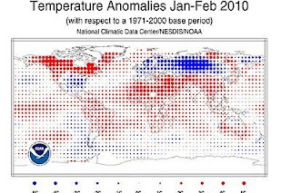
As you can clearly see from the above chart 1) there is a lot of red covering this map and 2) there was very warm over cold across North America. Note the deep blue across the heart of north-central Asia? Most of Europe was either cold or very cold, particularly from Germany to Ireland where here it was the coldest since 62-63 for Scotland and for Britain as a whole it was the coldest since 78-79.

Whilst Western Canada was shivering in early December when Edmonton endured one of it’s coldest temperatures on record of 51 below zero F. The eastern US wasn’t all that bad, so despite the very warm OVERALL winter for Canada, it wasn’t a winter dominated by day after day for 3 months of 60 to 70 degree weather that’s for sure.
What really happened was that this winter’s pattern which occurs every so many years was charged by a collection of large-scale cycles, features, events large and small which has forced this kind of winter.
1) The return to a Cold Pacific Decadal Oscillation.
2) 10 or so years where the earth has stopped warming
3) An increase in “high latitude” volcanic activity
4) The development of the El Nino
5) The warm, cold warm North Atlantic temperature profile
6) Solar Minimum
All of the above has likely played a role, some with greater effect than others. When looking at an El Nino occurance during a “Cold” PDO, this has a different influence globally to when there is a Warm PDO.
The El Nino apparently went to strong moderate to borderline strong but it was centered over the “central” Pacific, crucial to feedback of the trough-trough positions over the US and hemisphere.
A reduction in overall global temperature I believe means that this, combined with a low solar cycle or indeed with us in the midst of a low solar minimum, this allowed greatly potential for cold to form and build over the Arctic during last autumn and the record Arctic Outbreak across the American West in October 2009, showed me, the abilility there was for cold to build hard and fast.
Combine the a central Pacific centered El Nino, low solar cycle, increase in volcanic activity and you had the prime set up for great winter conditions, which depended upon where the mean ridge-troughs set up.
When would the Arctic and North Atlantic Oscillstions would flip negative or positive determined when the major cold or mild spells would hit.
Volcanic activity in the Arctic region likely was responsible for major blocking over the pole and North Atlantic which ultimately drained early season cold out of the Arctic (remember the warm, very wet November for the US and Western Europe?) That was when the Arctic was loading with cold. Then the flip occured and the stratosphere warmed dramatically, forcing all the cold south by mid-December 2009.
That was it… The cold was there to stay for Western Europe and the US West was feeling the cold… The troughs were taking their position as the AO turned negative, so too did the NAO forcing the deep, Arctic air over Britain and W. Europe.
This overtime spread or fanned out and the blocking highs over Greenland and Canada also fanned out, ultimately anchoring in the cold which meant a prolonged period in the freezer. As the warm pool warmed the north of Canada, Alaska and Greenland, this meant they wouldn’t cool until a flip to positive AO could occur.
Why then with all the cold over Europe, Asia and the US with the core of coldest being forced from the west to central and finally to eastern US not mean extreme and brutal lows?
I personally believe the reason for sustained cold was volcanic activity which prolonged the locked pattern from the blocking ridges which intensified through time and through the winter as well as the continued development of the El Nino which kicked in, feedback and reinforced the same ridge-trough positions only, they were in the spots that may typically occur during a central Pacific centered El Nino, the difference was the Cold, rather than warm, the low solar cycle and volcanic activity INCREASED not only the amount of cold but also availability of cold…
The progression of cold eastward and southward in the US as winter progressed into February was the reaction to El Nino and the beefing up of storms across the southern storm track… the south and southeast advance of cold into the southern and eastern states is explained by the deepening warm pools across the northern latitudes.
The AMOUNT of cold combined with an abundantly moisture southern flow, meant the perfect winter for snow in the east. The warm, cold, warm over the N. Atlantic and off the East Coast allowed the “bombing out” and massive snow totals during the February fury of blizzards.
So why no extreme cold? Yes, like explained already, it was a cold, long and tough winter. Worst in 25 years but I was dissapointed by the actual minimums found, particularly across known cold regions. My theory is Europe seemed to have the core of coldest as well as Asia and with Asia, Europe and the US all exteriencing sustained cold, well perhaps it was covering too broad an area and unlike recent years, the cold was not confined and ultimately stronger…

This article will likely be added to…
Thanks for reading.
-Mark
(Images courtesy of NOAA)


Recent Comments