>2009 as expected by various groups of a down year which indeed was the case. With several factors in force which included.
WHY THE DOWN YEAR IN 2009?
1) strong easterlies which not only can move thunderstorm clusters westwards too fast and therefore these thunderstorms that form can’t group and develop, also and probably the biggest factor was these strong easterly trade winds drew (2)vast and persistent plumes of dry air off the African continent and also the Sahara Desert and this was pulled by the trades into the tropical storm breeding belt ultimately chocking essential water vapor that is vital for thunderstorms to begin maturing into low pressure centers and, even more water vapor is needed for further organising into a tropical system structure through the depths of the atmosphere, warm extremely moist air along with very warm to even hot water to depths of 100 to 250 feet below the ocean surface is the two key ingredients for tropical storm/hurricane formation. This injection of dry, dusty desert air is and was the ultimate killer in tropical storm/hurricane production in 2009 therefore limiting storm development in a sporadic way. (3)Wind shear, also a factor but not as much as many believe, was created by the strong easterlies and also varying winds coming from differing directions above the stronger than normal easterlies ripping along below the mid to upper level north and north-west winds which blew hard at times.
The later point in the above brings me to what I believe was another major prohibiting which may have not been mentioned in other post-hurricane season 2009 annalysis was in relation to what the weather was doing over the North American continent, their cool summer saw cool Canadian highs push further south than normal and therefore the jet stream was forced far south over the continent of North America and therefore out over the Atlantic which brought shear but also protection from the storm that did manage to form and devleop. Though it was a downyear and the tropical Atlantic was a very hostile environment compared to normal we did still see 9 named storms, 3 hurricanes and 2 of them did become major and some did threaten the US East Coast as a hurricane but were forced offshore by between 100 to 200 miles, this was thanks to the jet stream being forced farther south and east than what’s typically seen during the heart of the American summer and this brought the first July without a single 90-degree day at New York’s Central Park in some 15 years, same for Minneapolis and it was the coldest July on record for some Ohio Valley locations.
Another aspect of the downyear was a cooler Tropical Atlantic(which lessed potentially developing systems with less fuel), thus added to the prohibiting factors already mentioned.
2008 was a different story but what again played a role was not only the storm track location which drove many into Haiti and the Dominican Rep as well as Cuba which I believe weakened and unfortunately from these tropical islands was the saving grace for the US… But waters in the Gulf were slightly cooler and I do feel that despite the weakening over the high mtns of Haiti and Cuba, reformation of these hurricanes did not occur because depth of warm water in the central and eastern Gulf was not as high and therefore intensification was limited by the lack of potential energy.
Unfortunately it was still bad enough with Gustav and Ike causing major problems for the central Gulf Coast, of course Dolly in July caused big problems to the lower Texas coast.
Incidentally, non of these storms actually were cat 3’s or major at landfall and therefore Wilma in 2005 remains the last storm to impact the US coast as a major storm….
What about 2010?
I am not going to issue my own actual forecast but merely throw out to you the factors that may drive this years hurricane season….
What’s a concern?
1) The tropical Atlantic is warmer this year than the last couple of years..
2) The weakening of the El Nino and the fact it should be neutral by the heart of the hurricane season means pressures over the Atlantic could become very conducive for development and mantainance of storms.
3) An El Nino that has occured adds water vapor across the world as warmth is releasing through the occurance of an El Nino (reason for the spike in global temps). This increase in water vapor, combined with lower than normal pressures across the tropical Atlantic means a good setup is occuring for this season.
May is often a crucial month and often May is the month that sets the stage to an upcoming season. I do see a busy year and a big impact year onlong the US coast with anywhere from Texas to Maine at risk…
Those are my initial thoughts from what’s on the table but I am not really going to issue my own personal forecast for this years hurricane season but merely discuss the varying aspects that will build this hurricane season. I will also be providing full coverage if/when a hurricane threatens the US coast.
For more detailed info on the hurricane season, I strongly suggest looking at Joe Bastardi’s hurricane forecast as this will provide you with more information…
Click here: http://www.accuweather.com/blogs/news/story/25984/joe_bastardi_more_active_2010_1.asp
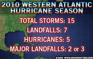
Here is AccuWeather’s forecast!
 (Graphic courtesy of AccuWeather.com)


Recent Comments