
United Kingdom & Ireland

Here’s a positive indicator. Siberian snowpack is growing faster as of October 1 this year compared to last. Thank a strongly negative Arctic Oscillation. [s2If current_user_can(access_s2member_level1)] Expect snow cover throughout Eurasia to continue expanding westward. That negative Arctic Oscillation is helping feed some pretty chilly early season Arctic Russian air across Europe beneath a sprawling Scandinavia blocking high. […]

We are firmly under the influence of a monster Scandinavia ridge and will continue to be through the upcoming weekend. A low running the SE flank and drifting into Poland will enhance the ENE flow and while likely bringing snowfall to some, I expect chillier air to reach the UK late week as the nagging […]

After what was a very warm September, the current Scandinavian blocking high is favouring a cold October for much of Europe. The core of the high reached 1050mb at the surface over Sweden this morning. A low drifting WSW on the underside of the high is pulling Arctic Russia sourced air into the heat of Europe. […]

The upper air pattern turns much more meridional or amplified this week as a Scandinavian blocking high builds and expands. The core of this huge high nears 1050mb this week. It’s affects are being felt throughout the UK and Ireland and as far east of Russia and Kazakhstan. This large boulder in the upper air stream reroutes […]

[s2If current_user_can(access_s2member_level1)] There’s a lot of question marks and complexity surrounding the upcoming winter of 2016-17 for Europe. There’s nothing clear cut when forecasting winters here but this year is particularly challenging. Sure, the El Nino ruled last year but post El Nino winters have been known to have quite the sting but the ENSO […]

Following the frequent showers of today across England and Wales, tonight looks to be Scotland and Northern Ireland’s coolest since spring thanks to the sunshine of today giving way to starry skies tonight. Clear sky, light wind, a cool air mass and nights now longer than days all contribute to much more effective radiational cooling. Rural areas will dip into low single figures […]
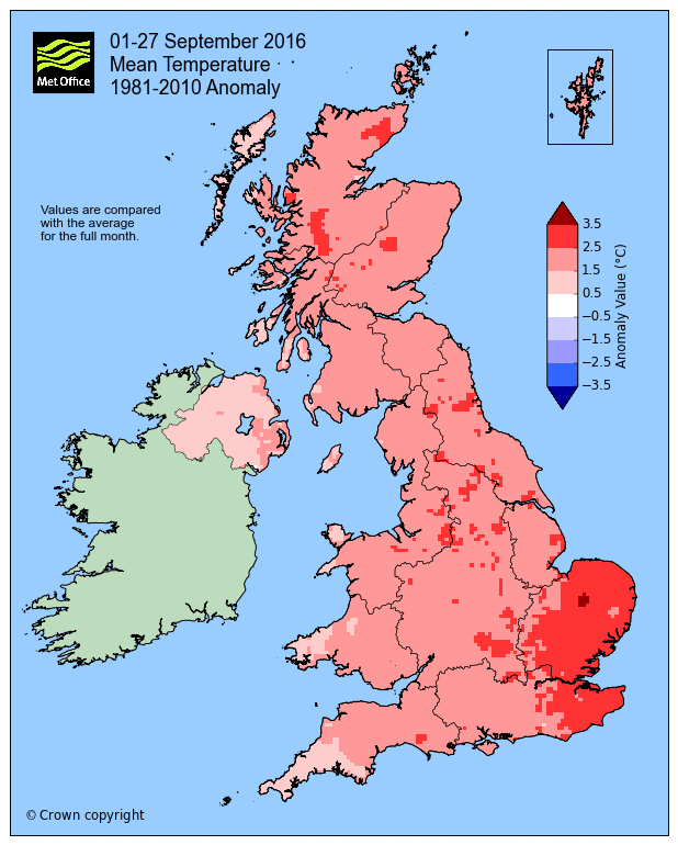
From Met Office Despite a mixture of weather across the UK, two warm spells around the 9th and 13th of the month have helped boost temperatures, with this September on track to be the second or third warmest for the UK since records began in 1910. Provisional stats up until 27 September show the mean […]

FROM MET OFFICE From Sunday 10 to Monday 11 August 2014, the UK experienced some unseasonably windy and very wet weather from the remnants of ex-hurricane Bertha. Some locations in north-east Scotland received double the August long-term average rainfall, resulting in significant flooding problems. Parts of eastern England were also affected by this storm. Impacts […]

Severe gales are pulling away from mainland Scotland and focusing on the Northern Isles now as the low departs. FEATURED IMAGE CREDIT: Jamie Ormiston @Jamieo_edu [s2If current_user_can(access_s2member_level1)] The current undulating or wavy Atlantic jet stream is making for a ‘no two days are the same’ scenario with the current low exiting and another approaching Ireland and focusing on England and […]

I am delighted to announce that my wife Karen and I are expecting our second child. This morning’s 20 week scan went well and baby and mum are doing just great. Due in February!
Recent Comments