>
Join The Conversation!
In Today’s Blog
Latest UK-Europe Discussion @ #UK-EUROPE
Plenty Of Active Weather Across Europe Through Next 7-10 Days
US LATEST
Special Coverage Of This Weekend’s Severe Weather Outbreak
Today Is A Dangerous Day To Be On The Plains

Are you ready, prepared if a tornado was to come through your neighbourhood tonight?
Follow Updates Via FACEBOOK & TWITTER!
THREAT FOR LONG-LIVED, LONG-TRACKED AND POWERFUL TORNADOES REMAINS HIGH INTO TONIGHT
Up until now, the tornadoes which have formed have largely impacted rural areas but as we enter the much more dangerous overnight hours, the threat for cities being hit increases.
The risk for dangerous, long-lived, long tracked tornadoes remains very high tonight and of course the danger aspect increases because these beasts cannot be seen. I urge you to have your NOAA radio on at all times through the night and be aware of the weather off to your southwest as most super cells are firing and running northeastwards.
Also be aware of newly forming thunderstorms and the rapid transition into dangerous supercells. The atmospheric environment is highly conductive through tonight with PDS tornado warnings now extended into the overnight period.

Live: Major Tornado Outbreak from Nebraska to Oklahoma
LIVE FEED
– SAWYER, KS residents take cover now! tornado on ground within a mile!
– Confirmed tornado near Macksburg, IA.. Very dangerous in Winterset & Patterson..
– Multiple strong cells pushing northeastwards across SE Nebraska. Auburn has dangerous cell moving towards you!
– 2nd ‘Particularly Dangerous Situation’ issued for eastern Neb
Particularly Dangerous Situation (PDS) Tornado Watch 165
ACCUWEATHER: Live Tracking: Watch the Tornado Outbreak on Radar
LATEST FROM NETWORKS
Tornado sirens sound in Oklahoma City amid warnings of ‘life-threatening’ storms
NBC NEWS
VIDEO: April Snowstorm Looms
ACCUWEATHER
Yesterday’s Storm’s In Oklahoma
Storm Which Will Bring Major Outbreak Across Plains Today Caused Quite A Stir In California

Chilly Storm Moves Through California
THE WEATHER CHANNEL
Grapevine reopens as record-setting rainstorm moves out
LA TIMES
I-5 over Grapevine reopens after freak spring storm
BAKERSFIELDNOW
EUROPE LATEST
Plenty Of Active Weather Across Europe Early Next Week
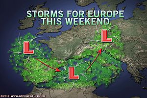
The ECMWF model is busy with active pattern evolving across the UK and Ireland and really the majority of Europe will see a pretty unsettled, cool pattern over the next 10 days.
From Spain all the way to Turkey and most points in between have seen plenty of wet weather and can continue to expect hefty showers, thunderstorms along with cool temps over the next 48 hours. Northern Italy up through the Alps will see heavy snows. Read More!

Much-Needed Rain Approaches Europe
ACCUWEATHER
Waterspout Captured Off Bray, Ireland
Flooding In Flooding in Orihuela, Spain
Photo courtesy of Meteo Orihuela

ASIA LATEST
Sumatra quake reveals new seismic information
CNN
THE EXTREMES OF THE DAY
TODAY’S US EXTREMES
COURTESY OF ACCUWEATHER
HIGH: 97° at Laredo, TX
LOW: 14° at West Yellowstone, MT
TODAY’S UK EXTREMES
COURTESY OF THE MET OFFICE
HIGH: 55° (12.7°C) at Plymouth (Devon)
LOW: 24° (-4.3°C) at Saughall (Cheshire)
TODAY’S EXTREMES HERE AT MY HOUSE
HIGH: 52°
LOW: 35°
Thanks for reading.
-Mark


Recent Comments