>
Join The Conversation!
In Today’s Blog
**MUST SEE VIDEOS BELOW FROM YESTERDAY’S SEVERE STORMS ACROSS PLAINS
Latest US Discussion @ #USA
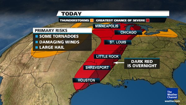
More Severe Storms Today, Risk Area Slides East, Watch Out From E Texas Up To E. Minnesota & All Of Wisc (Detailed Explaination To Atmospheric Set-Up)
Latest UK-Europe Discussion @ #UK-EUROPE
Dry, Settled Monday In Store But Turning Very Wet & Windy Tuesday For Ireland, UK (Includes Video)
Latest Weather from India-Sub-Continent @ #INDIA-SUB CONT
Latest India, Sub-Continental Weather By Rajesh Kapadia
US LATEST
Another Day With Life-Threatening Tornado Risk, Area Of Concern Shifts East Following Deadly Night Across Okla
DANGER ZONE FOR SEVERE/TORNADIC THUNDERSTORMS
E. TEXAS, E. OKLAHOMA, N,W LOUISIANA, ARKANSAS, MISSOURI, ILLINOIS, IOWA, E. MINNESOTA, WISCONSIN, MICHIGAN
MINUTE-BY-MINUTE SEVERE WEATHER COVERAGE STARTS TONIGHT AT 7PM CENTRAL & 8PM EASTERN VIA MY FACEBOOK & TWITTER FEEDS…
Expert Discussion By Mark Vogan
INCLUDES: IN-DEPTH EXPLAINATION TO THIS TURBULENT ATMOSPHERIC SET-UP
Very Warm Weather Over East Today, Even Warmer Monday

Think it’s warm today in Mid-Atlantic, Northeast, think again!.. With the high sliding off the coast and the cold front sliding towards the Appalachains, the blazing April sun, strong southwest winds and the effect dry soils have on the lower atmosphere means it’s highly possible to see 94-95 in Washington DC, 92-93 in Philadelphia, 91-92 in New York City and even 90 in Boston during Monday.
LATEST FROM THE NETWORKS
At least 5 dead after a day of twisters, storms, severe weather may continue Sunday
FOX NEWS
At least five dead as tornadoes hit Midwest and Plains
NBC NEWS
Twisters kill 5 in Oklahoma; tear through Kansas, Iowa
CNN
At least 5 dead from Saturday’s tornadoes in Oklahoma. Damage also in Wichita, KS and Thurman, IA (The Weather Channel)
Danger Zone Today!

You Tube Video Capturing Yesterday’s Severe Storms
Hail & Highwater In Norfolk, Neb
EUROPE LATEST
Dry, Settled Monday In Store But Turning Very Wet & Windy Tuesday For Ireland, UK
GFS has 974mb low crossing Ireland on Tuesday
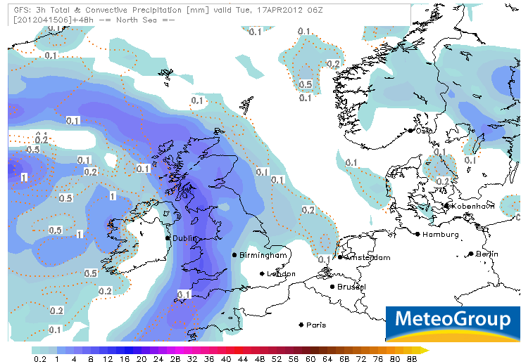
After a Saturday dominated with partial cloud/sunshine across a large part of Ireland and the UK, hefty showers and thunderstorms blasted parts of the South, particularly over the Southwest of England. Today will be a lot quieter with a very nice but cool day across the board. The northerly breeze will make it feel quite chilly, especially Scotland but where there is less wind and the sun shines, it feels very comfortable.
Monday should be similar to today with good spells of sunshine but it’s all change Tuesday as an Atlantic storm system deepens rapidly on approach to Ireland. Read Full Details!
AUSTRALIA LATEST
Tropical Moisture Flows Into Queensland Bringing Heavy Showers, Cooldown For Perth While SE Is Warm
THE EXTREMES OF THE DAY
TODAY’S EXTREMES HERE AT MY HOUSE
HIGH: 50
LOW: 27
Thanks for reading.
-Mark


Recent Comments