>
Join The Conversation!
VOGAN’S VIEWS ON EUROPE IS NOW AVAILABLE (SCROLL DOWN)
Today’s Global Weather Headlines
Europe Latest
Mild Atlantic Air Continues To Bring Rain Across Parts of Ireland, NI, Scotland, NW England, Elsewhere Drier But Mostly Cloudy, Mild

The rather persistent, strongly Atlantic influenced pattern continues through Ireland and the UK with rain pushing in aboard a pronounced southwest flow which marks the seperation between colder air to the northwest and milder air to the south. This southwest air over Ireland and the UK is drawing air from the sub-tropical Azores and with this air travelling across the ocean, it’s bringing in those heavy clouds, stiff southwest breezes and the rain, especially to northern and western areas where heights are lower and where the air mass convergence is nearest. From the Midlands down through southern England, pressure heights are slightly stronger and therefore conditions are a little more settled. The main difference really is that there is less rain and in coming days, temperatures will be warmest with widespread 13 to 15s C.
Danube River Ice Crushes Boats, Piers
Amazing Ice Smashup on the Danube
ACCUWEATHER.COM
Rapid thaw brings chaos to River Danube
BBC
Flood Potential Grows As Temps Warm Across Frozen Europe

If you think the above Danube ice flows which are crushing boats and piers along it’s banks is bad, think again. I am particularly concerned about the valley communities nestled within the Alps of North Italy, Austria and Switzerland as well as from central Italy through the Balkans (especially Serbia, Bosnia), Bulgaria, Romania, Ukraine and southern Russia where the snow depths remain extremely deep.
The best we can hope for is that we see a gradual warming trend as we progress through March and April but the significant threat will continue throughout the spring, possibly even into early summer given the shear volumne of water locked within this snowpack.
Southeast Europe Flooding Potential
ACCUWEATHER.COM
US Latest
More Severe Weather Concerns Before Decent Shot Of Arctic Air Decends Upon The N. Plains, Midwest And Eventually Northeast

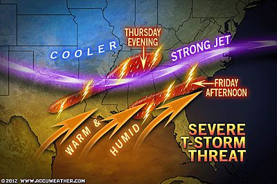
A strong jet which seperates cold air driving south from Canada and increasingly warmer, moister air from the Gulf of Mexico will intensify an eastbound system which moves into the Ohio Valley Thursday, setting the stage for a severe weather outbreak across the South. This system will help pull in and wrap around it’s center, the warm, cold, dry and moist air which will increase the severe weather threat in it’s warm sector out ahead of the associated cold front.
A powerful subtropical jet will act like a hose of sub-tropical moist air, injecting further energy into an already unstable atmosphere and this means, Thursday night into Friday, a substantial severe weather threat looms from Texas to the Carolinas. Flooding rains, damaging winds, large hai, flooding rains and even tornadoes are possible with this setup.
As the cold front sweeps through a region from Texas to the Carolinas, out ahead of that front, warm, humid air will help juice up the lower atmosphere which will rise into the colder air aloft. The warmer, moister the lower atmosphere, the stronger the upward motion. This air which may reach the upper 70s to low 80s combined with much colder, overriding air will sharply increase the lapse rate and CAPE VALUES. The contrast also increases the spin of the storm’s circulation which in turn increases spin of the atmosphere in which these storm form within and that only means one thing.. Building thunderstorms will have plenty of spin to turn into supercells…
South Flash Flooding, Storm Risk Thursday, Friday
ACCUWEATHER.COM
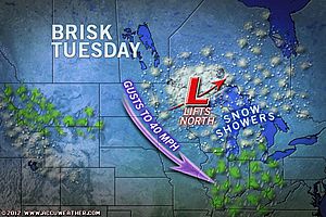
Snow, Howling Winds Continue Today
ACCUWEATHER.COM
VIDEO: Unsettled but Mild Week in East
ACCUWEATHER.COM
One Dead As Severe Storms Tear Across Okla.
THE WEATHER CHANNEL
4.0 earthquake in Missouri shakes 9 states
NBC NEWS

Earthquake Rattles Missouri, Illinois, Tennessee, Kentucky
ACCUWEATHER.COM
One U.S. Town Struggling with Too Much Snow
THE WEATHER CHANNEL
Above-Normal Tornado Amounts Expected in 2012
ACCUWEATHER.COM
Africa
Atlas Mountains of Algeria Got Hammared By Heavy Snows During Europe Coldwave
VIDEO: Snowbound in Africa
ACCUWEATHER.COM
Australia Latest
Dangerous West-East Line Of Storms Bringing Flooding Rain, Severe Weather Across Queensland
THE EXTREMES OF THE DAY
TODAY’S US EXTREMES
COURTESY OF ACCUWEATHER
HIGH: 82° at Harlingen, TX
LOW: -12° at Clayton Lake, ME
TODAY’S UK EXTREMES
COURTESY OF THE MET OFFICE
HIGH: 58° (14.2°C) at Kinloss (Moray)
LOW: 34° (1°C) at Rothamsted (Hertfordshire)
TODAY’S EXTREMES HERE AT MY HOUSE
HIGH: 49°
LOW: 47°
Thanks for reading.
-Mark


Recent Comments