>
Join The Conversation!
NEW LONG RANGE VIDEO BELOW….
Today’s Weather Headlines
Europe & Long Range Latest
Arctic Chill Sweeps Europe This Week

Expert Discussion
Arctic air builds south from Scandinavia into eastern Europe all the way down to the eastern Mediterannean bringing sub-freezing days to many towns/cities through the Baltics, Russia, Ukraine, Romania, Bulgaria, Turkey, Balkans early week, then Germany, Poland, the Alpine countries and even northern Italy and Greece also, eventually reaching eastern Belgium, Netherlands into France and then by next weekend, the UK and interior Ireland.
This is how I think this week will progress and change.
Look for milder air getting shoved northeastwards via a pumping ridge early this week over Ireland, UK and western mainland as this forces the eastern trough to deepen to the east and ingest colder and colder air down from Scandinavia. However, a trough out over the Atlantic will also fill with cold air from off Greenland, deepen and then get tapped by an Atlantic low which trecks across the ocean, pushing across the UK-Ireland and western mainland Thursday. Remember there’s a split going on with the jet this week with a northern branch heading up over top of Scandinavia and another down over the Mediteranean. Once this system pushes into western Europe, a trough develops on the backside . As it does so, it’s important not to focus on the trough development over the western continent with colder air spilling down into the UK-Ireland from the northwest but what’s happen to the cold pool to the east. BTW, the cold deepens throughout this week, likely to be not seen by the models (cold air is heavier than warm, so it sinks and that nature of low-level cold air is often not seen by forecast models). The deepening of the trough in west raises heights further east and thus the cold pool lifts northwestwards up into Scandinvaia, but once a few lows within the trough slides east, then the door of that intensified cold ARCTIC air will be allowed to bleeds south into the UK-Ireland. The upper pattern between Monday-Tuesday and Friday-Saturday will have completely flipped, just like a seesaw with warming in east and cold in west, but what I think modelling may not pick up on until too late will be the dislodge of that Arctic chill from Scandinavia down into the UK-Ireland by Sunday, making for a major shock to the system for most.
US Latest
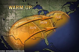
Very Cold Start Across Northeast, Warmth Crosses Country Ahead of Even Colder Arctic Blast Next Week

Temperature Roller Coaster to Affect the East This Week
ACCUWEATHER.COM
Heavy Snow For Seattle, Washington?
The infusion of both Arctic air drawing down from Canada and an incoming moist Pacific system, begs the question, will Seattle, Portland get in on some heavy snow? It appears they may well do.

Ingredients on Deck for Historic Seattle Snowstorm
ACCUWEATHER.COM
Seattle Snow, Storms to Return to the West
ACCUWEATHER.COM
Canada Latest
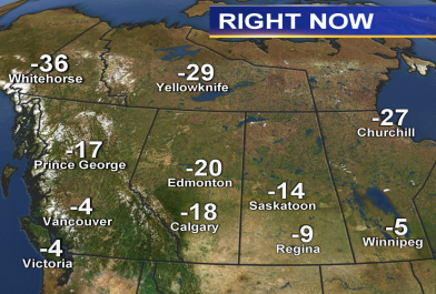
Good Old Fashioned Arctic Blast Coming For Much of Canada This Week
Prairies brace for plunging temperatures
THE WEATHER NETWORK
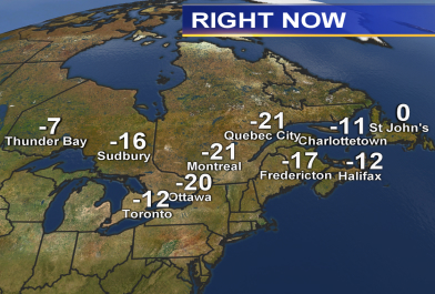
Very cold late morning across east but coming days will moderate while it will turn colder and colder in west
Looking at Arctic Blast This Upcoming Week, How Cold?
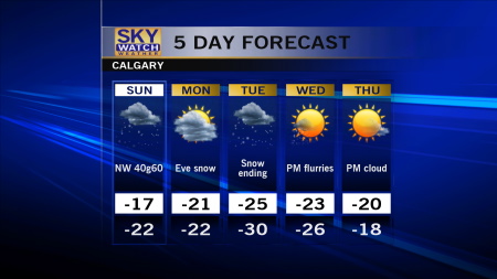
The arctic hound is roaring southwards and with a system treking eastwards around the southern boundary of the the frigid arctic pool, snowfall is breaking out across the southern provinces of British Columbia, Alberta and Saskatchewan bringing anywhere from a few cm’s to Vancouver to between 6-20cm further east. Over the next 36 hours, this system will be off to the east and therefore the door to the arctic opens up. Highs in both Calgary and Edmonton will struggle by midweek to reach -30C (-22F) while nights under clear skies and light winds may approach -38C in Calgary and -40C in Edmonton, the intensity of the low level arctic air is likely underplayed by some models and thus it could well be even colder air sweeping south than many realise.

THE EXTREMES OF THE DAY
TODAY’S US EXTREMES
COURTESY OF ACCUWEATHER
HIGH: 78° at Harlingen, TX
LOW: -24° at Watertown, NY
TODAY’S UK EXTREMES
COURTESY OF THE MET OFFICE
HIGH: 48° (8.8°C) at Isles of Scilly
LOW: 15 (-9.4C) at Aboyne (Aberdeenshire)
TODAY’S EXTREMES HERE AT MY HOUSE
HIGH: 34°
LOW: 23°
Thanks for reading.
-Mark


Recent Comments