>
Join The Conversation!
LONG RANGE VIDEO NEW AVAILABLE.. SCROLL DOWN!
Today’s Weather Headlines
US Latest
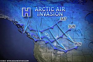
Arctic Air That Will Shiver and Shock Both Northeast Sunday and Plains Next Week!
While an arctic high drifts from Ontario, Quebec into New England during Sunday holding highs throughout the I-95 corridor in the 20s, despite a lack of snowcover, it’s possible that Boston dips to near 0 degrees by Monday morning while New York City nears 10 degrees and Philly, Baltimore and DC dips to between 11-14 degrees (F).

Mark’s Forecast lows tonight (F)
Caribou, ME -15
Boston, MA 10
Albany, NY 14
Newark, NJ 18
Trenton, NJ 22
Philadelphia, PA 23
Baltimore, MD 24
Washington, DC 25
Great Lakes Wide Open for More Snow
ACCUWEATHER.COM

Arctic Blast Heading for Northern Rockies and Plains
ACCUWEATHER.COM
Seattle Snow, Storms to Return to the West
ACCUWEATHER.COM

Canada Latest
Potentially Historic Temperature Flip To Occur Across Western Canada With Edmonton Dipping Near -40C By Next Week
It’s going to be incredible! Following a balmy past few weeks across large portions of Canada and many out enjoying a round of golf in early January. Next week may be one of the greatest turnaround’s in winter not seen in many a year across the west

Prairies brace for plunging temperatures
THE WEATHER NETWORK
Messy system hits Ontario
THE WEATHER NETWORK
Africa Latest
Snow Falls, Accummulates in Alexandria, Egypt
Europe Latest
The Cold Is Coming, Firstly To East, Then West Before Moderating
Many cities across Europe will struggle or fail to reach freezing by mid next week

The european continues to show the building of a Scandinavia/eastern Europe trough which grows both larger and colder into early and mid next week, I completely agree with this and have been on board this idea for about a week now and forecasted this largescale hemisphere-wide flip to colder for around the 15th Jan onwards back on Christmas Day.


While a benign start to next week kicks in for the western continent including Ireland, UK and Low countries, watch as it turns stormier over southern Europe as the jet sweeps down over the northern shore of the Med with lots of very cold air reaching as far south as north Italy, Greece, the Balkans and Turkey. It’s here the Atlantic storm track will be while covering much of the heart of the continent will be very cold ARCTIC air which will rule most of the major eastern and central European cities with subfreezing days and bitter nights. We could see a decent snowfall as the polar front sweeps south.


By late week, the models keep showing a westward migration of the cold pool with meets a trough which slides into the UK-Ireland from the Atlantic. The very cold air leaves eastern Europe and transfers back north into Scandinavia and this cold then bleeds SW into the trough which covers the west. Daytime highs from Inverness to Birmingham may struggle to reach 0C/32F by this weekend and if skies are clear, winds light and perhaps some snowcovered ground. I suspect many towns and cities across the UK and even inland areas of Ireland may dip to -6C or colder. Sheltered, rural areas may reach -10C or lower.

Milder air returns to much of the Mid-latitudes AFTER next weekend but stronger, longer cold spell may be looming
Once we enter the following week I do expect moderation in the chill in response to a more positive NAO and the retreat of cold overall in the hemispheric pattern. This due to a recent cooling of the stratosphere. However, myself along with other much more skilled long range forecasters agree to a return to colder with the restablishment of the teleconnection into February. A stronger stratospheric warming event is currently in progress and if one wants to go by some of the long range models, a dramatic flip to strongly negatiove AO and even NAO shows up for later down the road. What does this mean? A blocking high builds over the N. Atlantic and Greenland at the same time the door of the Arctic reopens again to the mid-latitudes. In laymens terms, that means a long, stronger cold spell for perhaps the closing days of January lasting into a good part of February. Exact timing is difficult to say at this time.
Cruise Ship Runs Aground of Italy’s Tuscany Coast
Officials: 3 killed, scores missing after cruise ship runs aground off Italy
CNN
Italian Cruise Ship Runs Aground, 4,200 Passengers Evacuated
ACCUWEATHER.COM
Abnormally Powerful Atlantic Jet Stream Impacts Trans-Atlantic Air Travel
Strong Headwinds Impact Transatlantic Flights
THE WEATHER CHANNEL
Strong winds slam airline’s cost-cutting
CBS NEWS
THE EXTREMES OF THE DAY
TODAY’S US EXTREMES
COURTESY OF ACCUWEATHER
HIGH: 78° at Ocotillo Wells, CA
LOW: -13° at Crane Lake, MN
TODAY’S UK EXTREMES
COURTESY OF THE MET OFFICE
HIGH: 50° (9.7°C) at Isles of Scilly
LOW: 19° (-7.4°C) at Benson (Oxfordshire)
TODAY’S EXTREMES HERE AT MY HOUSE
HIGH: 41°
LOW: 28°
Thanks for reading.
-Mark


Recent Comments