>
Join The Conversation!
Today’s Weather Headlines
Europe Latest
No restbite from bad weather as daylong rains continue with increasing wind tonight following yesterday’s big blow
WIND/FLOOD WARNING: Strong to potentially damaging winds are possible tonight across the Northern UK. Use caution whilst driving. Be aware of poor visibility and flooding
Our wild and destructive weather pattern continues to batter us even today following yesterday’s king of the storm train which brought the strongest and most damaging of all the countless systems we have endured in the last 6 weeks.
Though the pattern is understandable given the intensity and vast pool of cold swelling from Greenland to the northwest and abnormal warmth over the Azores and the energy this provides both the jet stream and storms but the frequency has been quite amazing, perhaps you could call it unusual.

It seems to me that given the fact we have encountered such a long lived and strong, positive NAO/AO, allowing Arctic cold to really build and grow strong, combined with persistently mild (abnormally mild) air to the south (summer drought a major contributor to why it remains so mild as high pressure tends to stand firm with soils are abnormally dry), this has aided in providing the high octane fuel for such a powerful Atlantic jet but not only do we have a very tremendous thermal contrast which supports this violent upper atmosphere over our heads but it’s the track position which is making us the direct target for such wild weather. Instead of focusing too much on ‘is our weather getting worse?’, I encourage you to look at why we’re seeing this in the first place.
By reading into this fascinating pattern, we clearly see the cold meeting the warmth and with each approaching system as it moves ‘past’ Greenland to the south/southeast, it’s then these circulations tap this vast pool of warmth from the Azores and cold from Greenland. Have you noticed the mean trough to the south of Greenland which very cold air is dropping into? Each system attached to the jet as well as the jet itself is pulling this cold along the Atlantic and even across the north of Britain and with warmth rushing up from the south and wrapping into the circulation around their cold front, THIS is why we’re seeing such deepening of these lows basically over our heads. A deepening systems are more dangerous than a powerful system crossing a given area as these tend to produce unseen strong winds and can often, like we seen yesterday as a perfect example, transfer upper level energy downwards towards the surface. Always remember that winds are MUCH stronger aloft but when you’ve got a rapidly intensifying storm over you, watch out as some mighty wind gusts can and did cause real problems.
Though all this can be seen, what I personally did not see is the shear lack of change to a blocking pattern, thus busting my winter forecast clean out of the water, however, this pattern cacnot sustain itself forever and I see the changes further afield which may suggest a turn to COLDER and more settled by LATE January. It will take time and if we don’t see the meging of both negative NAO with the AO, then I don’t see much substantial ‘Arctic cold’ coming this season.
Big cleanup: Work begins to restore power after storm batters Scotland
STV
Scotland counting cost of storms
BBC
Major Storm Slams Germany
NEW: An overnight winter storm with winds of more than 100 km/h reaches Germany’s North Sea coast and the port city of Hamburg
THE WEATHER NETWORK
US Latest
East shivers in coldest morning since last January
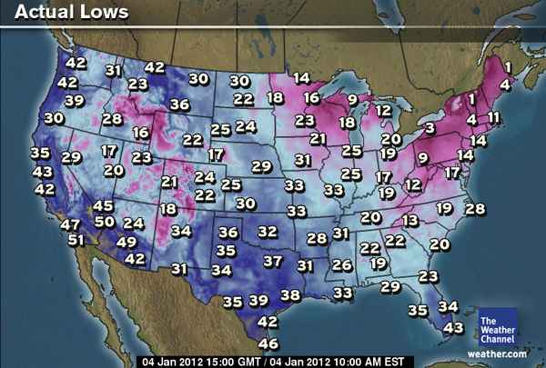
Wednesday morning was the coldest morning since last winter for the East.
The low of 17 degrees in Washington, D.C., Wednesday morning ties the coldest temperature recorded last winter.
Philadelphia, New York City and Boston all recorded the coldest temperatures since Jan. 24, 2011, with Wednesday morning lows of 14, 13 and 11, respectively.
In Buffalo, N.Y., the low dropped into the single digits, reaching 3 degrees, or the coldest since Jan. 24, 2011.
The morning low in Raleigh, N.C., bottomed out at 20 degrees, the coldest temperature recorded since Jan. 23, 2011.
Atlanta was frigid with a morning low of 23 degrees. That is the coldest temperature since Jan 14, 2011.
The temperature in Miami plummeted to 43 degrees, the coldest temperature recorded their since Dec. 28, 2010.
Records lows set or tied Wednesday morning:
-Naples, Fla.: 36 degrees (old record 39/2002)
-Gainesville, Fla.: 20 degrees (old record 22/1900)
-Alma, Fla.: 19 degrees (old record 21/2001)
-Tallahassee, Fla.: 18 degrees (tied record 18/1928)
-Jacksonville, Fla.: 22 degrees (tied record 22/1887)
-Apalachicola, Fla.: 26 degrees (tied record 26/2010)
The record cold temperatures in Florida made some thin-blooded Floridians uncomfortable.
Abstract from AccuWeather article
Harshest Cold of the Season So Far in the East
ACCUWEATHER.COM
Bitter Cold Gripping the East Soon to Depart
ACCUWEATHER.COM

Canada Latest
Canada Divided between spring in west while winter shivers east
Record warmth settles into the Prairies
THE WEATHER NETWORK

Australia Latest
Near-Record Australia Rainfall in 2011
ACCUWEATHER.COM
THE EXTREMES OF THE DAY
TODAY’S US EXTREMES
COURTESY OF ACCUWEATHER
HIGH: 91° at San Gabriel, CA
LOW: -17° at Saranac Lake, NY
TODAY’S UK EXTREMES
COURTESY OF THE MET OFFICE
HIGH: 51° (10.7°C) at Portglenone (Co Antrim)
LOW: 32° (-0.2°C) at Leuchers (Fife)
TODAY’S EXTREMES HERE AT MY HOUSE
HIGH: 47°
LOW: 34°
Thanks for reading.
-Mark


Recent Comments