>
Join The Conversation!
Today’s Weather Headlines
Europe Latest
Restbite comes to Britain this afternoon as high pressure moves in following another wild night
Winds were clocked at 93 mph in hills around Sheffield last night
Meant to say 2012 in title of course!
Strong winds cause disruption around UK
BBC

Storm to hit southeastern Europe
BBC
Signs of an Arctic visit for Europe down the road?

When the stratosphere warms over the polar region of the hemisphere, this tends to draw the coldest air both from the high atmosphere down to the surface as well as drawn southwards into the mid-latitudes.
This is occuring and Asia will feel the full effects of this by weeks end and into early next week, as will North America, especially from mid to late next week. It appears a warming of the 10mb level or stratosphere from Siberia around the pole and over northern North America is drawing the most frigid pools of Arctic air into these very regions of the hemisphere, my point here is that if you take a look at this chart below which shows temperature at the stratospheric level of the atmosphere (10mb), well it appears to show warming over much of Europe, particularly from Ireland northeastwards into Scandinavia with warmth maxing out over Sweden and Finland. So, would this suggest much colder, Arctic air heading our way sometime after January 15? It’s possible, certainly the signs are there but we need to see that blocking high build northwards from the N. Atlantic up over Greenland in order to then draw in that Arctic air south and underneath the warm blocks. This warming at 10mb may be the trigger to the crucial NEGATIVE NAO (North Atlantic Oscillation) Britain, Ireland and western Europe need for brutal and persistent Arctic air to set up shop.
Time will tell but I urge you, NOT TO DISMISS WINTER. It’s been one of the most amazing December and early January periods i’ve ever witnessed in terms of the shear power of atmosphere and what it’s capable of. Just think, we’re probably within one of the storminest regions of the planet right now or was when it comes to oceanic storms which have came in one after the other and in some cases mere 24 hours apart, bringing hurricane-force winds, damage and flooding rains.
US Latest
Potentially all-time record January highs today across Northern Plains
According to The Weather Channel, it’s currently 72 degrees at Rapid City, SD!
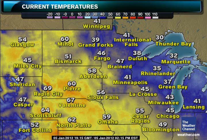
Dozens of Record Highs in Jeopardy Today
ACCUWEATHER.COM
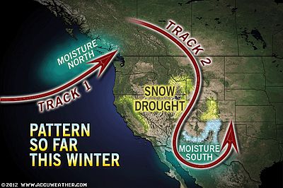
Huge flip back to reality next week?

Storm Next Week May Set Up New Weather Pattern
ACCUWEATHER.COM
Serious Implications from US Snow Drought?
ACCUWEATHER.COM
Canada Latest
Record breaking warmth covers western Canada but is there severe cold looming next week?
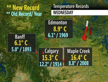
Record warmth settles into the Prairies
THE WEATHER NETWORK
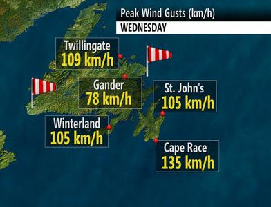
Damaging winds pound Newfoundland
THE WEATHER NETWORK
Asia Latest
Heavy snows impacts Beijing and northern China, drought worsens in other places
Bus Slides Off Snow-Covered Bridge in China, 16 Dead
FOX NEWS
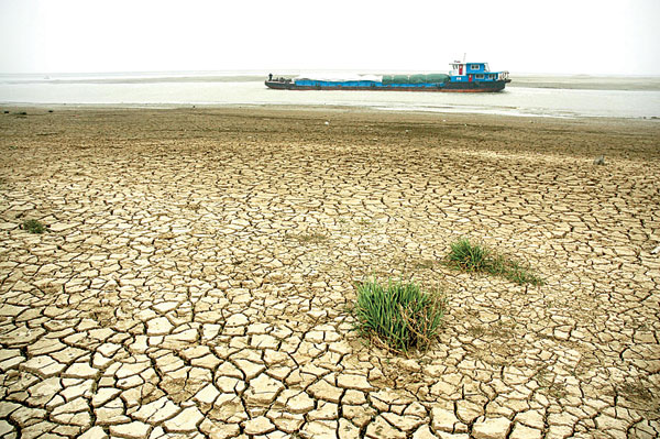
Drought drying out Poyang Lake
CHINA DAILY
South America Latest
Major Flooding Impacts Brazil
Floods hit southeastern Brazil
BBC
Australia Latest
THE EXTREMES OF THE DAY
TODAY’S US EXTREMES
COURTESY OF ACCUWEATHER
HIGH: 88° at Lake Forest, CA
LOW: -4° at Moose, WY
TODAY’S UK EXTREMES
COURTESY OF THE MET OFFICE
HIGH: 54° (12.3°C) at Swanage (Dorset)
LOW: 33° (0.6°C) at Dalwhinnie (Highland)
TODAY’S EXTREMES HERE AT MY HOUSE
HIGH: 47°
LOW: 35°
Thanks for reading.
-Mark


Recent Comments