>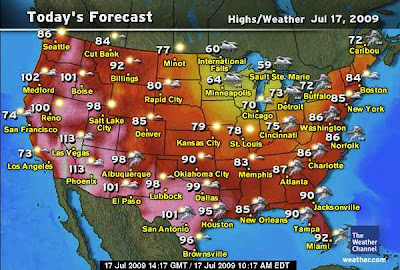

A very interesting weather map is shaping up as we see heat surge north from the cauldron of hell centered over the Desert Southwest. As this high expands and bulges over the Arizona Desert where high’s are likely to soar towards 120 degrees in areas not far from Phoenix we are seeing the spread of heat northbound towards Western Canada. Death Valley yesterday was 125 degrees for it’s warmest so far. When you support a 100 degree air mass all the way to the interior Northwest and 90s into the heart of western Canada, you put pressure on the entire atmosphere across North America, the flexing this brutal blowtorch is causing the atmosphere to essentially swell into the upper reaches of the atmosphere and wrickles are created outward, similar to throwing a stone into water, causing changes upstream. Problem is, the same blob of cold over eastern Canada that has been refridgerating the Northeast and Lakes all summer needs to now get shunted somewhere and the atmosphere’s path of least resistence is south into the heart of the eastern US. Amazingly all the way down into the Gulf of Mexico.
The next few days will illustrate just how hot things can get in the Southwest deserts and at the same time we will also see how chilly the air is north of the border as we will likely see record cool highs and deffinately record lows. The vast meridional or highly amplified upper air flow is created because of the building heat over the Deserts, but the power of the trough is a side-effect of the actual high that’s working against it. But a key element is just how cold the air is over eastern Canada see highs only in the 60s in Minnespolis to Chicago in Mid-July is remarkable to achieve, it’s hard to see cool when the atmosphere is molded into a summer-time regime which makes it so much easier to get 85-90 than to acheive 65. There’s simply too much hot air around this time of year to push out tropical, deep layered that wants to get as far north as possible. The cooler air is harder to come across and usually the really chilly stuck is that far north, it’s often near impossible to pull 50-60 degree air perhaps 3,000 miles without warming it. So to achieve 60s in the Midwest and 100s across a large area of the West is quite amazing.
Another key thought is that when highs only top the mid to upper 60s across a large area from Minneapolis to Pittsburgh and only 70s deep into the Tennessee-Mississippi valleys will be the dry air will be easier to cool sufficiantly that we will likely see areas down into the 30s in the cold hallows and frost formation is a good possibilty afterall it was just on Tuesday when we saw low 40s in central Pennsylvania where Jesse Ferrell of AccuWeather recorded a chilly 43 degrees at his house. Pittsburgh broek a 113-year record with a low of 51 degrees. A remarkable 27 degree low was recorded by a co-op site at Atlanta, Michigan…
I fully expect a stunning display of cold at the same time we see records fall across the West was the blow torch rages on full. I am calling for at least 115 at Phoenix, 114 at Las Vegas and 128 at Death Valley over the next few days as pressures strive to hit 600dm which is about as high as pressures go…. Could we even see a shock 130 at Death Valley? I have seen 128 and 129 but not 130!!! Come on… just this once??
More coming up later today.
Thanks for reading
-Mark


Recent Comments