ARTICLE FROM WEATHER.COM
Story Highlights
In the second week of November, snow cover across the U.S. is hard to find.
It’s the least areal coverage of snow in the U.S. for any Nov. 8 in the last 13 years.
Widespread record warmth and a diverted jet stream are to blame.
Overall, this doesn’t necessarily portend a mild winter.
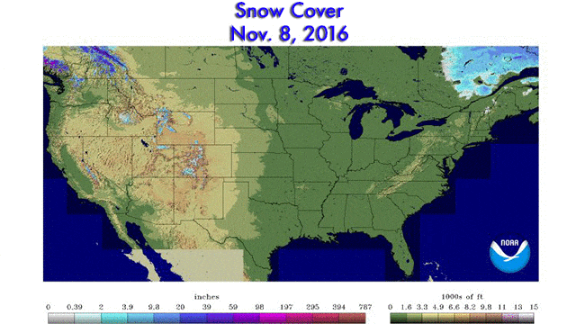
The areal extent of snow cover in the Lower 48 of the United States on Nov. 8 reached lows not seen on that date in over a decade, according to a government analysis.
Only 1 percent of the land area of the contiguous U.S. had snow on the ground on the morning of Election Day 2016, according to NOAA’s National Operational Hydrologic Remote Sensing Center’s National Snow Analysis.
(MORE: The Coldest Temperatures Ever Recorded in All 50 States)

Snow cover analysis on November 8, 2016, over the Lower 48 states.
You have to squint at the map to find any snow on the ground east of the Rockies; only a few locations in far northern New Hampshire and northwest Maine appeared to have any snow.
Outside of ski resorts making their own snow, it’s not exactly plentiful in the West, either. The NOAA/NOHRSC analysis suggested only some peaks of the northern and central Rockies, Sierra and Cascades have any snow at all on the ground.
This dearth of early-season snow can be attributed to record recent warmth, a storm track recently diverted into Canada and, when wet Pacific storms do arrive, the dominance of warm air raising snow levels.
How Unusual Is This?
We’ve just passed the halfway point of fall. A sizable swath of the nation still has yet to see its first flakes of snow this season, but that is typical.
(MORE: When the First Snow of the Season Typically Falls)

Month of the average first accumulating (0.1 inch or greater) snowfall of the season, according to 30-year average statistics. (NOAA/NWS/NCEI)
On average, only about 7.6 percent of the area of the Lower 48 states have snow on the ground on Nov. 8.
However, this is the least widespread U.S. snow cover on Nov. 8 in records dating to 2003, according to NOAA/NOHRSC.
But it’s the relative lack of snow on the ground in the mountain West that is most anomalous. For instance, on Nov. 8, 2015, Mount Rainier’s Paradise Ranger Station reported 13 inches of snow on the ground.
One year later, not so much. Only a few, crusty old piles of snow in spots remained for park visitors to behold.

Web cam still of the Jackson Visitor Center at Mt. Rainier National Park in southwest Washington state on the morning of November 8, 2016. (National Park Service)
Several recent Eighths of November have also featured rather pathetic snow cover at this time of year, including 2014 (3.9 percent), 2010 (2.1 percent), 2009 (3.1 percent), 2006 (1.6 percent) and 2004 (3.9 percent).
November 8 snow cover in the contiguous U.S. from 2003-2016, ranging from 21.2 percent areal coverage in 2011 to 1 percent in 2016. (NOAA/NOHRSC)
Any Indicator on the Rest of Winter?
Admittedly, we’re just looking at one calendar day in the past, rather than a composite of an early to mid-fall period. But there is no correlation in recent years between early November U.S. snow cover, or lack thereof, and the severity of the following winter.
(MORE: Winter 2016-2017 Outlook)

Cars remain buried on East 4th St. on February 10, 2015 in Boston, Massachusetts. (Photo by Scott Eisen/Getty Images)
The sports analogy to this is fretting over your favorite NFL team’s Week 1 performance or the first two series of the Major League Baseball season. It’s just too soon to tell, regardless of the early results.
Snow cover extent was also rather paltry on Nov. 8, 2009 (3.1 percent of the Lower 48 states) and 2014 (3.9 percent), yet the winters that followed saw record snow in Washington D.C. and Philadelphia in 2009-10 and in Boston in 2014-15.
There are numerous drivers of the atmospheric circulation over a winter period in the U.S., including:
1. How often and exactly where blocking high-pressure ridges form in the northern Atlantic Ocean, forcing cold air south into the eastern two-thirds of the U.S.
2. The presence or absence of El Niño or La Niña.
3. Whether and how often splits of the stratospheric polar vortex occur.
Factors 1 and 3 above can change relatively quickly – on the order of a few weeks – in the season, changing the weather pattern in some areas from warm and snowless to cold and snowy.
We should mention that there is recent research suggesting that the extent of snow cover in Siberia in early fall may play a role in the following winter in the U.S. So far this fall, snow cover has been more extensive than normal, according to Rutgers University’s Global Snow Lab.
(MORE: Siberia Snow Blitz -> Harsh Winter Ahead?)
If you can’t wait for snow, remember all these recent nice days in the 60s and 70s when you’re clearing your driveway of a foot of snow in January.


Recent Comments