>
Join The Conversation!
NEW WEBSITE COMING SOON!
US LATEST
Plains/Ohio Valley Blowtorch Slides East, So Does Severe Threat
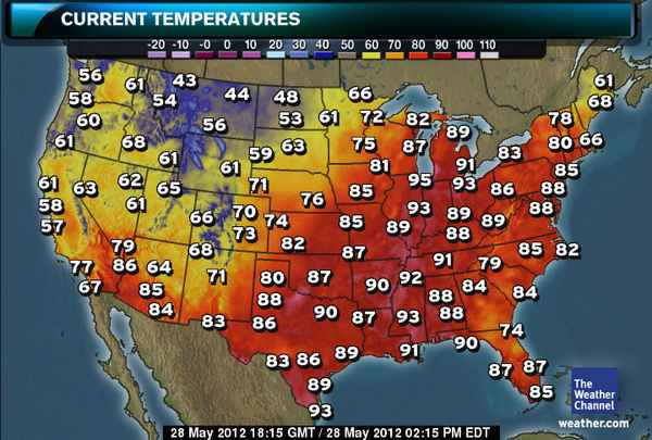
Temps as of 2pm CDT hit 95 degrees at Chicago O’Hare Airport which not only breaks a daily record but makes this the hottest Memorial Day on record. Powerful storms will likely push through the area late afternoon and or evening.
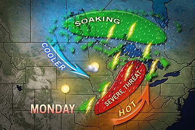
Severe Storms to Slam Chicago, St. Louis, Springfield
ACCUWEATHER
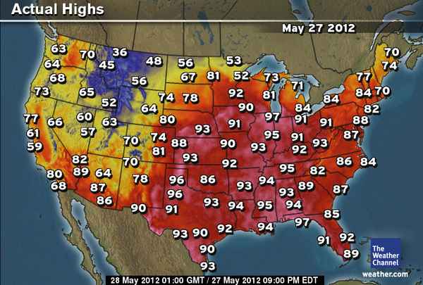
Weather records continue to fall; will today be any different?
CHICAGO TRIBUNE
Beryl Makes Landfall As 70 mph Tropical Storm Near Jacksonville Beach, FL At 12.10am This Morning
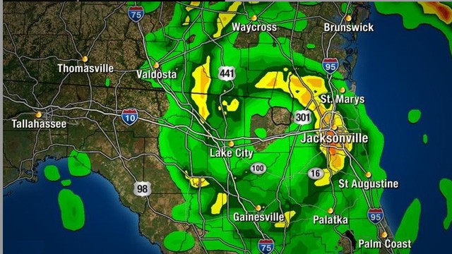
Beryl downgraded to depression; rains continue
NEWS4JAX.COM
What’s Next for Beryl?
ACCUWEATHER
Tropical Storm Beryl makes landfall on Florida coast
FOX NEWS

Video Of Tropical Storm Beryl
All videos from YouTube
EUROPE LATEST
UK Returns To Normality Tuesday As Cold Front Brings Return Of Cool Weather From Scandinavia
Well I noticed a sharp temperature decline this evening with my current outside temp now pushing 10C (50F), feeling cooler in the wind and likely heading for 5 or 6C (low 40s) tonight. In fact following rapid warming through this morning and early afternoon with not a breathe of wind, all of a sudden, while skies remained clear with blazing sunshine, winds picked up and became strong through the afternoon and this was the game changer with a gradual temp decline following an early peak at 77F. As of 10pm this evening, we’re already in another air mass, one originating from the north. Highs won’t reach 60 on Tuesday, a very big drop from today’s high and yesterday’s 79F high this afternoon which made for the 5th 70+F day here with one day reaching 81F.
While the low to mid-20sC (mid to upper 70s F) dominated the Highlands, south of Inverness today, to the north it was only around 14C (57F) thanks to the passing of a cold front. That cold front will push south tonight and by tomorrow, Scotland will be mostly cloudy and struggling to hit 15C. That’s a big difference and will feel quite chilly as our bodies will have ajusted to the warmer weather.
Southern England will still warm into the low 20s C but their days in the warmth are also numbered thanks to a trough dropping out of Scandinavia.
By the time we reach Wednesday highs for many in Scotland will have a tough time reaching 14C, while southern areas perhaps 18 or 19C.
A cool northerly air flow will keep us nearer normal but thankfully high pressure returns following a dull Tuesday and Wednesday.
For parts of England, watch for more thunderstorms developing during the late morning and afternoon as the surface warms.

ASIA LATEST
Severe Weather Impacts Japan
Deadly Storms in Japan & Tropical Update 28-29 May, 2012
WESTERNPACIFICWEATHER
AUSTRALIA LATEST
Boome, Western Australia Experiences Their Coldest May Night On Record
THE EXTREMES OF THE DAY
TODAY’S US EXTREMES
COURTESY OF ACCUWEATHER
HIGH: 102° at Death Valley, CA
LOW: 16° at Angel Fire, NM
TODAY’S UK EXTREMES
COURTESY OF THE MET OFFICE
HIGH: 82° (27.7°C) at Santon Downham (Suffolk)
LOW: 38° (3.4°C) at Ravensworth (N Yorkshire)
TODAY’S EXTREMES HERE AT MY HOUSE
HIGH: 77°
LOW: 55°
Thanks for reading.
-Mark


Recent Comments